List of earthquakes in the Philippines
The Philippines lies along the Pacific Ring of Fire, which causes the country to have frequent seismic and volcanic activity. Many earthquakes of smaller magnitude occur very regularly due to the meeting of major tectonic plates in the region. The largest was the 1918 Celebes Sea earthquake with Mw8.3.
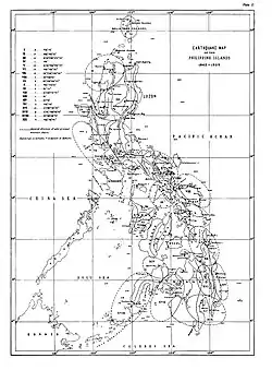 A 1910 earthquake map of the Philippines | |
| Largest | Mw8.3 1918 Celebes Sea earthquake |
|---|---|
| Deadliest | Mw 8.0 1976 Moro Gulf earthquake 5,000–8,000 killed |
Spanish period
Earthquakes recorded from the 17th to 19th century:[1]
17th century

| Date | Epicenter and Effects | |
|---|---|---|
| Year | Month | |
| 1601 | January | Manila and adjacent provinces. Considerable damage to some churches and many private houses in Manila. Its duration was unusually great, it being said that during 7 minutes the shocks were almost continuous. There were several dead and a great number of injured. The aftershocks were frequent throughout the year. |
| 1628 | — | Camarines and Albay. A destructive earthquake in which, it is said, a mountain burst and emitted a river of water and mud which swept away the town of Camarines and others. The name of Camarines was at the time used to designate the present town of Camalig, Albay and the district near the southern slopes of Mayon Volcano. The flood mentioned was probably an avalanche of water, sand, volcanic ashes, and lapilli, such as also on other occasions have occurred on the slopes of the same volcano during periods of torrential rains. |
| 1645 | November |
The most terrible earthquake recorded in the colonial history of the Archipelago. It was said that from Manila to Cagayan and Ilocos Norte it left no stone unturned. In the capital, where during the preceding fifty years a great number of stone buildings had been erected, churches, palaces, and public buildings, as well as private residences and villas, the destruction was frightful. Ten churches were wrecked entirely: the Royal Chapel, Cathedral, Santo Domingo, those of the Recollects and Franciscans, Santiago, San Antonio, Nuestra Señora de Guia, and the parish churches of Binondo and San Miguel; only San Agustin and the Jesuit Church remained standing. Twelve monasteries, colleges, and hospitals were likewise destroyed, as were the palace of the Governor-General, the Real Audiencia and up to 150 of the finest residences which, as one author puts it, "in other cities would have been considerable palaces." The rest of the private houses were severely damaged that the majority had to be demolished. The number of persons killed exceeded 600 and the total of killed and injured was stated to have been 3,000. Outside Manila there was a general destruction of villas and other buildings which had been erected on both banks of the Pasig River. Throughout the neighboring provinces the masonry structures built by the missionaries were also destroyed. From the farthest provinces in the north were reported great alterations of the surface with almost complete disappearance of some native villages, changes in the courses of rivers, subsidences of plains, eruptions of sand, etc. All the writers of the time qualify this disturbance as the most disastrous earthquake not only in Luzon, but likewise in Mindoro, Marinduque, and the other islands south of Luzon. On the other hand, the provinces of Camarines and Albay appear to have suffered little. |
| 1665 | June | Destructive in Manila and adjacent provinces. In the ruins of numerous houses 19 persons died and many more were injured. Of public buildings only the Jesuit Church was mentioned as having suffered to some extent. |
| The inclusion criteria for adding events are based on WikiProject Earthquakes' notability guideline that was developed for stand alone articles. The principles described are also applicable to lists. In summary, only damaging, injurious, or deadly events should be recorded. | ||
18th century
.jpg.webp)
| Date | Epicenter and Effects | |
|---|---|---|
| Year | Month | |
| 1787 | July | Panay Island. A strong earthquake which devastated the island. Of 15 to 20 churches and conventos in Iloilo only two or three remained standing; in Capiz and Antique, the destruction was less extensive. Even the thick walls of the fort at Iloilo were breached in many places. There were subsidences in the plains and landslides in the mountains and mighty fissures opened. It is stated that the victims were numerous: in one building 15 persons died. |
| The inclusion criteria for adding events are based on WikiProject Earthquakes' notability guideline that was developed for stand alone articles. The principles described are also applicable to lists. In summary, only damaging, injurious, or deadly events should be recorded. | ||
19th century


.jpg.webp)

| Date | Epicenter and effects | |
|---|---|---|
| Year | Month | |
| 1840 | — | Destructive earthquake in Sorsogon and Masbate. Ruined masonry buildings. In Sorsogon Bay extensive subsidences occurred; the sea invaded the town, causing great destruction and claiming many victims. |
| 1852 | September | Central Luzon. Destructive earthquake strongly felt in present-day Rizal, Laguna, Cavite, Batangas, Tayabas, Bataan, Zambales, Pampanga, Bulacan, and Nueva Ecija. In Manila it severely damaged many buildings, among them the cathedral and the churches of the Jesuits, San Miguel, and Paco, the church and convento at Pandacan (near Manila), and houses. It is stated that the damage was relatively greater in Bataan, Cavite, and Batangas, where many fissures opened and subsidences and landslides occurred. The zone most affected seems to have stretched from the Zambales Mountain Range as far as the coasts of Batangas and Northern Mindoro. Aftershocks were frequent until the middle of October. |
| 1863 | June |
Manila and adjacent provinces. A disastrous earthquake, comparable with that of 1645. Destroyed the cathedral and nearly all the other churches, except San Agustin, the palace of the Governor-General, the Audiencia, the barracks, warehouses, etc.; all in all, 46 public buildings in ruins and 25 others badly damaged. Of private houses 570 were destroyed, 531 left tottering. A total of 1,172 buildings destroyed or badly damaged. It is estimated that in Manila and the surrounding towns alone the number of dead reached 400, that of the injured 2,000. |
| 1869 | August | Masbate Island. Destroyed the few masonry buildings extant on the island and ruined or inclined hundreds of houses of wood or light materials; large trees fell, fissures opened, and vast landslides occurred in the mountains and along the coasts, especially in the south of the island. Countless repetitions followed, over 100 of the more severe ones having been counted during the first fortnight after the earthquake. |
| 1869 | October | Neighboring provinces east and south of Manila, and northern Mindoro. On Luzon the provinces chiefly affected were present-day Rizal, Laguna, Cavite, and Batangas. In Manila this earthquake did considerable damage to quite a number of buildings. In Cavite and Batangas a few churches and conventos were destroyed. There was no loss of life. Aftershocks were frequent during the next five days. |
| 1879 | June |
Surigao Peninsula. Caused extensive damage to buildings and the topography of the region. Not a single stone building remained inhabitable, although some of them, like the church, government house, and prison at Surigao, were of mostly solid construction. Besides the opening of innumerable fissures and vast landslides on the coasts and in the mountains, extensive subsidences occurred : several accurate observations seem to prove that a great part of the peninsula was depressed by about 2 feet. In short, this earthquake was one of those which produced the greatest changes of topography experienced in the Philippines. There followed other very strong quakes on July 5, 24, and 28, and August 8, with countless repetitions of less importance during several months. From July 1 to 15 occurred on the average 5 perceptible shocks per day. |
| 1880 | July |
Earthquake of destructive violence in the towns surrounding Lake Bay, especially in those south and west of the lake. Within the epicentral region of the three preceding earthquakes, which measures about 300 kilometers from north to south and 200 kilometers from east to west, severe damage was done to the principal stone buildings, such as churches, conventos, court-houses, schools, and a few private houses, of 112 of the city principal towns. In Manila some 30 public buildings (administration buildings, barracks, churches, monasteries, and colleges) and about 200 private houses of strong materials were either wrecked or badly damaged. The number of victims was not in proportion to the magnitude of the disaster. From the various reports published at the time it is estimated that the number of deaths did not exceed 20, nor that of the injured exceed 50. |
| 1892 | March |
Disastrous earthquake in Pangasinan, La Union, and Benguet. It severely damaged masonry buildings, such as churches, conventos, court-houses, and schools, besides a few private houses, of 30 of the principal towns within the meizoseismic area, produced great fissures and extensive subsidences in the alluvial plains, and many landslides in the steep mountains of northern Pangasinan. Falling buildings killed only one or two persons. Aftershocks were frequent up to the end of the month; of these three occurring on 17 March and one each on the 26 and 28 March were of exceptional intensity. |
| 1897 | September |
Disastrous earthquake in Zamboanga, Basilan, and Jolo. It destroyed buildings and produced fissures, landslides, and similar effects. A formidable "tsunami" (tidal wave) claimed hundreds of victims on the western shores of Basilan. This "tsunami" was the most imposing recorded in the seismological history of the Archipelago. There followed innumerable aftershocks during 18 months, 200 having been counted before the middle of October, of which those on September 22, 23, 24, 26, and 29, and October 12 and 15 deserve special mention on account of their great intensity. |
| The inclusion criteria for adding events are based on WikiProject Earthquakes' notability guideline that was developed for stand alone articles. The principles described are also applicable to lists. In summary, only damaging, injurious, or deadly events should be recorded. | ||
American period and post–World War II (1900–1999)
.svg.png.webp)
20th century
| Year | Description and effects |
|---|---|
| 1912 | A magnitude 7.5 quake struck Northeastern Mindanao on July 11. Damage and high intensity shaking were experienced in the towns of La Paz, Bunawan, Veruela and Talacogon in the Agusan Valley where intense ground shaking, liquefaction, widespread landslides and river/lake seiches occurred.[9] |
| 1918 | The Mw 8.3 Celebes Sea earthquake occurred on August 15, with a maximum Mercalli intensity of X (Extreme). The offshore shock affected the southern Philippines with high intensity shaking and a destructive tsunami that left 52 people dead. |
| 1924 | A strong magnitude 8.0 earthquake struck Southern Mindanao on April 14.[10] At least 500 people were killed and many houses were destroyed. A destructive tsunami was also generated, which was observed as far away as Balut Island, Sarangani Bay.[11][12][13] |
| 1948 | A magnitude 7.8 Mw earthquake struck Panay Island on January 25, at 1:46 am. The epicenter was between the municipalities of Anini-y and Dao (now Tobias Fornier) in Antique province. |
| 1949 | An intensity VII earthquake struck Luzon, mainly Isabela on December 29. Starting at 11:05 am, it lasted for two-and-a-half minutes. The damage was moderately destructive, causing landslides and rough waves capsizing boats, as well as fissures that spat out black water.[14] |
| 1955 | A magnitude 7.4 Mw earthquake struck Mindanao on April 1, at 2:14 am. The quake killed between 225–465 people and injured 868–898 others. |
.svg.png.webp)
Mid to Late 20th century
| Year | Description and Effects |
|---|---|
| 1968 | A magnitude 7.6 earthquake struck Casiguran, Aurora, on August 2, at the depth of approximately 31 km (19 mi). It was considered the most severe and destructive earthquake experienced in the Philippines during the last 20 years. 270 people were reported dead and 261 were injured. |
| 1970 | A magnitude 7.4 earthquake struck Baler, Aurora, on April 7, at 1:34 pm. PST at the depth of approximately 25 km (16 mi). 15 people died and around 200 others were injured. The earthquake damaged or destroyed buildings especially in Manila, where a school collapsed.[21][22][23] |
| 1973 | A magnitude 7.0 quake struck Ragay Gulf on March 17. Calauag, Quezon was the worst hit, as the quake caused 98 houses totally destroyed, and 270 more were partially damaged.[24] |
| 1976 | A magnitude 8.0 earthquake struck Mindanao on August 16. The quake caused a devastating tsunami that had hit the 700 km coastline of the island of Mindanao bordering Moro Gulf in the North Celebes Sea. An estimated 5,000 – 8,000 people died. The major cause of the great number of casualties during the event could be attributed to the fact that the quake happened just after midnight when most people were sleeping; and a great tsunami was spawned, struck the coasts from different directions and caught the people unaware.[25] |
| 1983 | A magnitude 6.5 earthquake struck Laoag on August 17, at a depth of 42 km (26 mi). The quake has caused the deaths of 16 and injured 47 people.[26] |
| 1988 | A magnitude 6.2 earthquake struck Mindoro on June 20, at a depth of 16.7 km (10.4 mi). The quake has caused the deaths of 2 and injured 4 people.[27] |
| 1990 | A magnitude 6.8 earthquake struck Bohol on February 8. Six fatalities were reported and more than 200 were injured in the event. About 46,000 people were displaced by the event and at least 7,000 among them were rendered homeless. Estimated damage to properties is amounting to ₱154-million.[28] |
| 1990 | A magnitude 7.1 earthquake struck Panay Island on June 14 at a depth of 15 km (9.3 mi). Eight people died and 41 others were injured.[29] |
| 1990 | A magnitude 7.8 earthquake struck Luzon on July 16. It caused severe damage to major cities in Luzon: Dagupan (soil liquefaction), Baguio, and Cabanatuan; Hyatt Terraces Baguio collapsed. 1,621 were reported dead. Damage to buildings, infrastructures, and properties amounted to at least ₱10-billion, a part of which was caused by ground rupturing. However, some houses within 1–2 m on either side of the ground rupture survived owing to their light-weight construction while those built of reinforced concrete within this zone suffered partial damage. Damage beyond 2m depended mainly on the structural integrity of the building and effects of local topography and ground conditions.[25][30] |
| 1994 | A magnitude 7.1 earthquake struck Mindoro on November 15 at depth of 15 km (9.3 mi). The quake caused a tsunami killed 41 people, injured 250, and destroyed 1530 houses.[31][32] |
| 1995 | A series of large earthquakes struck Samar on April 21, with four of the largest earthquakes being near magnitude 7 and the largest one registering at magnitude 7.3. The earthquakes also resulted in a small tsunami that was recorded in Legazpi, Albay. The area was hit by another earthquake of magnitude 7.0 on May 5 of the same year.[33] |
| 1996 | A magnitude 5.6 earthquake struck Bohol on May 27, at a depth of 4 km (2.5 mi). The earthquake did not cause major damage to properties. Damage was confined to poorly built structures and/or old wooden, masonry, limestone walls of houses and buildings, generally due to ground shaking.[34] |
| 1999 | A magnitude 5.1 earthquake struck Bayugan, Agusan del Sur on June 7 and 9. The towns of Bayugan and Talacogon were the most devastated.[9] |
| 1999 | A magnitude 6.8 earthquake struck northwest of the coast of Zambales on December 12. The earthquake killed six people and injured 40 in Zambales, Pangasinan, and Metro Manila. The quake also caused power outages throughout Manila.[35] |
21st century
Largest earthquakes by year

The largest or most notable Philippine earthquakes per year since 2001. As for the repeated entries, Moro Gulf near the Cotabato Trench is a seismically active area (the location of the devastating 1918 Celebes Sea earthquake and 1976 Moro Gulf earthquake). Meanwhile, Samar and Davao Region are near the northern and southern portions of the Philippine Trench, respectively.
| Year | Magnitude | Location | Date | |
|---|---|---|---|---|
| 2001 | 7.5 | Philippine Sea near Tarragona, Davao Oriental[36] | January 1 | |
| 2002 | 7.5 | Moro Gulf | March 5 | |
| 2003 | 6.5 | Philippine Sea near Borongan, Eastern Samar | November 18 | |
| 2004 | 6.5 | Batangas Bay near Mabini, Batangas | October 8 | |
| 2005 | 6.4 | Moro Gulf, Mindanao[37] | November 30 | |
| 2006 | 6.3 | Luzon Strait near Babuyan Island | October 9 | |
| 2007 | 6.4 | Davao Gulf near Governor Generoso, Davao Oriental[38] | August 20 | |
| 2008 | 6.9 | Philippine Sea near Cabodiongan, Eastern Samar | March 3 | |
| 2009 | 6.6 | Moro Gulf, Mindanao | October 4 | |
| 2010 | 7.6 | Moro Gulf, Mindanao | July 23 | |
| 2011 | 6.4 | Luzon Strait near Fuga Island, Cagayan | March 20 | |
| 2012 | 7.6 | Philippine Sea near Guiuan, Eastern Samar | August 31 | |
| 2013 | 7.2 | Sagbayan, Bohol | October 15 | |
| 2014 | 6.6 | Moro Gulf, Mindanao[39] | December 2 | |
| 2015 | 6.1 | Philippine Sea near Burgos, Surigao del Norte[40] | July 3 | |
| 2016 | 6.3 | Philippine Sea near Mati City, Davao Oriental[41] | September 24 | |
| 2017 | 7.2 | Sarangani Bay near Sarangani, Davao Oriental[42] | April 29 | |
| 2018 | 7.2 | Davao Gulf near Governor Generoso, Davao Oriental | December 29 | |
| 2019 | 6.9 | Matanao, Davao del Sur | December 15 | |
| 2020 | 6.6 | Masbate Pass near Cataingan, Masbate | August 18 | |
| 2021 | 7.1 | Governor Generoso, Davao Oriental | August 11 | |
| 2022 | 7.0 | near Tayum, Abra | July 27 | |
| 2023 | 6.0 | near Montevista, Davao de Oro[43] | February 1 | |
| The inclusion criteria for adding events are based on WikiProject Earthquakes' notability guideline that was developed for stand alone articles. The principles described are also applicable to lists. In summary, only damaging, injurious, or deadly events should be recorded. | ||||
2001–present
Only earthquakes of magnitude 7.0+ are included, unless the event is notable such as causing casualties, or significant damage.
- A magnitude 7.5 quake struck Mindanao on January 1, 2001, at a depth of 33 km.[44]
- A magnitude 7.5 quake struck Southern and Central Mindanao on March 5, 2002 at a depth of 31 km.[45] At least 15 people were killed, 100 injured and 800 buildings were damaged or destroyed.[46]
- A magnitude 6.1 quake struck Sultan Kudarat on March 6, 2002. Office of Civil Defense (OCD) records show that 8 people had died and 41 were injured due to the earthquake. It affected 7,684 families in the provinces of Sultan Kudarat, Sarangani, North Cotabato and South Cotabato including four cities and 17 municipalities.[47]
- A magnitude 6.2 quake struck Masbate on February 15, 2003, at a depth of 22 km. The quake damaged major infrastructures in Masbate.[48]
- A magnitude 6.5 quake struck Can-avid, Eastern Samar on November 18, 2003. A five-year old child died, crushed by a falling wall, while 21 others, including his mother, suffered injuries. Many structures were damaged or destroyed in various parts of the province, including a school. A landslide occurred in the town of Taft. Power outages occurred throughout Eastern Samar.[49][50][51]
- A magnitude 5.7 earthquake hit Sultan Kudarat on September 18, 2009. At least 91 people were injured and 76 houses, 2 commercial buildings, and a fence of a high school were damaged in the province as well in neighboring South Cotabato. In the town of Norala, two houses were totally destroyed.[52][53]
- A series of quakes with the main quake's magnitude 7.3 struck Moro Gulf on July 23–24, 2010.
- A magnitude 5.2 quake struck Valencia City, Bukidnon on November 8, 2011, at a depth of 1 km.[54] 39 people were injured, and several establishments were damaged.[55]
- A magnitude 6.9 quake struck Negros, the rest of Central Visayas, and some parts of Mindanao on February 6, 2012, at a depth of 20 km. The quake killed people, caused major damage on infrastructures, and buildings. A tsunami alert level 2 was raised due to the quake. The quake also caused a landslide, burying a barangay. More than a thousand of aftershocks were recorded by PHIVOLCS within 2 days since the quake occurred.[56][57][58] According to National Disaster Risk Reduction and Management Council, as of February 18, 2012, the death toll have risen to 51 with 62 people still missing, and injuring 112 people. Most deaths came from the city of Guihulngan and La Libertad where landslides occurred. 63, 697 from provinces in Region VII were affected by the quake. 15, 483 houses were partially or totally damaged, and a total of ₱383-million worth of damage to buildings, roads and bridges, and other infrastructures were recorded.
- A magnitude 5.9 quake struck Surigao City on March 16, 2012. Many were injured in the city for that certain day was the grand opening of Gaisano Capital Surigao. An estimated 6,000 people were in Gaisano when the earthquake happened. The earthquake caused a stampede which injured people.[59][60][61]
- A magnitude of 7.6 quake struck 106 km near Guiuan, Eastern Samar on August 31, 2012. It was also felt in certain areas of Visayas and Mindanao. One person died, and another one was injured in Cagayan de Oro after being trapped in a collapsed house due to a landslide.[62] Minutes after the quake, power interruptions occurred in the affected areas. The National Disaster Risk Reduction and Management Council reported that a house in Agusan del Sur province caught fire sparked by a gas lamp that was toppled during the earthquake. It also reported that two bridges in Eastern Samar, particularly the Buyayawan Bridge in Mercedes town and the Barangay Casuroy Bridge in San Julian town, were partially damaged. The Abreeza Mall in Bajada, Davao City suffered minor cracks on the floor due to the earthquake.[63] In General MacArthur, Eastern Samar, 77 homes were damaged. There were also 6 houses damaged in Barangay Casoroy, San Julian.[64] In Balangiga, Eastern Samar, a hospital sustained serious damage.[65] A wall from an old building collapsed in Butuan.[66] The NDRRMC reported on Saturday noon there were cracks on some roads and bridges and other establishments in areas where the quake was felt.[67] Most of the homes destroyed were those made of light materials, while overall damage to infrastructure remained minimal.[68] A tsunami warning of Level 3 was raised by the Philippine Institute of Volcanology and Seismology, but was lifted 5 hours after the quake only caused tiny waves.[69]
- A series of earthquakes, struck cities of Malaybalay and Valencia, and the sitio of Musuan, Maramag in Bukidnon last September 3–4, 2012. The first quake has a magnitude of 3.4 and was felt at 06:48 pm,[70] and was followed by magnitude 4.0 at 07:45 pm,[71] and 4.7 at 09:21 pm.[72] Hours after the first three, a series of quakes occurred in 03:44 am and in 03:52 am. The first quake had a magnitude of 5.6 with a depth of focus of 3 km;[73] while the second one was recorded at a magnitude of 4.9 with a depth focus of 3 km.[74] The quake was felt as far as Cagayan de Oro, Kidapawan, Butuan, and Cotabato cities.[75][76] A nun was injured in Barangay Lourdes in Valencia City after the incident. Valencia City Disaster Risk Reduction and Management Council reported that 144 houses and structures were destroyed. Mayor Ignacio Zubiri of Malaybalay City reported no casualties nor damage in his city.[77] The quakes were of tectonic in origin. A total of 131 aftershocks were recorded after the 5.6 quake on September 4, 2012.[78]
- A 5.7 earthquake struck the island of Mindanao on June 1, 2013.[79] The quake's epicenter was located in Carmen, Cotabato and struck with a depth of 5 kilometers.[80][81] The said quake injured six people, 4 of them were children, and fully or partly destroyed several houses, and some school buildings.[82][83] It also damaged a bridge at Barangay Kimadzil, and another one at Barangay Kibudtungan.[84] The quake was followed by 15 aftershocks, the last one was followed by a 4.3 quake on June 2, 2013.[85] The quake caused ₱71-million worth of damage. Another quake jolted the said town after 4:00 am on June 3, 2013. The quake was recorded at 5.7 and struck at a depth of 3 kilometers.[86] The newest quake further injured 8 more people, and damaged more houses. Classes which was slated to open on June 3, 2013, were cancelled due to a series of quakes that hit the town since June 1, 2013.[87]
- A magnitude of 7.2 earthquake struck Bohol on October 15, 2013, at 8:12 a.m. (PST).[88] Its epicenter was located 6 kilometres (3.7 mi) SW of Sagbayan at a depth of 12 kilometres (7.5 mi). According to the official report by the National Disaster Risk Reduction and Management Council, 222 were reported dead while 796 people were injured. Tens of thousands of structures were damaged by the earthquake. Most notable were the national historical churches in Bohol and Cebu.
- Damage to churches in Bohol due to the earthquake of October 15, 2013
 Loon Church prior to the earthquake
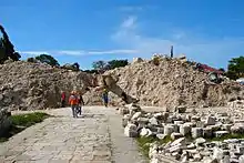 The rubble that was Loon Church after the quake
 Animation of before and after the 2013 earthquake Assunta de la Nuestra Sra. Parish Church, Dauis, Bohol
.jpg.webp) San Isidro Labrador Parish Church, Tubigon, Bohol (Before and After 2013 Bohol Earthquake)
San Isidro Labrador Parish Church, Tubigon, Bohol (Before and After 2013 Bohol Earthquake).jpg.webp) Inmaculada Concepcion Parish Church, Baclayon, Bohol (Before and After 2013 Bohol Earthquake)
Inmaculada Concepcion Parish Church, Baclayon, Bohol (Before and After 2013 Bohol Earthquake).jpg.webp) Santa Cruz Parish Church, Maribojoc, Bohol (Before and After 2013 Bohol Earthquake)
Santa Cruz Parish Church, Maribojoc, Bohol (Before and After 2013 Bohol Earthquake).jpg.webp) San Pedro Apostol Parish Church, Loboc, Bohol (Before and After 2013 Bohol Earthquake)
San Pedro Apostol Parish Church, Loboc, Bohol (Before and After 2013 Bohol Earthquake).jpg.webp) Nuestra Sra. de la Luz Parish Church, Loon, Bohol (Before and After 2013 Bohol Earthquake)
Nuestra Sra. de la Luz Parish Church, Loon, Bohol (Before and After 2013 Bohol Earthquake).jpg.webp) Assunta de la Nuestra Sra. Parish Church, Dauis, Bohol (Before and After 2013 Bohol Earthquake)
Assunta de la Nuestra Sra. Parish Church, Dauis, Bohol (Before and After 2013 Bohol Earthquake)
- A magnitude 6.1 quake struck 47 km N 47°E of Burgos (Surigao del Norte) on July 3, 2015, 2:43 pm at a depth of 26 km. One person died of a heart attack in Balingasag and minor damage was observed in Del Carmen, Surigao del Norte.[89][90][91]
- A magnitude 6.5 earthquake struck 10 km SW of Basilisa, Dinagat Islands on February 10, 2017, 10:03 pm at a depth of 15 km. Eight people were killed and 202 injured.[92]
- Batangas experienced an earthquake swarm in April 2017. A magnitude 5.5 earthquake struck 5 km W of Batangas on April 4, 2017, 8:58 pm at a depth of 82 km. Twin earthquakes with magnitudes of 5.6 and 6.0 hit the barangays of Bagalangit and Tanauan, both in Mabini, Batangas respectively on April 8, 2017, 3:07 and 3:09 pm at a depth of 40.4 km. Damage on some buildings and houses wasa reported. Several aftershocks followed.
- A magnitude 6.9 earthquake struck 47 km S 26° W of Sarangani and Davao Occidental provinces on April 29, 2017, at 4:23 am at a depth of 57 km. Five people were injured.[93]
- A magnitude 6.5 earthquake struck 3 km S 16° E of Jaro, Leyte on July 6, 2017, at 4:03 pm at a depth of 8 km. It caused island-wide blackouts in the provinces of Samar, Bohol, Leyte, and parts of Southern Leyte In Kananga, a commercial building collapsed killing two persons and injuring 20 others. In Ormoc City, a landslide was triggered. Four people died and 100 others were injured.[94]
- A magnitude 6.1 earthquake struck Central Luzon (with epicenter in Castillejos, Zambales) on April 22, 2019, at 5:11 pm.[95] Widespread damage was also caused in Pampanga Province, 18 people were killed and 282 others injured.[96]
- A magnitude 6.4 earthquake struck Eastern Visayas (Eastern Samar) on April 23, 2019, at 1:37 pm.[97] 48 people were injured, most of them slightly by falling objects.[98]
- A magnitude 5.6 earthquake struck Makilala, Cotabato on July 9, 2019, at 8:36 pm local time, leaving 1 dead and 73 injured.[99]
- A twin magnitude 5.4 and 5.9 earthquake struck off east of Itbayat, Batanes on July 27, 2019.[100][101] The first tremor occurred at 4:16 am at a depth of 12 km and the second tremor occurred at 7:37 am at a depth of 21 km. The twin quakes destroyed several structures in Itbayat.[102] 9 people were confirmed dead while 60 people are injured.[103]
.jpg.webp) Damaged Itbayat Church after the 2019 Batanes earthquake
Damaged Itbayat Church after the 2019 Batanes earthquake - A magnitude of 6.3 earthquake struck Tulunan, Cotabato on October 16, 2019, around 7:37 pm.[104] Seven people were reported dead and more than 200 others injured. Most of the houses in Brgy. Malawanit Magsaysay, Davao del Sur, were destroyed. The aftermath left frequent aftershocks extended to over a week on random cycles.[105]
- A magnitude of 6.6 earthquake again struck in Tulunan, Cotabato on October 29, 2019, with some reports stating that this earthquake felt much devastating as the previous earthquake that took place on October 16, 2019.[106] Nearby towns such as those in Kidapawan, North Cotabato and Davao city were also affected.
- A magnitude 6.5 earthquake struck Tulunan, Cotabato for the third time on October 31, 2019, Death toll amongst towns and cities nearby has increased; CNN Philippines reporting increased fatal casualties risen to 10 during live news broadcast. Revised body count reports 24 fatal casualties in total including the numbers from the two consecutive earthquakes that took place on October 29 and 31, with more than 500 people being injured and three reported missing.[107]
- A magnitude 6.8 earthquake struck Matanao, Davao del Sur on December 15, 2019, at 2:11 pm. 13 people were killed, one remains missing and 210 others were injured during this tremor.[108]

- A magnitude 6.6 earthquake struck Cataingan, Masbate on August 18, 2020, at 8:03 am. Two people were killed and at least 170 people were injured.[109]
- A magnitude 6.1 earthquake struck Magsaysay, Davao del Sur on February 7, 2021, at 12:22 pm. 14 people were injured after the earthquake.[110]
- A magnitude 6.6 earthquake struck off the coast of Calatagan, Batangas on July 24, 2021, at 4:49 a.m. (PhST). A 5.5 magnitude aftershock struck off the same area shortly afterward. PHIVOLCS also reported several aftershocks with magnitudes ranging from 1.7 to 3 hours later. The earthquake caused a landslide in Calatagan and damaged houses in Lubang, Occidental Mindoro.[111]
- A magnitude 7.1 earthquake struck off the coast of Governor Generoso, Davao Oriental on August 12, 2021, at 1:46 a.m. (PhsT). PHIVOLCS reported earlier that the epicenter was located off the coast of Mati City in Davao Oriental, with a 7.3 magnitude. No major damage reported so far.[112] A 20-year-old man died after being hit by falling coconuts in Tandag City, Surigao del Sur.[113]
- A magnitude 7.0 earthquake struck the province of Abra in the Cordillera Administrative Region on July 27, 2022.[114] PHIVOLCS reported the epicenter at 17.64°N, 120.63°E - 003 km N 45° W of Tayum (Abra) at a depth of 17 kilometers. Tremors were felt in Northern and Central Luzon including Metro Manila and adjacent provinces.[115]
- A magnitude 6.0 earthquake struck the province of Davao de Oro in the Davao Region on February 1, 2023.[116] PHIVOLCS reported the epicenter at 7.66°N, 126.07°E - 002 km S 66° W of New Bataan (Davao de Oro) at a depth of 17 kilometers.[117] Sixteen people were injured and 52 buildings were damaged.[118]
Deadliest earthquakes
| Ten deadliest recorded earthquakes in the Philippines since the 1600s | |||||||||
|---|---|---|---|---|---|---|---|---|---|
| Magnitude | Location | Date | Deaths | Missing | Injured | Damage | Source | ||
| 1 | 8.0 | Moro Gulf | August 16, 1976 | 4,791 | 2,288 | 9,928 | |||
| 2 | 7.8 | Luzon Island | July 16, 1990 | 1,621 | 1,000 | >3,000 | ₱ 10 billion | ||
| 3 | Unknown | Manila | June 3, 1863 | 1,000 | [1] | ||||
| 4 | 7.5 | Luzon Island | November 30, 1645 | >600 | >3,000 | Unknown | |||
| 5 | 8.1 | Mati, Davao Oriental | April 14, 1924 | ~500 | [119][120] | ||||
| 6 | 7.4 | Lanao del Sur | April 1, 1955 | >400 | Unknown | US$5 million | [121] | ||
| 7 | 7.6 | Casiguran, Aurora | August 2, 1968 | 271 | 261 | ||||
| 8 | 7.2 | Bohol and Cebu | October 15, 2013 | 222 | 8 | 796 | ₱ 4 billion (est.) | [122] | |
| 9 | 6.7 | Negros Oriental | February 6, 2012 | 51 | 62 | 112 | ₱ 383 million | ||
| 10 | 7.1 | Mindoro | November 15, 1994 | 78 | 430 | ₱ 5.15 million | [31] | ||
See also
References
- "The Project Gutenberg eBook of Catalogue of Violent and Destructive Earthquakes in the Philippines, by Rev. Miguel Saderra Masó, S.J." www.gutenberg.org. Retrieved July 29, 2022.
- "M 6.7 – Luzon, Philippines". United States Geological Survey. Retrieved March 15, 2018.
- "M 7.5 – Philippine Islands region". United States Geological Survey. Retrieved March 15, 2018.
- "M 6.4 – Philippine Islands region". United States Geological Survey. Retrieved March 15, 2018.
- "M 6.7 – Philippine Islands region". United States Geological Survey. Retrieved March 15, 2018.
- "M 7.3 – Luzon, Philippines". United States Geological Survey. Retrieved April 22, 2019.
- "M 7.4 – Mindoro, Philippines". United States Geological Survey. Retrieved March 15, 2018.
- "M 7.5 – Mindoro, Philippines". United States Geological Survey. Retrieved March 15, 2018.
- "June 1999 Earthquakes in Agusan del Sur, Philippines". Philippine Institute of Volcanology and Seismology. Archived from the original on March 6, 2022. Retrieved February 7, 2012.
- "M 8.0 – Mindanao, Philippines". USGS. Archived from the original on March 4, 2016. Retrieved August 26, 2018.
- "Significant Earthquake: PHILIPPINES: E MINDANAO: MATI,SURIGA". National Geophysical Data Center. April 14, 1924. Retrieved January 3, 2016.
- "UPDATES: PHIVOLCS WARNS OF DAVAO 'KILLER QUAKE'". Durianburg Davao. June 19, 2015. Retrieved June 30, 2022.
- "FAST BACKWARD: Greatest quakes in PH history". Edge Davao. March 1, 2017. Retrieved June 30, 2022.
- "Luzon Island Shaken By Major Earthquake". Evening Independent. December 29, 1949. Archived from the original on March 8, 2022. Retrieved March 15, 2012.
- "M 7.8 – Mindanao, Philippines". United States Geological Survey. 1913.
- "M 8.3 – Mindanao, Philippines". United States Geological Survey. 1918.
- "M 8.0 – Mindanao, Philippines". United States Geological Survey. 1924.
- "M 7.8 – Mindanao, Philippines". United States Geological Survey. 1943.
- "M 8.0 – Mindanao, Philippines". United States Geological Survey. 1972.
- "M 7.9 – Mindanao, Philippines". United States Geological Survey. 1976.
- "6 Dead in Manila in a Major Quake; Scores Injured". The New York Times. April 8, 1970. Archived from the original on March 29, 2018. Retrieved February 18, 2022.
- "Minimal quake damage due to several factors". Philippine Daily Inquirer. October 1, 2012. Archived from the original on October 6, 2012. Retrieved February 18, 2022.
- "Today in Earthquake History". USGS Earthquake Hazards Program. Archived from the original on February 18, 2022. Retrieved February 18, 2022.
- "Ragay Gulf Earthquake – 17 March 1973". Philippine Institute of Volcanology and Seismology. Archived from the original on February 19, 2022. Retrieved February 7, 2012.
- "Historic World Earthquakes – Philippines". United States Geological Survey. Archived from the original on July 28, 2010. Retrieved February 7, 2012.
- "Laoag Earthquake – 17 August 1983". Philippine Institute of Volcanology and Seismology. Archived from the original on October 22, 2013. Retrieved February 7, 2012.
- "M 6.2 - 1 km NNE of Bagong Sikat, Philippines-Impact". USGS. Archived from the original on March 9, 2022. Retrieved March 8, 2022.
- "Bohol Earthquake – February 8, 1990". Philippine Institute of Volcanology and Seismology. Archived from the original on October 22, 2013. Retrieved February 7, 2012.
- "Panay Earthquake – 14 June 1990". Philippine Institute of Volcanology and Seismology. Archived from the original on July 23, 2015. Retrieved February 7, 2012.
- Punongbayan, Raymundo S. et al. (Philippine Institute of Volcanology and Seismology); and Takashi Nakata, Hiroyuki Tsutsumi (Hiroshima University, Japan). "The 16 July 1990 Luzon Earthquake Ground Rupture". Philippine Institute of Volcanology and Seismology. Archived from the original on July 23, 2015. Retrieved February 7, 2012.
{{cite web}}: CS1 maint: multiple names: authors list (link) - "1994 Mindoro Tsunami". Philippine Institute of Volcanology and Seismology. Archived from the original on March 8, 2004. Retrieved February 7, 2012.
- "Today in Earthquake History". USGS. Archived from the original on February 18, 2022. Retrieved February 18, 2022.
- "Samar Island, Philippines Earthquakes and Tsunami of April 21, 1995" (PDF). Tsunami Newsletter. Honolulu, Hawaii: International Tsunami Information Center. July 1995. Archived (PDF) from the original on March 9, 2022. Retrieved August 26, 2018.
- "Bohol Earthquake – 27 May 1996". Philippine Institute of Volcanology and Seismology. Archived from the original on November 17, 2015. Retrieved February 7, 2012.
- "Philippines – Earthquake OCHA Situation Report No. 2". reliefweb. Archived from the original on October 15, 2013. Retrieved August 31, 2018.
- "M 7.5 – Mindanao, Philippines". United States Geological Survey. Archived from the original on June 26, 2015. Retrieved March 8, 2018.
- "M 6.4 – Mindanao, Philippines". United States Geological Survey. Archived from the original on March 9, 2018. Retrieved March 8, 2018.
- "M 6.4 – Philippine Islands region". United States Geological Survey. Archived from the original on December 29, 2018. Retrieved March 8, 2018.
- "M 6.6 – 106km WSW of Sangay, Philippines". United States Geological Survey. Archived from the original on May 26, 2016. Retrieved December 2, 2014.
- "M 6.1 – 23km NW of Santa Monica, Philippines". United States Geological Survey. Archived from the original on July 4, 2015. Retrieved July 4, 2015.
- "M 6.3 – 36km SE of Tamisan, Davao Region, Philippines". United States Geological Survey. Archived from the original on September 24, 2016. Retrieved November 15, 2016.
- "M 6.9 – 31km SW of Burias, Philippines". United States Geological Survey. Archived from the original on January 4, 2019. Retrieved January 4, 2019.
- National Earthquake Information Center (February 1, 2023). "M 6.0 - Mindanao, Philippines". United States Geological Survey.
- "Philippines: Mindanao Earthquake, 2001". National Geophysical Data Center. Archived from the original on April 14, 2013. Retrieved February 7, 2012.
- "Magnitude 7 and Greater Earthquakes in 2002". United States Geological Survey. Archived from the original on February 18, 2012. Retrieved February 7, 2012.
- "Poster of the Mindanao, Philippines Earthquake of 05 March 2002 – Magnitude 7.5". United States Geological Survey. Archived from the original on June 7, 2011. Retrieved February 7, 2012.
- "Palimbang Earthquake: Summary Report". Philippine Institute of Volcanology and Seismology. Archived from the original on November 17, 2015. Retrieved February 7, 2012.
- "Masbate Earthquake: Report of Investigation". Philippine Institute of Volcanology and Seismology. Archived from the original on August 25, 2013. Retrieved February 7, 2012.
- "Quake kills 1, leaves Eastern Samar powerless". Philippine Daily Inquirer. Archived from the original on November 25, 2003. Retrieved February 28, 2022.
- "M 6.5 - 4 km NW of Can-Avid, Philippines - Impact". USGS. Archived from the original on February 28, 2022. Retrieved February 28, 2022.
- "Strong quake jolts E. Samar; boy killed, buildings collapse". Philstar. Archived from the original on March 1, 2022. Retrieved March 1, 2022.
- "M 5.7 - 3 km NE of San Miguel, Philippines (Impact)". USGS. Archived from the original on March 1, 2022. Retrieved March 1, 2022.
- "Situation report on the effects of earthquake in South Cotabato Province" (PDF). Reliefweb. Archived (PDF) from the original on March 1, 2022. Retrieved March 1, 2022.
- "Earthquake Information No. 5". Philippine Institute of Volcanology and Seismology. Archived from the original on February 1, 2012. Retrieved February 7, 2012.
- "39 hurt in Bukidnon quake". ABS-CBN News. November 8, 2011. Retrieved February 6, 2012.
- Abigail Kwok; Joseph Ubalde & Lira Dalangin-Fernandez (February 6, 2012). "Number of casualties rises as 6.9 quake strikes off Negros". Interaksyon. Archived from the original on February 9, 2012. Retrieved February 7, 2012.
- Ellalyn B. De Vera; Elena L. Aben & Mars W. Mosqueda Jr. (February 6, 2012). "Quake Jolts Visayas". Manila Bulletin. Archived from the original on February 9, 2012. Retrieved February 6, 2012.
- "Strong quake jolts Negros-Cebu; fatalities rising". ABS-CBN News. February 6, 2012. Archived from the original on February 6, 2012. Retrieved February 6, 2012.
- "5.9-magnitude quake sparks stampede in Surigao". SunStar. March 16, 2012. Archived from the original on March 18, 2012. Retrieved September 4, 2012.
- "Phivolcs: Magnitude-5.9 quake hits Surigao area, damage and aftershocks expected". GMA News. GMA Network. March 16, 2012. Archived from the original on March 4, 2016. Retrieved September 4, 2012.
- "Quake leads to stampede at Surigao mall". Rappler. March 16, 2012. Archived from the original on March 17, 2012. Retrieved September 4, 2012.
- Cerojano, Teresa (September 1, 2012). "Quake off Philippines spurs small tsunami; 1 dead". Associated Press. Archived from the original on September 4, 2012. Retrieved September 4, 2012.
- "One dead as 7.6-magnitude quake hits Philippines". The Philippine Star. September 1, 2012. Archived from the original on October 15, 2013. Retrieved September 4, 2012.
- "Quake damages 77 homes in E. Samar town". ABS-CBN News. September 1, 2012. Retrieved September 4, 2012.
- "Quake severely damages E. Samar hospital". ABS-CBN News. September 4, 2012. Retrieved September 4, 2012.
- "Quake causes panic, damage in Visayas, Mindanao". ABS-CBN News. September 1, 2012. Archived from the original on September 2, 2012. Retrieved September 4, 2012.
- "Strong quake, but minimal effects: gov't". The Philippine Star. Xinhua. September 2, 2012. Archived from the original on October 15, 2013. Retrieved September 4, 2012.
- "Philippine families rebuild amid further quake fears". Business Recorder. Agence France-Presse. September 2, 2012. Archived from the original on October 14, 2013. Retrieved September 4, 2012.
- "At least 1 dead in 7.6 Philippine quake, small tsunami reported, warning canceled". Fox News. Associated Press. August 31, 2012. Archived from the original on January 5, 2019. Retrieved September 4, 2012.
- "Earthquake Information: September 3, 2012 06:48:49 PM". Philippine Institute of Volcanology and Seismology. Archived from the original on September 24, 2015. Retrieved February 7, 2012.
- "Earthquake Information: September 3, 2012 07:45:48 PM". Philippine Institute of Volcanology and Seismology. Archived from the original on September 24, 2015. Retrieved February 7, 2012.
- "Earthquake Information: September 3, 2012 09:21:04 PM". Philippine Institute of Volcanology and Seismology. Archived from the original on September 24, 2015. Retrieved February 7, 2012.
- "Earthquake Information: September 4, 2012 03:44:22 AM". Philippine Institute of Volcanology and Seismology. Retrieved February 7, 2012.
- "Earthquake Information: September 4, 2012 03:52:26 AM". Philippine Institute of Volcanology and Seismology. Retrieved February 7, 2012.
- "5.6 quake jolts Bukidnon, nearby provinces". The Philippine Star. September 4, 2012. Retrieved September 4, 2012.
- Mangosing, Frances (September 4, 2012). "5.6-magnitude quake shakes Bukidnon". Philippine Daily Inquirer. Retrieved September 4, 2012.
- "Nun injured; 144 structures, houses destroyed in Bukidnon quakes". Bukidnon News. September 4, 2012. Archived from the original on February 21, 2013. Retrieved September 4, 2012.
- "Initial Report re Effects of Earthquake in Maramag, Bukidnon" (PDF). National Disaster Risk Reduction and Management Council. February 18, 2012. p. 17. Archived from the original (PDF) on October 17, 2012. Retrieved February 19, 2012.
- "Strong quake jolts Cotabato". Sun Star Davao. June 1, 2013. Retrieved June 3, 2013.
- Frances Mangosing (June 1, 2013). "5.7-quake shakes Mindanao—Phivolcs". Philippine Daily Inquirer. Retrieved June 3, 2013.
- "Magnitude 5.7 quake felt in several Mindanao areas". MindaNews. June 2, 2013. Retrieved June 3, 2013.
- Jasper Acosta (June 2, 2013). "Quake destroys 30 houses in Carmen, N. Cotabato". ABS-CBN News. Retrieved June 2, 2013.
- Keith Bacongco (June 2, 2013). "5 injured in Saturday's magnitude 5.7 quake; 30 houses partly destroyed". MindaNews. Retrieved June 3, 2013.
- Edwin Fernandez (June 3, 2013). "Classes in quake-hit North Cotabato town suspended". Philippine Daily Inquirer. Retrieved June 3, 2013.
- Alexander D. Lopez (June 2, 2013). "Magnitude 5.7 quake hits North Cotabato". Manila Bulletin. Retrieved June 3, 2013.
- John Unson (June 3, 2013). "P71M worth of properties damaged in Cotabato quake". The Philippine Star. Retrieved June 3, 2013.
- Malu Cadelina Manar (June 3, 2013). "DepEd suspends classes in quake-affected town of Carmen". Manila Bulletin. Retrieved June 3, 2013.
- Frances Mangosing (October 15, 2013). "Death toll from Bohol quake jumps to 85". Philippine Daily Inquirer. Retrieved October 15, 2013.
- "003 km N 59° e of Kananga (Leyte) Information No. 2".
- "M 6.1 - 23 km NW of Santa Monica, Philippines". USGS. Retrieved March 2, 2022.
- "Earthquake hits parts of Mindanao, Eastern Visayas". Rappler. Retrieved March 2, 2022.
- "Aftershocks rattle survivors after Philippine quake kills 8". Fox News. February 12, 2017. Retrieved October 1, 2017.
- "Update on Sitrep No.02 re Magnitude 7.2 Earthquake in Sarangani, Davao Occidental, Issued on 30 April 2017" (PDF). National Disaster Risk Reduction and Management Council. April 30, 2017. Retrieved December 16, 2019.
- Correspondent, Barbara Mae Dacanay (July 8, 2017). "Four dead, 100 injured in Leyte's 6.5 magnitude quake". GulfNews. Retrieved October 1, 2017.
- "Magnitude 6.1 earthquake rocks Luzon". Rappler. April 22, 2019.
- "18 dead, over 280 injured in Central Luzon due to quake – NDRRMC". GMA News. Retrieved April 25, 2019.
- "M 6.4 – 17km ESE of Tutubigan, Philippines". earthquake.usgs.gov. Retrieved April 23, 2019.
- National Disaster Risk Reduction and Management Council (April 30, 2019). "NDRRMC Update:SitRep No.09 re Magnitude 6.5 Earthquake in San Julian, Eastern Samar" (PDF). Retrieved December 16, 2019.
- "Magnitude-5.6 quake hits North Cotabato". ABS-CBN News. July 9, 2019. Retrieved September 6, 2021.
- "Magnitude 5.4 earthquake hits Itbayat, Batanes". GMA News. July 27, 2019.
- "Magnitude 5.9 quake rocks Batanes". ABS-CBN News. July 27, 2019.
- "LOOK: Itbayat church, ancestral homes damaged in Batanes earthquake". Rappler. July 27, 2019.
- Cataluña, Juliet. "Some Batanes quake fatalities buried immediately". Philippine Daily Inquirer. Retrieved July 27, 2019.
- Armand Vervaeck (October 16, 2019). "Very dangerous earthquake in Mindanao, Philippines – October 16, 2019". Earthquake-Report.com. Retrieved October 30, 2019.
- National Disaster Risk Reduction and Management Council (October 21, 2019). "NDRRMC Update: Situational Report No,09 regarding Magnitude 6.3 in Tulunan, NOrth Cotabato" (PDF). Retrieved December 16, 2019.
- "Phivolcs: October 16 quake a foreshock to October 29 tremor". ABS-CBN News. Retrieved October 30, 2019.
- "NDRRMC Update: SitRep No.23 regarding Magnitude 6.6 and 6.5 Earthquakes in Tulunan, North Cotabato" (PDF). November 13, 2019. Retrieved December 16, 2019.
- National Disaster Risk Reduction and Management Council (December 22, 2019). "NDRRMC Update: SitRep No. 12 regarding Magnitude 6.9 Earthquake in Matanao, Davao del Sur (Region XI)" (PDF). Retrieved December 22, 2019.
- "Masbate quake death toll rises to 2, hundreds injured as aftershocks rock Cataingan town". cnn. Retrieved August 20, 2020.
- Ropero, Gillan (February 7, 2021). "Magnitude 6.1 quake rocks Davao del Sur". ABS-CBN News. Retrieved September 6, 2021.
- "Magnitude 6.6 earthquake hits off Batangas province". ABS-CBN News. July 24, 2021.
- "Magnitude 7.1 quake shakes Governor Generoso in Davao Oriental, nearby provinces". GMA News. August 12, 2021. Retrieved August 12, 2021.
- Alexander Lopez (August 13, 2021). "Fallen coconuts from strong quake kill man in Tandag City". pna.gov.ph. Retrieved August 13, 2021.
- "Magnitude 7.3 earthquake hits Abra". Rappler. July 27, 2022. Retrieved July 27, 2022.
- "Philippines: Abra Earthquake - Flash Update No. 1 (As of 27 July 2022, 9 p.m. local time) - Philippines | ReliefWeb". reliefweb.int. Retrieved July 29, 2022.
- "Magnitude 6 earthquake rocks Davao region". ABS-CBN News. February 2, 2023. Retrieved February 3, 2023.
- "EARTHQUAKE INFORMATION NO. : 4". phivolcs.dost.gov.ph. Retrieved February 3, 2023.
- "16 injured in Davao de Oro quake". newsinfo.inquirer.net. February 3, 2023. Retrieved February 3, 2023.
- durianburgdavao (June 19, 2015). "UPDATES: PHIVOLCS WARNS OF DAVAO 'KILLER QUAKE'". THE DURIAN POST. Retrieved August 2, 2022.
- "M 8.1 - 6 km E of Tibanbang, Philippines". earthquake.usgs.gov. Retrieved August 2, 2022.
- NCEI. "Global Significant Earthquake Database, 2150 B.C. to present". NOAA National Centers for Environmental Information.
- "Massive extremely dangerous earthquake in Bohol, Philippines – At least 222 people killed, 8 missing, over 790 injured, around 4 billion PHP damage, 7 billion PHP reconstruction costs". Earthquake-Report.com. November 14, 2013. Archived from the original on November 26, 2013. Retrieved December 16, 2019.
External links
- Official website of the Philippine Institute of Volcanology and Seismology Archived January 29, 2010, at the Wayback Machine
- Latest Earthquake Bulletin in the Philippines
- Official website of the National Disaster Risk Reduction and Management Council
List of earthquakes in Asia | |
|---|---|
| Sovereign states |
|
| States with limited recognition |
|
| Dependencies and other territories |
|
| |