Dobrovítov
Dobrovítov is a municipality and village in Kutná Hora District in the Central Bohemian Region of the Czech Republic. It has about 100 inhabitants.
Dobrovítov | |
|---|---|
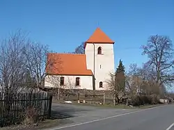 Church of Saint Wenceslaus | |
 Dobrovítov Location in the Czech Republic | |
| Coordinates: 49°47′15″N 15°19′44″E | |
| Country | |
| Region | Central Bohemian |
| District | Kutná Hora |
| First mentioned | 1355 |
| Area | |
| • Total | 9.01 km2 (3.48 sq mi) |
| Elevation | 487 m (1,598 ft) |
| Population (2023-01-01)[1] | |
| • Total | 128 |
| • Density | 14/km2 (37/sq mi) |
| Time zone | UTC+1 (CET) |
| • Summer (DST) | UTC+2 (CEST) |
| Postal code | 286 01 |
| Website | www |
Administrative parts
The village of Dědice is an administrative part of Dobrovítov.
Geography
Dobrovítov is located about 19 kilometres (12 mi) south of Kutná Hora and 64 km (40 mi) southeast of Prague. It lies in the Upper Sázava Hills. The highest point is at 551 m (1,808 ft) above sea level. The Klejnárka River flows through the municipality.
History
The first written mention of Dobrovítov is from 1355.[2]
Sights
The main landmark of Dobrovítov is the Church of Saint Wenceslaus. It was probably founded at the beginning of the 14th century. The Renaissance tower was added after 1581. Further modifications were made after 1720.[3]
References
- "Population of Municipalities – 1 January 2023". Czech Statistical Office. 2023-05-23.
- "Historie" (in Czech). Obec Dobrovítov. Retrieved 2022-09-13.
- "Kostel sv. Václava" (in Czech). National Heritage Institute. Retrieved 2023-06-30.
This article is issued from Wikipedia. The text is licensed under Creative Commons - Attribution - Sharealike. Additional terms may apply for the media files.