Domažlice District
Domažlice District (Czech: okres Domažlice) is a district in the Plzeň Region of the Czech Republic. Its capital is the town of Domažlice.
Domažlice District
Okres Domažlice | |
|---|---|
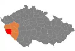 Location in the Plzeň Region within the Czech Republic | |
| Coordinates: 49°30′N 12°54′E | |
| Country | |
| Region | Plzeň |
| Capital | Domažlice |
| Area | |
| • Total | 1,051.84 km2 (406.12 sq mi) |
| Population (2023)[2] | |
| • Total | 55,796 |
| • Density | 53/km2 (140/sq mi) |
| Time zone | UTC+1 (CET) |
| • Summer (DST) | UTC+2 (CEST) |
| Municipalities | 76 |
| * Towns | 7 |
| * Market towns | 3 |
Administrative division
Domažlice District is divided into two administrative districts of municipalities with extended competence: Domažlice and Horšovský Týn.
List of municipalities
Towns are marked in bold and market towns in italics:
Babylon - Bělá nad Radbuzou - Blížejov - Brnířov - Čermná - Česká Kubice - Chocomyšl - Chodov - Chodská Lhota - Chrastavice - Díly - Domažlice - Drahotín - Draženov - Hlohová - Hlohovčice - Hora Svatého Václava - Horšovský Týn - Hostouň - Hradiště - Hvožďany - Kanice - Kaničky - Kdyně - Klenčí pod Čerchovem - Koloveč - Kout na Šumavě - Křenovy - Libkov - Loučim - Luženičky - Meclov - Mezholezy (former Domažlice District) - Mezholezy (former Horšovský Týn District) - Milavče - Mířkov - Mnichov - Močerady - Mrákov - Mutěnín - Nemanice - Němčice - Nevolice - Nová Ves - Nový Kramolín - Osvračín - Otov - Pařezov - Pasečnice - Pec - Pelechy - Poběžovice - Pocinovice - Poděvousy - Postřekov - Puclice - Rybník - Semněvice - Spáňov - Srbice - Srby - Staňkov - Stráž - Tlumačov - Trhanov - Úboč - Újezd - Únějovice - Úsilov - Velký Malahov - Vidice - Vlkanov - Všepadly - Všeruby - Zahořany - Ždánov
Geography
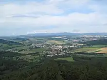
Domažlice District borders Germany in the west. The terrain is hilly and along the state border, the landscape is mountainous. The territory extends into five geomorphological mesoregions: Upper Palatine Forest (west), Upper Palatine Forest Foothills (north and centre), Plasy Uplands (northeast), Cham-Furth Depression (south) and Švihov Highlands (east). The highest point of the district is the mountain Čerchov in Pec with an elevation of 1,042 m (3,419 ft). The lowest point is the river bed of the Radbuza in Staňkov at 351 m (1,152 ft).
From the total district area of 1,051.8 km2 (406.1 sq mi), agricultural land occupies 564.2 km2 (217.8 sq mi), forests occupy 396.7 km2 (153.2 sq mi), and water area occupies 12.9 km2 (5.0 sq mi). Forests cover 37.7% of the district's area.[1]
The only important river is the Radbuza, which springs in the western part of the district and flows across the district to east. The Chamb also springs here. There are no large bodies of water in the territory. The largest is the Mezholezský Pond with an area of 38 ha (94 acres).[3]
There is one protected landscape area: the southern half of Český les.
Demographics
|
|
| ||||||||||||||||||||||||||||||||||||||||||||||||||||||
| Source: Censuses[4][5][lower-alpha 1] | ||||||||||||||||||||||||||||||||||||||||||||||||||||||||
Most populated municipalities
| Name | Population[2] | Area (km2) |
|---|---|---|
| Domažlice | 11,010 | 25 |
| Kdyně | 5,235 | 29 |
| Horšovský Týn | 5,132 | 71 |
| Staňkov | 3,388 | 21 |
| Bělá nad Radbuzou | 1,718 | 83 |
| Blížejov | 1,620 | 25 |
| Poběžovice | 1,526 | 28 |
| Klenčí pod Čerchovem | 1,452 | 18 |
| Hostouň | 1,234 | 39 |
| Meclov | 1,208 | 32 |
Economy
The largest employers with headquarters in Domažlice District and at least 500 employees are:[6]
| Economic entity | Location | Number of employees | Main activity |
|---|---|---|---|
| Trans World Hotels & Entertainment | Česká Kubice | 500–999 | Gambling and betting activities |
| Domažlice Hospital | Domažlice | 500–999 | Health care |
| Gerresheimer Horšovský Týn | Horšovský Týn | 500–999 | Manufacture of plastic products |
Transport
There are no motorways passing through the district. The most important road is the I/26 from Plzeň to the Czech-German border via Horšovský Týn.
Sights
The most important monuments in the district, protected as national cultural monuments, are:[7]
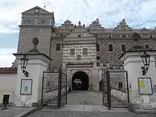
- Horšovský Týn Castle
- Augustinian monastery in Mnichov-Pivoň
The best-preserved settlements, protected as monument reservations and monument zones, are:[8]
- Domažlice (monument reservation)
- Horšovský Týn (monument reservation)
- Poběžovice
- Kanice
- Klenčí pod Čerchovem
- Pocinovice
- Stráž
- Trhanov
The most visited tourist destination is the Horšovský Týn Castle.[9]
Notable people
Notes
References
- "Land use (as at 31 December)". Public database. Czech Statistical Office. Retrieved 2023-05-19.
- "Population of Municipalities – 1 January 2023". Czech Statistical Office. 2023-05-23.
- "Registr ekonomických subjektů" (in Czech). Obec Mezholezy. Retrieved 2023-02-17.
- "Historický lexikon obcí České republiky 1869–2011 – Okres Domažlice" (in Czech). Czech Statistical Office. 2015-12-21. pp. 1–2.
- "Population Census 2021: Population by sex". Public Database. Czech Statistical Office. 2021-03-27.
- "Registr ekonomických subjektů". Business Register (in Czech). Czech Statistical Office. Retrieved 2023-02-17.
- "Výsledky vyhledávání: Národní kulturní památky, okres Domažlice". Ústřední seznam kulturních památek (in Czech). National Heritage Institute. Retrieved 2023-02-17.
- "Výsledky vyhledávání: Památkové rezervace, Památkové zóny, okres Domažlice". Ústřední seznam kulturních památek (in Czech). National Heritage Institute. Retrieved 2023-02-17.
- "Návštěvnost památek 2021" (in Czech). Národní informační a poradenské středisko pro kulturu. Retrieved 2023-02-17.
External links
- Domažlice District – profile on the Czech Statistical Office website