Donnelly, Alberta
Donnelly is a village in northern Alberta, Canada within the Municipal District of Smoky River No. 130. It is located near the intersection of Highway 2 and Highway 49, located approximately 65 km (40 mi) south of Peace River and 427 km (265 mi) northwest of Edmonton.
Donnelly | |
|---|---|
| Village of Donnelly | |
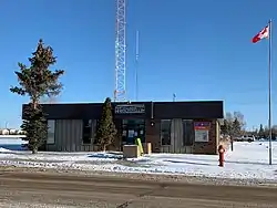
 Post Office in Donnelly, Alberta | |
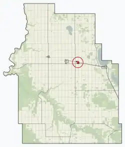
 Location in M.D. of Smoky River | |
 Donnelly Location in Alberta | |
| Coordinates: 55°43′22.2″N 117°06′16.9″W | |
| Country | Canada |
| Province | Alberta |
| Region | Northern Alberta |
| Planning region | Upper Peace |
| Municipal district | Smoky River |
| Incorporated[1] | |
| • Village | January 1, 1956 |
| Government | |
| • Mayor | Myrna Lanctot |
| • Governing body | Donnelly Village Council |
| Area (2021)[3] | |
| • Land | 1.26 km2 (0.49 sq mi) |
| Elevation | 595 m (1,952 ft) |
| Population (2021)[3] | |
| • Total | 338 |
| • Density | 269/km2 (700/sq mi) |
| Time zone | UTC−7 (MST) |
| • Summer (DST) | UTC−6 (MDT) |
| Highways | Highway 2 Highway 49 |
| Website | Official website |
History
In 1912, a group of 14 settlers from Grouard arrived in the Donnelly area. Marie-Anne Leblanc Gravel was first homesteader.[4]
The community was named after one Mr. Donnelly, a railroad employee.[5]
Demographics
In the 2021 Census of Population conducted by Statistics Canada, the Village of Donnelly had a population of 338 living in 154 of its 185 total private dwellings, a change of -5.8% from its 2016 population of 359. With a land area of 1.26 km2 (0.49 sq mi), it had a population density of 268.3/km2 (694.8/sq mi) in 2021.[3]
In the 2016 Census of Population conducted by Statistics Canada, the Village of Donnelly recorded a population of 342 living in 150 of its 170 total private dwellings, a 12.1% change from its 2011 population of 305. With a land area of 1.31 km2 (0.51 sq mi), it had a population density of 261.1/km2 (676.2/sq mi) in 2016.[13]
Transportation
Donnelly is served by the Donnelly Airport (IATA: YOE, TC LID: CFM4).
References
- "Location and History Profile: Village of Donnelly" (PDF). Alberta Municipal Affairs. October 14, 2016. p. 246. Retrieved October 17, 2016.
- "Municipal Officials Search". Alberta Municipal Affairs. May 9, 2019. Retrieved October 1, 2021.
- "Population and dwelling counts: Canada, provinces and territories, and census subdivisions (municipalities)". Statistics Canada. February 9, 2022. Retrieved February 9, 2022.
- Sanderson, Kay (1999). 200 Remarkable Alberta Women. Calgary: Famous Five Foundation. p. 33.
- Place-names of Alberta. Ottawa: Geographic Board of Canada. 1928. p. 43.
- "Table 6: Population by sex, for census subdivisions, 1956 and 1951". Census of Canada, 1956. Vol. I: Population. Ottawa: Dominion Bureau of Statistics. 1958.
- "Table 9: Population by census subdivisions, 1966 by sex, and 1961". 1966 Census of Canada. Western Provinces. Vol. Population: Divisions and Subdivisions. Ottawa: Dominion Bureau of Statistics. 1967.
- "Table 3: Population for census divisions and subdivisions, 1971 and 1976". 1976 Census of Canada. Census Divisions and Subdivisions, Western Provinces and the Territories. Vol. Population: Geographic Distributions. Ottawa: Statistics Canada. 1977.
- "Table 2: Census Subdivisions in Alphabetical Order, Showing Population Rank, Canada, 1981". 1981 Census of Canada. Vol. Census subdivisions in decreasing population order. Ottawa: Statistics Canada. 1982. ISBN 0-660-51563-6.
- "Table 2: Population and Dwelling Counts, for Census Divisions and Census Subdivisions, 1986 and 1991 – 100% Data". 91 Census. Vol. Population and Dwelling Counts – Census Divisions and Census Subdivisions. Ottawa: Statistics Canada. 1992. pp. 100–108. ISBN 0-660-57115-3.
- "Population and Dwelling Counts, for Canada, Provinces and Territories, and Census Divisions, 2001 and 1996 Censuses – 100% Data (Alberta)". Statistics Canada. Retrieved 2019-05-25.
- "Population and dwelling counts, for Canada, provinces and territories, and census subdivisions (municipalities), 2006 and 2001 censuses – 100% data (Alberta)". Statistics Canada. January 6, 2010. Retrieved 2019-05-25.
- "Population and dwelling counts, for Canada, provinces and territories, and census subdivisions (municipalities), 2016 and 2011 censuses – 100% data (Alberta)". Statistics Canada. February 8, 2017. Retrieved February 8, 2017.