Doolbi, Queensland
Doolbi is a rural locality in the Bundaberg Region, Queensland, Australia.[2] In the 2016 census, Doolbi had a population of 115 people.[1]
| Doolbi Queensland | |||||||||||||||
|---|---|---|---|---|---|---|---|---|---|---|---|---|---|---|---|
 Doolbi | |||||||||||||||
| Coordinates | 25.2302°S 152.3038°E | ||||||||||||||
| Population | 115 (2016 census)[1] | ||||||||||||||
| • Density | 20.18/km2 (52.3/sq mi) | ||||||||||||||
| Postcode(s) | 4660 | ||||||||||||||
| Area | 5.7 km2 (2.2 sq mi) | ||||||||||||||
| Time zone | AEST (UTC+10:00) | ||||||||||||||
| Location | |||||||||||||||
| LGA(s) | Bundaberg Region | ||||||||||||||
| State electorate(s) | Burnett | ||||||||||||||
| Federal division(s) | Hinkler | ||||||||||||||
| |||||||||||||||


Geography
Located just to the east of the town of Childers, Doolbi is bordered to the south by the Bruce Highway. The land in Doolbi is almost entirely used for farming with a small area of residential housing and the Isis Golf Course in the centre of the locality; there is no commercial development.[3]
History
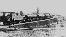
In 1890 the first sugar cane crushing mill in the Isis district was established at Doolbi. The mill produced juice, which was then taken to Yengarie for processing into sugar. In 1900, the Doolbi mill was upgraded to produce sugar. As more sugar mills opened in the district, there was not enough cane to keep them all profitable and the Doolbi mill closed in 1924. The mill was in the south-western corner of the present Isis Golf Course (25.231°S 152.300°E) and an old brick chimney is still visible.[4]
Horton State School opened circa 1888. In 1900, it was renamed Doolbi State School. It closed in 1953.[5] It was at 204 Goodwood Road (25.2279°S 152.3046°E),[6] now the site of the clubhouse of the Isis Golf Club.[7]
In the 2016 census, Doolbi had a population of 115 people.[1]
Education
There are no schools in Doolbi. The nearest primary and secondary schools are Childers State School and Isis District State High School, both in neighbouring Childers to the west.[3]
References
- Australian Bureau of Statistics (27 June 2017). "Doolbi (SSC)". 2016 Census QuickStats. Retrieved 20 October 2018.
- "Doolbi – locality in Bundaberg Region (entry 50193)". Queensland Place Names. Queensland Government. Retrieved 18 September 2020.
- "Queensland Globe". State of Queensland. Retrieved 20 October 2020.
- "Doolbi Sugar Mill Remains" (PDF). Bundaberg Regional Council. Archived (PDF) from the original on 17 November 2015. Retrieved 16 November 2015.
- Queensland Family History Society (2010), Queensland schools past and present (Version 1.01 ed.), Queensland Family History Society, ISBN 978-1-921171-26-0
- "Cordalba" (Map). Queensland Government. 1943. Retrieved 21 June 2022.
- "History of the club". Isis Golf Club. Archived from the original on 16 March 2022. Retrieved 21 June 2022.
External links
![]() Media related to Doolbi, Queensland at Wikimedia Commons
Media related to Doolbi, Queensland at Wikimedia Commons