Fairymead, Queensland
Fairymead is a coastal locality in the Bundaberg Region, Queensland, Australia.[2] In the 2021 census, Fairymead had a population of 28 people.[3]
| Fairymead Queensland | |||||||||||||||
|---|---|---|---|---|---|---|---|---|---|---|---|---|---|---|---|
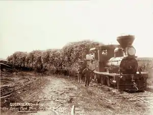
 Sugarcane train, Fairy Mead, circa 1896 | |||||||||||||||
 Fairymead | |||||||||||||||
| Coordinates | 24.7713°S 152.3533°E | ||||||||||||||
| Population | 28 (SAL 2021)[1] | ||||||||||||||
| Postcode(s) | 4670 | ||||||||||||||
| Area | 63.0 km2 (24.3 sq mi) | ||||||||||||||
| Time zone | AEST (UTC+10:00) | ||||||||||||||
| Location |
| ||||||||||||||
| LGA(s) | Bundaberg Region | ||||||||||||||
| State electorate(s) | Burnett | ||||||||||||||
| Federal division(s) | Flynn | ||||||||||||||
| |||||||||||||||
Geography
Fairymead is bounded to the north and north-east by the Coral Sea and to east and south-east by the Burnett River.[4]
Barubbra Island is an island at the mouth of the Burnett River (24.7488°S 152.3861°E).[5] It is a wetland area protected within the Barubbra Island Conservation Park.[5][4]
The predominant land use is growing sugarcane.[4] There is a cane tramway network through the locality to transport the harvested sugarcane to local sugar mills.[4]
History
Fairymead was originally established as the Fairymead Sugar Plantation with its associated Fairymead Sugar Mill (24.7898°S 152.3568°E).[6] The heritage-listed house built by the plantation owners, Fairymead House, has been relocated to the Bundaberg Botanic Gardens.[7]
Fairymead Provisional School opened on 20 July 1893. On 1 January 1909 it became Fairymead State School. It closed in 1983.[8] It was located at the eastern end of Colvins Road (approx 24.8094°S 152.3484°E).[9][10][4]
Demographics
In the 2016 census, Fairymead had a population of 33 people.[11]
In the 2021 census, Fairymead had a population of 28 people.[3]
Education
There are no schools in Fairymead. The nearest government primary schools are Moore Park Beach State School in neighbouring Moore Park Beach to the north-west, Gooburrum State School in neighbouring Gooburrum to the south-west, and Bundaberg North State School in Bundaberg North to the south. The nearest government secondary school is Bundaberg North State High School in Bundaberg North.[4]
See also
References
- Australian Bureau of Statistics (28 June 2022). "Fairymead (Suburb and Locality)". Australian Census 2021 QuickStats. Retrieved 28 June 2022.
- "Fairymead – locality in Bundaberg Region (entry 44717)". Queensland Place Names. Queensland Government. Retrieved 28 December 2017.
- Australian Bureau of Statistics (28 June 2022). "Fairymead (SAL)". 2021 Census QuickStats. Retrieved 28 February 2023.
- "Queensland Globe". State of Queensland. Retrieved 8 September 2023.
- "Barubbra Island – island in Bundaberg Regional (entry 1783)". Queensland Place Names. Queensland Government. Retrieved 29 August 2023.
- "9348-24 Bundaberg" (Map). Queensland Government. 2009. Archived from the original on 7 September 2023. Retrieved 8 September 2023.
- "Fairymead House (entry 601009)". Queensland Heritage Register. Queensland Heritage Council. Retrieved 1 August 2014.
- Queensland Family History Society (2010), Queensland schools past and present (Version 1.01 ed.), Queensland Family History Society, ISBN 978-1-921171-26-0
- "County of Cook" (Map). Queensland Government. 1920. Archived from the original on 21 February 2020. Retrieved 14 July 2021.
- "Bundaberg" (Map). Queensland Government. 1943. Archived from the original on 30 September 2020. Retrieved 14 July 2021.
- Australian Bureau of Statistics (27 June 2017). "Fairymead (SSC)". 2016 Census QuickStats. Retrieved 20 October 2018.
External links
![]() Media related to Fairymead, Queensland at Wikimedia Commons
Media related to Fairymead, Queensland at Wikimedia Commons
- "History of the House". Fairymead House. Archived from the original on 12 November 2018.