Jarkent
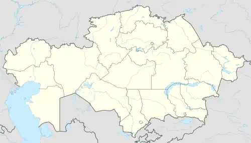
Jarkent (Kazakh: Жаркент, Jarkent), formerly known as Panfilov (Russian: Панфилов, until 1991) and Dzharkent (Russian: Джаркент, until 1942), is a city which serves as the administrative center of Panfilov District in the Almaty Region, Kazakhstan. It is located near the Usek river, not far from the Ili river. The city's population totaled 42,617 as of 2019.[1]
Jarkent
Жаркент | |
|---|---|
City | |
 | |
 Jarkent | |
| Coordinates: 44°10′N 80°0′E | |
| Country | Kazakhstan |
| Region | Jetisu Region |
| District | Panfilov District |
| Government | |
| • Akim | Sagymbek Marat Rahymberdievich |
| Population (2019) | |
| • Total | 42,617 |
| Time zone | UTC+6 (UTC + 6) |
| Postal codes | 041300-041305 |
| Area code | +7 72831 |
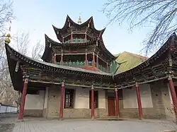
The town was founded in 1882 as Jarkent. From 1942 until 1991 it was named Panfilov after Ivan Panfilov, the Russian World War II hero who died in battle in 1941. Jarkent is well known for its nineteenth-century great mosque, commissioned by a wealthy merchant and community leader named Vali Bay. It is notable for its unique mix of Chinese and Central Asian styles of architecture.[2]
Climate
| Climate data for Jarkent (1991–2020, extremes 1917–present) | |||||||||||||
|---|---|---|---|---|---|---|---|---|---|---|---|---|---|
| Month | Jan | Feb | Mar | Apr | May | Jun | Jul | Aug | Sep | Oct | Nov | Dec | Year |
| Record high °C (°F) | 13.7 (56.7) |
20.0 (68.0) |
29.6 (85.3) |
35.5 (95.9) |
39.6 (103.3) |
40.9 (105.6) |
42.1 (107.8) |
41.4 (106.5) |
39.0 (102.2) |
32.3 (90.1) |
25.2 (77.4) |
16.6 (61.9) |
42.1 (107.8) |
| Average high °C (°F) | −0.8 (30.6) |
2.7 (36.9) |
12.0 (53.6) |
21.0 (69.8) |
26.2 (79.2) |
30.2 (86.4) |
32.1 (89.8) |
31.3 (88.3) |
26.6 (79.9) |
18.9 (66.0) |
9.1 (48.4) |
1.5 (34.7) |
17.6 (63.7) |
| Daily mean °C (°F) | −7.0 (19.4) |
−3.2 (26.2) |
5.7 (42.3) |
13.8 (56.8) |
18.9 (66.0) |
23.0 (73.4) |
24.7 (76.5) |
23.4 (74.1) |
18.3 (64.9) |
11.0 (51.8) |
2.7 (36.9) |
−4.2 (24.4) |
10.6 (51.1) |
| Average low °C (°F) | −11.7 (10.9) |
−7.9 (17.8) |
0.1 (32.2) |
7.0 (44.6) |
11.9 (53.4) |
16.2 (61.2) |
17.8 (64.0) |
16.0 (60.8) |
10.9 (51.6) |
4.7 (40.5) |
−1.9 (28.6) |
−8.4 (16.9) |
4.6 (40.3) |
| Record low °C (°F) | −40.6 (−41.1) |
−42.3 (−44.1) |
−28.0 (−18.4) |
−9.4 (15.1) |
−8.7 (16.3) |
2.1 (35.8) |
6.1 (43.0) |
4.9 (40.8) |
−5.0 (23.0) |
−12.3 (9.9) |
−36.5 (−33.7) |
−35.8 (−32.4) |
−42.3 (−44.1) |
| Average precipitation mm (inches) | 12 (0.5) |
14 (0.6) |
13 (0.5) |
22 (0.9) |
20 (0.8) |
24 (0.9) |
23 (0.9) |
16 (0.6) |
13 (0.5) |
16 (0.6) |
20 (0.8) |
13 (0.5) |
206 (8.1) |
| Mean monthly sunshine hours | 163 | 167 | 206 | 242 | 284 | 309 | 331 | 314 | 269 | 224 | 174 | 146 | 2,829 |
| Source 1: Pogoda.ru.net[3] | |||||||||||||
| Source 2: NOAA (sun, 1961–1990)[4] | |||||||||||||
Demographics
The city's population stood at 42,617 as of 2019;[1] 33,350 (2009 Census results);[5]and 32,656 (1999 Census results).[5]
References
![]() Media related to Zharkent at Wikimedia Commons
Media related to Zharkent at Wikimedia Commons
- 2019 жылдың басына Қазақстан Республикасы облыстары, қалалары, аудандары, аудан орталықтары және кенттері бөлінісіндегі халықтың жынысына қарай саны (in Kazakh and Russian). Комитет по статистике Министерства национальной экономики Республики Казахстан. 2019. Retrieved 2020-04-30.
- Brophy, David (2016). Uyghur Nation: Reform and Revolution on the Russia-China Frontier. Harvard University Press. p. 92. ISBN 978-0674660373.
- "Weather and Climate- The Climate of Jarkent" (in Russian). Weather and Climate (Погода и климат). Retrieved 5 January 2022.
- "Panfilov (Zharkent) Climate Normals 1961–1990". National Oceanic and Atmospheric Administration. Retrieved 5 January 2022.
- "Население Республики Казахстан" [Population of the Republic of Kazakhstan] (in Russian). Департамент социальной и демографической статистики. Retrieved 8 December 2013.
