List of extreme points of Belarus
This is a list of the extreme points of Belarus, the points that are farther north, south, east or west than any other location.
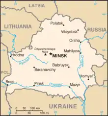
Map of Belarus
Latitude and longitude
- North: Verkhnyadzvinsk District, Vitebsk Region (56°10′N 28°07′E)
- South: Brahin District, Gomel Region (51°16′N 30°35′E)
- West: Kamenets District, Brest Region (52°17′N 23°11′E)
- East: Khotsimsk District, Mogilev Region (53°24′N 32°47′E)[1]
Altitude
- Maximum : Dzyarzhynskaya Hara, 345 m (53°51′N 27°04′E)
- Minimum : Nyoman River, 90 m
References
- "Coordinates of the extreme points of the state frontier. Main Geographic Characteristics of the Republic of Belarus". Land of Ancestors. 2011. Archived from the original on 21 September 2013. Retrieved 9 September 2013.
This article is issued from Wikipedia. The text is licensed under Creative Commons - Attribution - Sharealike. Additional terms may apply for the media files.