Galloway, New Zealand
Galloway is a rural locality in the Central Otago District of Otago in New Zealand. It is about 6.5 km northeast of Alexandra, on the eastern bank of the Manuherikia River, opposite Springvale.[1]
Galloway | |
|---|---|
Rural community | |
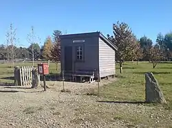 Remaining part of the Galloway station | |
| Coordinates: 45.211°S 169.461°E | |
| Country | New Zealand |
| Region | Otago |
| Territorial authority | Central Otago District |
| Ward | Vincent Ward |
| Government | |
| • Local authority | Central Otago District Council |
| • Regional council | Otago Regional Council |
| Time zone | UTC+12 (NZST) |
| • Summer (DST) | UTC+13 (NZDT) |
| Local iwi | Ngāi Tahu |
The Otago Central Rail Trail passes through Galloway.[2]
Demographics
Galloway is part of the Dunstan-Galloway statistical area, which covers 444.84 km2 (171.75 sq mi)[3] and had an estimated population of 2,090 as of June 2022,[4] with a population density of 4.7 people per km2.
| Year | Pop. | ±% p.a. |
|---|---|---|
| 2006 | 1,233 | — |
| 2013 | 1,329 | +1.08% |
| 2018 | 1,695 | +4.99% |
| Source: [5] | ||
Dunstan-Galloway had a population of 1,695 at the 2018 New Zealand census, an increase of 366 people (27.5%) since the 2013 census, and an increase of 462 people (37.5%) since the 2006 census. There were 612 households. There were 867 males and 831 females, giving a sex ratio of 1.04 males per female. The median age was 49.0 years (compared with 37.4 years nationally), with 291 people (17.2%) aged under 15 years, 204 (12.0%) aged 15 to 29, 897 (52.9%) aged 30 to 64, and 303 (17.9%) aged 65 or older.
Ethnicities were 94.5% European/Pākehā, 5.5% Māori, 1.6% Pacific peoples, 0.7% Asian, and 2.7% other ethnicities (totals add to more than 100% since people could identify with multiple ethnicities).
The proportion of people born overseas was 14.7%, compared with 27.1% nationally.
Although some people objected to giving their religion, 57.0% had no religion, 35.2% were Christian, 0.5% were Buddhist and 1.1% had other religions.
Of those at least 15 years old, 276 (19.7%) people had a bachelor or higher degree, and 243 (17.3%) people had no formal qualifications. The median income was $35,200, compared with $31,800 nationally. 285 people (20.3%) earned over $70,000 compared to 17.2% nationally. The employment status of those at least 15 was that 780 (55.6%) people were employed full-time, 288 (20.5%) were part-time, and 18 (1.3%) were unemployed.[5]
Education
A school flourished in Galloway in 1894[6][7] although it closed in 1896 due to concerns over scarlet fever.[8]
A new school was built in 1912[9][10] and closed in 1941, with the building becoming a community hall.[11]
References
- Harriss, Gavin (July 2021). Galloway, Otago (Map). NZ Topo Map.
- "Alexandra - Chatto Creek". Otago Rail Trail. Retrieved 6 December 2021.
- "ArcGIS Web Application". statsnz.maps.arcgis.com. Retrieved 6 December 2021.
- "Population estimate tables - NZ.Stat". Statistics New Zealand. Retrieved 25 October 2022.
- "Statistical area 1 dataset for 2018 Census". Statistics New Zealand. March 2020. Dunstan-Galloway (345300). 2018 Census place summary: Dunstan-Galloway
- "Our Dunedin Letter". Dunstan Times. 1 June 1894.
- "Clyde". Otago Witness. 28 June 1894.
- "Dunstan District New Items". Cromwell Argus. 27 October 1896.
- "Local & General". Dunstan Times. 25 March 1912.
- "Opening of Galloway School". Alexandra Herald and Central Otago Gazette. 17 July 1912.
- van Kempen, Lynda (21 September 2011). "District and school share an occasion". Otago Daily Times.