Glennville, Georgia
Glennville is a small city in southeastern Tattnall County, Georgia, United States. As of the 2020 census, the town had a population of 3,834.
Glennville, Georgia | |
|---|---|
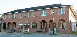 Glennwanis Hotel, East Barnard Street Downtown Glennville, GA | |
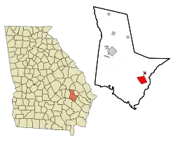 Location in Tattnall County and the state of Georgia | |
| Coordinates: 31.937°N 81.929°W[1] | |
| Country | United States |
| State | Georgia |
| County | Tattnall |
| Government | |
| • Mayor | Bernie Weaver |
| Area | |
| • Total | 7.13 sq mi (18.47 km2) |
| • Land | 7.05 sq mi (18.26 km2) |
| • Water | 0.08 sq mi (0.21 km2) |
| Elevation | 171 ft (52 m) |
| Population (2020) | |
| • Total | 3,834 |
| • Density | 543.91/sq mi (210.01/km2) |
| Time zone | UTC-5 (Eastern (EST)) |
| • Summer (DST) | UTC-4 (EDT) |
| ZIP code | 30427 |
| Area code | 912 |
| FIPS code | 13-33336[3] |
| GNIS feature ID | 0331820[4] |
| Website | www |
Geography
Glennville lies within the coastal plain of Georgia, surrounded by farmland and forest. The Altamaha River is 10 miles (16 km) to the southwest. Less than 2 miles to the east of Glennville, Beards Creek forms the border with Long County; just east of the creek is the edge of Fort Stewart. The nearest major city is Savannah, approximately 50 miles (80 km) east of Glennville. Baxley, Georgia, is 29 miles (47 km) southwest of Glennville.
According to the United States Census Bureau, as of 2020 the city had a total area of 7.13 square miles (18.5 km2), of which 7.05 square miles (18.3 km2) was land and 0.08 square miles (0.21 km2) was water.
Major highways
There are multiple partial concurrencies among route numbers; descriptions are omitted here for simplicity:
Climate
| Climate data for Glennville, Georgia (1991–2020 normals, extremes 1946–present) | |||||||||||||
|---|---|---|---|---|---|---|---|---|---|---|---|---|---|
| Month | Jan | Feb | Mar | Apr | May | Jun | Jul | Aug | Sep | Oct | Nov | Dec | Year |
| Record high °F (°C) | 84 (29) |
87 (31) |
94 (34) |
97 (36) |
103 (39) |
110 (43) |
113 (45) |
105 (41) |
106 (41) |
98 (37) |
89 (32) |
85 (29) |
113 (45) |
| Mean maximum °F (°C) | 77.0 (25.0) |
79.9 (26.6) |
85.0 (29.4) |
89.3 (31.8) |
94.5 (34.7) |
98.5 (36.9) |
100.0 (37.8) |
98.4 (36.9) |
95.3 (35.2) |
89.0 (31.7) |
83.8 (28.8) |
78.2 (25.7) |
100.9 (38.3) |
| Average high °F (°C) | 60.6 (15.9) |
64.7 (18.2) |
71.3 (21.8) |
78.6 (25.9) |
85.2 (29.6) |
90.1 (32.3) |
92.3 (33.5) |
91.2 (32.9) |
86.6 (30.3) |
78.9 (26.1) |
69.9 (21.1) |
62.8 (17.1) |
77.7 (25.4) |
| Daily mean °F (°C) | 49.0 (9.4) |
52.5 (11.4) |
58.7 (14.8) |
65.5 (18.6) |
72.9 (22.7) |
79.3 (26.3) |
81.9 (27.7) |
81.1 (27.3) |
76.4 (24.7) |
67.1 (19.5) |
57.8 (14.3) |
51.4 (10.8) |
66.1 (18.9) |
| Average low °F (°C) | 37.5 (3.1) |
40.4 (4.7) |
46.0 (7.8) |
52.4 (11.3) |
60.7 (15.9) |
68.5 (20.3) |
71.5 (21.9) |
71.0 (21.7) |
66.2 (19.0) |
55.2 (12.9) |
45.6 (7.6) |
40.1 (4.5) |
54.6 (12.6) |
| Mean minimum °F (°C) | 22.7 (−5.2) |
25.7 (−3.5) |
30.5 (−0.8) |
38.7 (3.7) |
49.2 (9.6) |
61.9 (16.6) |
67.1 (19.5) |
65.6 (18.7) |
54.9 (12.7) |
41.0 (5.0) |
30.9 (−0.6) |
25.5 (−3.6) |
20.1 (−6.6) |
| Record low °F (°C) | 1 (−17) |
11 (−12) |
17 (−8) |
28 (−2) |
40 (4) |
52 (11) |
59 (15) |
52 (11) |
40 (4) |
28 (−2) |
13 (−11) |
9 (−13) |
1 (−17) |
| Average precipitation inches (mm) | 3.83 (97) |
3.78 (96) |
3.86 (98) |
3.01 (76) |
3.50 (89) |
5.96 (151) |
5.32 (135) |
7.48 (190) |
3.33 (85) |
3.59 (91) |
2.55 (65) |
3.56 (90) |
49.77 (1,264) |
| Average precipitation days | 8.4 | 7.7 | 6.5 | 6.4 | 6.4 | 9.5 | 9.8 | 10.9 | 7.1 | 5.7 | 5.6 | 7.2 | 91.2 |
| Source: NOAA[5][6] | |||||||||||||
Demographics
| Census | Pop. | Note | %± |
|---|---|---|---|
| 1900 | 269 | — | |
| 1910 | 640 | 137.9% | |
| 1920 | 1,069 | 67.0% | |
| 1930 | 1,503 | 40.6% | |
| 1940 | 1,674 | 11.4% | |
| 1950 | 2,327 | 39.0% | |
| 1960 | 2,791 | 19.9% | |
| 1970 | 2,965 | 6.2% | |
| 1980 | 4,144 | 39.8% | |
| 1990 | 3,676 | −11.3% | |
| 2000 | 3,641 | −1.0% | |
| 2010 | 3,569 | −2.0% | |
| 2020 | 3,834 | 7.4% | |
| U.S. Decennial Census[7] | |||
2020 census
| Race | Num. | Perc. |
|---|---|---|
| White (non-Hispanic) | 2,037 | 53.13% |
| Black or African American (non-Hispanic) | 1,318 | 34.38% |
| Native American | 8 | 0.21% |
| Asian | 57 | 1.49% |
| Pacific Islander | 3 | 0.08% |
| Other/Mixed | 127 | 3.31% |
| Hispanic or Latino | 284 | 7.41% |
As of the 2020 United States census, there were 3,834 people residing in the city; these included 1,477 households and 1,071 families.
2000 census
As of the census[3] of 2000, there were 3,641 people in the city, including 1,428 households and 912 families. The population density was 553.4 inhabitants per square mile (213.7/km2). There were 1,668 housing units, at an average density of 253.5 per square mile (97.9/km2). The racial makeup of the city was 63.36% White, 33.64% African American, 0.14% Native American, 0.71% Asian, 0.11% Pacific Islander, 1.29% from other races, and 0.74% from two or more races. Hispanic or Latino of any race were 2.42% of the population.
Of the 1,428 households, 29.8% had children under the age of 18 living with them, 44.2% were married couples living together, 16.1% had a female householder with no husband present, and 36.1% were non-families. 32.2% of all households were made up of individuals, and 16.5% had someone living alone who was 65 years of age or older. The average (mean) household size was 2.42 and the average family size was 3.07.
The median age was 38 years, with 26.5% of the population under the age of 18, 8.3% from 18 to 24, 24.6% from 25 to 44, 20.8% from 45 to 64, and 19.8% who were 65 years of age or older. For every 100 females, there were 78.6 males. For every 100 females age 18 and over, there were 72.0 males.
The median household income was $24,309, and the median family income was $35,066. Males had a median income of $26,861, versus $16,982 for females. The per capita income for the city was $13,427. About 21.7% of families and 28.7% of the population were below the poverty line, including 46.0% of those under age 18 and 17.2% of those age 65 or over.
Economy
The Georgia Department of Corrections provides jobs for hundreds of people within Tattnall County and surrounding counties. Smith State Prison, a close-security facility, is located 2 miles north of Glennville. The facility can house 1000+ inmates at any given time.
The city is known for farming crickets to use as animal feed, as well as for pecans.[9]
Notable people
- Osjha Anderson, Miss Georgia 1999
- Laura Belle Barnard, missionary, humanitarian, and educator; author of The Biblical Basis of Missions
- Beach Dickerson, Hollywood actor & producer who worked frequently with director Roger Corman
- Jesse Finch, US roster for baseball at 1956 Olympics in Melbourne, Australia
- Mason G. Rhodes, former athlete at Paine College; Rio Olympian and Paralympian in track and field, 2016
- Shannon Sharpe, co-host of ESPN First Take, former co-host of FS1 Undisputed, former football analyst for CBS, former collegiate and professional football player with Savannah State University and the Denver Broncos, Pro Football Hall of Fame Inductee 2011, brother of Sterling Sharpe
- Sterling Sharpe, former collegiate and professional football player with the University of South Carolina and the Green Bay Packers. 2014 College Football Hall of Fame Inductee, brother of Shannon Sharpe
- Cole Swindell, American country music singer–songwriter
- Drew Tarver, actor and comedian; brother of Katelyn Tarver
- Katelyn Tarver, singer, actress, and model; sister of Drew Tarver
Media
The Journal Sentinel of Tattnall County, with offices in the county seat of Reidsville as well as in Glennville, has been published since 1879.[10]
In popular culture
Glennville is the principal setting of Eternal Fire, a novel by Georgia-born author Calder Willingham.
Historic structures
- Beards Creek Primitive Baptist Church, 5 miles northeast of town, was established in 1804.
- The Glennwanis Hotel, located in downtown Glennville, was built in 1926. It was added to the National Register of Historic Places in 2003.
References
- "US Gazetteer files: 2010, 2000, and 1990". United States Census Bureau. February 12, 2011. Retrieved April 23, 2011.
- "2020 U.S. Gazetteer Files". United States Census Bureau. Retrieved December 18, 2021.
- "U.S. Census website". United States Census Bureau. Retrieved January 31, 2008.
- "US Board on Geographic Names". United States Geological Survey. October 25, 2007. Retrieved January 31, 2008.
- "NOWData – NOAA Online Weather Data". National Oceanic and Atmospheric Administration. Retrieved April 23, 2023.
- "Summary of Monthly Normals 1991–2020". National Oceanic and Atmospheric Administration. Retrieved April 23, 2023.
- "Census of Population and Housing". Census.gov. Retrieved June 4, 2015.
- "Explore Census Data". data.census.gov. Retrieved December 18, 2021.
- "Glennville", Explore Georgia. Retrieved 2014-5-20.
- The Journal Sentinel, Tattnall County, archives. Retrieved August 6, 2023.
External links
- Official website, City of Glennville
- Official website, Tattnall County
Municipalities and communities of Tattnall County, Georgia, United States | ||
|---|---|---|
| Cities |  Map of Georgia highlighting Tattnall County | |
| CDP | ||
| Unincorporated community | ||
| Ghost town | ||