Gonabad County
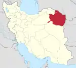
Gonabad County (Persian: شهرستان گناباد) is in Razavi Khorasan province, Iran. Its capital is the city of Gonabad.
Gonabad County
Persian: شهرستان گناباد | |
|---|---|
County | |
 Castle of Yazdegerd III | |
.svg.png.webp) Location of Gonabad County in Razavi Khorasan province | |
 Location of Razavi Khorasan province in Iran | |
| Coordinates: 34°26′N 58°52′E[1] | |
| Country | Iran |
| Province | Razavi Khorasan |
| Capital | Gonabad |
| Districts | Central, Kakhk |
| Area | |
| • Total | 5,789 km2 (2,235 sq mi) |
| Elevation | 1,105 m (3,625 ft) |
| Population (2016)[2] | |
| • Total | 88,753 |
| • Density | 15/km2 (40/sq mi) |
| Time zone | UTC+3:30 (IRST) |
At the 2006 census, the county's population was 106,158, in 30,357 households.[3] The following census in 2011 counted 80,783 people in 24,292 households, by which time Bajestan District had been separated from the county to form Bajestan County.[4] At the 2016 census, Gonabad County's population was 88,753 in 27,607 households.[2]
Climate and geography
Gonabad is located in a plate area on the north of the Brakoh mountain or Kūh-e Tīr Māhī [5]
Administrative divisions
The population history and structural changes of Gonabad County's administrative divisions over three consecutive censuses are shown in the following table. The latest census shows two districts, four rural districts, and three cities.[2]
| Administrative Divisions | 2006[3] | 2011[4] | 2016[2] |
|---|---|---|---|
| Central District | 64,849 | 69,773 | 76,427 |
| Howmeh Rural District | 16,701 | 18,727 | 20,989 |
| Pas Kalut Rural District | 8,762 | 9,331 | 9,164 |
| Bidokht (city) | 4,823 | 5,348 | 5,501 |
| Gonabad (city) | 34,563 | 36,367 | 40,773 |
| Bajestan District1 | 29,495 | ||
| Bajestan Rural District | 3,382 | ||
| Jazin Rural District | 5,294 | ||
| Yunesi Rural District | 6,334 | ||
| Bajestan (city) | 11,136 | ||
| Yunesi (city) | 3,349 | ||
| Kakhk District | 11,814 | 11,010 | 12,326 |
| Kakhk Rural District | 3,052 | 2,354 | 2,809 |
| Zibad Rural District | 4,747 | 4,243 | 4,892 |
| Kakhk (city) | 4,015 | 4,413 | 4,625 |
| Total | 106,158 | 80,783 | 88,753 |
| 1Became a part of Bajestan County | |||
Historical places
See also
References
- OpenStreetMap contributors (29 April 2023). "Gonabad County" (Map). OpenStreetMap. Retrieved 29 April 2023.
- "Census of the Islamic Republic of Iran, 1395 (2016)". AMAR (in Persian). The Statistical Center of Iran. p. 09. Archived from the original (Excel) on 2 April 2022. Retrieved 19 December 2022.
- "Census of the Islamic Republic of Iran, 1385 (2006)". AMAR (in Persian). The Statistical Center of Iran. p. 09. Archived from the original (Excel) on 20 September 2011. Retrieved 25 September 2022.
- "Census of the Islamic Republic of Iran, 1390 (2011)" (Excel). Iran Data Portal (in Persian). The Statistical Center of Iran. p. 09. Retrieved 19 December 2022.
- Ajam, Mohammad. Geography and tribes and minorities in Khorasan, research published 1992, University of Imam Sadegh, Tehran
Gallery
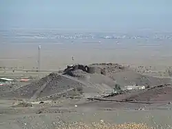
 Zibad Castle
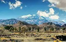 Zibad Mountain
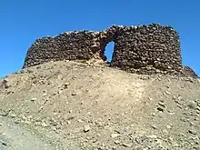 Sassanian Castel
 Ancient water clock used in a qanat of Gonabad 2500 years ago
| Capital | |||||||||||||||||||||
|---|---|---|---|---|---|---|---|---|---|---|---|---|---|---|---|---|---|---|---|---|---|
| Districts |
| ||||||||||||||||||||