Grafton (CDP), Vermont
Grafton is the central village and a census-designated place (CDP) in the town of Grafton, Windham County, Vermont, United States. As of the 2020 census, it had a population of 49,[2] compared to 645 in the entire town.
Grafton, Vermont | |
|---|---|
 Grafton  Grafton | |
| Coordinates: 43°10′21″N 72°36′31″W | |
| Country | United States |
| State | Vermont |
| County | Windham |
| Town | Grafton |
| Area | |
| • Total | 0.13 sq mi (0.34 km2) |
| • Land | 0.13 sq mi (0.34 km2) |
| • Water | 0.0 sq mi (0.0 km2) |
| Elevation | 856 ft (261 m) |
| Population | 49 |
| Time zone | UTC-5 (Eastern (EST)) |
| • Summer (DST) | UTC-4 (EDT) |
| ZIP Code | 05146 |
| Area code | 802 |
| FIPS code | 50-28825 |
| GNIS feature ID | 2807160[3] |
The CDP is in northern Windham County, southeast of the center of Grafton. It sits in the valley of the Saxtons River, where it is joined by its South Branch. The Saxtons is an east-flowing tributary of the Connecticut River.
Vermont Route 121 serves as Grafton's Main Street. It leads southeast 11 miles (18 km) to Bellows Falls on the Connecticut River and northwest 14 miles (23 km) to Londonderry. Vermont Route 35 (Chester Hill Road) runs north out of Grafton, leading 7 miles (11 km) to Chester. Route 35 joins Route 121 east out of Grafton but later turns south and leads a total of 14 miles (23 km) to Townshend.
References
- "2020 U.S. Gazetteer Files – Vermont". United States Census Bureau. Retrieved October 21, 2021.
- "Grafton CDP, Vermont: 2020 DEC Redistricting Data (PL 94-171)". U.S. Census Bureau. Retrieved October 21, 2021.
- "Grafton Census Designated Place". Geographic Names Information System. United States Geological Survey, United States Department of the Interior.
Municipalities and communities of Windham County, Vermont, United States | ||
|---|---|---|
| Towns | 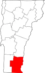 Map of Vermont highlighting Windham County | |
| Villages | ||
| CDPs | ||
| Other communities | ||
| Footnotes | § Disincorporated ‡ This populated place also has portions in an adjacent county or counties | |