Gya, Ladakh
Gya (Wylie: rGya)[2] or Gia is a village in the Leh district of Ladakh in India.[3] It is located in the Kharu tehsil, off the Leh–Manali Highway, close to Tso Kar.
Gya
rGya Gia | |
|---|---|
Village | |
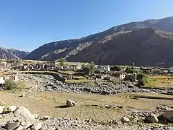 Gya Village | |
 Gya Location in Ladakh  Gya Gya (India) | |
| Coordinates: 33.280068°N 77.938785°E | |
| Country | India |
| Union Territory | Ladakh |
| District | Leh |
| Tehsil | Kharu[1] |
| Population (2011) | |
| • Total | 658 |
| Languages | |
| • Official | Hindi, English |
| Time zone | UTC+5:30 (IST) |
| Census code | 894 |
The village overlooks the Gya river in the Ladakh region, between the Indus river valley and Tanglang La Pass on the Leh-Manali Highway. Accessible from Upshi in the Indus River Valley, the village is located in the gorge created by the River Gya. A Buddhist Gompa with accompanying chortens or stupas is situated above the village and the gorge.
Most of the people are engaged in agriculture adopting organic farming. The village is still protected with its old heritage and culture for which countless tourist love to visit there.
Demographics
According to the 2011 census of India, Gya has 140 households. The effective literacy rate (i.e. the literacy rate of population excluding children aged 6 and below) is 58.67%.[4]
| Total | Male | Female | |
|---|---|---|---|
| Population | 658 | 301 | 357 |
| Children aged below 6 years | 87 | 39 | 48 |
| Scheduled caste | 0 | 0 | 0 |
| Scheduled tribe | 657 | 301 | 356 |
| Literates | 335 | 172 | 163 |
| Workers (all) | 365 | 177 | 188 |
| Main workers (total) | 103 | 80 | 23 |
| Main workers: Cultivators | 58 | 50 | 8 |
| Main workers: Agricultural labourers | 0 | 0 | 0 |
| Main workers: Household industry workers | 0 | 0 | 0 |
| Main workers: Other | 45 | 30 | 15 |
| Marginal workers (total) | 262 | 97 | 165 |
| Marginal workers: Cultivators | 196 | 64 | 132 |
| Marginal workers: Agricultural labourers | 0 | 0 | 0 |
| Marginal workers: Household industry workers | 0 | 0 | 0 |
| Marginal workers: Others | 66 | 33 | 33 |
| Non-workers | 293 | 124 | 169 |
References
- "Villages | District Leh, Union Territory of Ladakh | India".
- Erberto Lo Bue; John Bray, eds. (2014), Art and Architecture in Ladakh: Cross-cultural Transmissions in the Himalayas and Karakoram, BRILL, ISBN 978-90-04-27180-7
- "Blockwise Village Amenity Directory" (PDF). Ladakh Autonomous Hill Development Council. Retrieved 23 July 2015.
- "Leh district census". 2011 Census of India. Directorate of Census Operations. Retrieved 23 July 2015.
| State symbols | |||||||||||||||||||
|---|---|---|---|---|---|---|---|---|---|---|---|---|---|---|---|---|---|---|---|
| History |
| ||||||||||||||||||
| Administration | |||||||||||||||||||
| Geography |
| ||||||||||||||||||
| Human settlements | |||||||||||||||||||
| Culture |
| ||||||||||||||||||
| Tourism and wildlife |
| ||||||||||||||||||
| Transport |
| ||||||||||||||||||
| Infrastructure |
| ||||||||||||||||||
| See also |
| ||||||||||||||||||