Shangri-La City
Shangri-La (Chinese: 香格里拉; pinyin: Xiānggélǐlā, Tibetan: སེམས་ཀྱི་ཉི་ཟླ།) is a county-level city in Northwestern Yunnan Province, China and is the location of the seat of the Dêqên Tibetan Autonomous Prefecture, bordering Sichuan to the northwest, north, and east.
Shangri-La
香格里拉市 · སེམས་ཀྱི་ཉི་ཟླ་གྲོང་ཁྱེར། | |
|---|---|
.jpg.webp) | |
.png.webp) Location of Shangri-La County (pink) and Dêqên Tibetan Autonomous Prefecture (yellow) within Yunnan | |
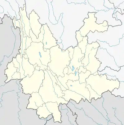 Shangri-La Location of the county seat in Yunnan | |
| Coordinates (Dêqên Prefecture government): 27°50′45″N 99°44′32″E | |
| Country | China |
| Province | Yunnan |
| Autonomous prefecture | Dêqên |
| Municipal seat | Gyalthang Town |
| Area | |
| • Total | 11,613 km2 (4,484 sq mi) |
| Elevation | 3,160 m (10,370 ft) |
| Population (2020 census)[2] | |
| • Total | 186,412 |
| • Density | 16/km2 (42/sq mi) |
| Time zone | UTC+8 (China Standard) |
| Postal code | 674400 |
| Area code | 0887 |
| Website | xianggelila |
| Shangri-La City | |||||||||||
|---|---|---|---|---|---|---|---|---|---|---|---|
| Chinese name | |||||||||||
| Chinese | 香格里拉 | ||||||||||
| |||||||||||
| Alternative Chinese name | |||||||||||
| Chinese | 中甸 | ||||||||||
| |||||||||||
| Tibetan name | |||||||||||
| Tibetan | སེམས་ཀྱི་ཉི་ཟླ། | ||||||||||
| |||||||||||
Name
Shangri-La was formerly called Zhongdian County in Chinese (中甸县; Zhōngdiàn Xiàn) and Gyalthang (Tibetan: རྒྱལ་ཐང་, Wylie: rgyal thang, ZYPY: Gyaitang) in Tibetan, renamed on 17 December 2001 and upgraded into a county-level city on 16 December 2014 as Shangri-La (other spellings: Semkyi'nyida, Xianggelila, or Xamgyi'nyilha), after the fictional land of Shangri-La in the 1933 James Hilton novel Lost Horizon, in an effort to promote tourism in the area. Formerly, the Tibetan population referred to the city by its traditional name Gyalthang or Gyaitang, meaning "Royal plains". The Chinese name of the county seat, Jiantang (建塘; Jiàntáng), reflects the pronunciation of Gyalthang.
In the early morning of January 11, 2014, a fire broke out in the 1,000-year-old Dukezong Tibetan neighborhood. About 242 homes and shops were destroyed and 2,600 residents were displaced.[3] About half of the old town was destroyed by the fire, while the other half was spared. After the fire, residents were allowed back to their homes and shops. By the end of 2014 rebuilding had started and tourism started to return. Tourism was generally not affected by the fire, since the main sights in the old town, such as the prayer wheel and temples, were not damaged. Many of the other main sights are located outside of the old town.
Demographics and languages
.jpg.webp)
The southern half of the city is inhabited by the Naxi people, who speak the Naxi language, a Lolo-Burmese language separate from the Tibetic languages. The northern half is inhabited by the Khampas, who speak the southern variety of Khams Tibetan. Southwestern Mandarin is spoken by the Han Chinese throughout the city.
Administrative divisions
Shangri-La City has 4 towns, 6 townships and 1 ethnic township.[4]
| Name | Simplified Chinese | Hanyu Pinyin | Tibetan | Wylie | Administrative division code | |
|---|---|---|---|---|---|---|
| Towns | ||||||
| Gyalthang Town (Jiantang) |
建塘镇 | Jiàntáng zhèn | རྒྱལ་ཐང་གྲོང་རྡལ། | rgyal thang grong rdal | 533401101 | |
| Yangthang Town (Xiaozhongdian) |
小中甸镇 | Xiǎozhōngdiàn zhèn | ཡང་ཐང་གྲོང་རྡལ། | yang thang grong rdal | 533401102 | |
| Hutiaoxia Town | 虎跳峡镇 | Hǔtiàoxiá zhèn | 533401103 | |||
| Jinjiang Town | 金江镇 | Jīnjiāng zhèn | 533401104 | |||
| Townships | ||||||
| Shangjiang Township | 上江乡 | Shàngjiāng xiāng | 533401201 | |||
| Luoji Township | 洛吉乡 | Luòjí xiāng | 533401203 | |||
| Nyishar Township (Nixi) |
尼西乡 | Níxī xiāng | ནོར་སྐྱིད་ཞང་། | nyi shar zhang | 533401204 | |
| Ketsak Township (Gezan) |
格咱乡 | Gézán xiāng | སྐད་ཚག་ཤང་། | skad tshag shang | 533401205 | |
| Dorwarong Township (Torwarong, Dongwang) |
东旺乡 | Dōngwàng xiāng | གཏོར་བ་རོང་ཤང་། | gtor ba rong shang | 533401206 | |
| Rongpagyurnga Township (Wujing) |
五境乡 | Wǔjìng xiāng | རོང་པ་སྒྱུར་ལྔ་ཤང་། | rong pa sgyur lnga shang | 533401207 | |
| Ethnic township | ||||||
| Sanba Naxi Ethnic Township | 三坝纳西族乡 | Sānbà Nàxīzú xiāng | 533401202 | |||
Climate
Shangri-La has either a dry-winter, warm-summer humid continental climate (Köppen climate classification: Dwb), or a dry-winter subtropical highland climate (Köppen climate classification: Cwb), both of which are unusually cool by Yunnan standards due to the high elevation, which ranges between 2,700 and 3,500 metres (8,900 and 11,500 ft). Winters are chilly but sunny, with a January 24-hour average temperature of −2.3 °C (27.9 °F), while summers are cool, with a July 24-hour average temperature of 13.9 °C (57.0 °F), and feature frequent rain; more than 70% of the annual precipitation is delivered from June to September. The annual mean is 6.32 °C (43.4 °F). Except during the summer, nights are usually sharply cooler than the days. Despite the dryness of the winter, the small amount of precipitation is generally sufficient to cause major transportation dislocations and isolate the area between November and March.
| Climate data for Shangri-La (1991–2020 normals, extremes 1971–2010) | |||||||||||||
|---|---|---|---|---|---|---|---|---|---|---|---|---|---|
| Month | Jan | Feb | Mar | Apr | May | Jun | Jul | Aug | Sep | Oct | Nov | Dec | Year |
| Record high °C (°F) | 20.4 (68.7) |
18.2 (64.8) |
21.5 (70.7) |
22.7 (72.9) |
24.2 (75.6) |
26.0 (78.8) |
26.0 (78.8) |
25.5 (77.9) |
23.8 (74.8) |
20.9 (69.6) |
18.8 (65.8) |
17.9 (64.2) |
26.0 (78.8) |
| Average high °C (°F) | 6.9 (44.4) |
7.8 (46.0) |
9.9 (49.8) |
13.0 (55.4) |
16.8 (62.2) |
19.7 (67.5) |
19.4 (66.9) |
19.2 (66.6) |
17.9 (64.2) |
14.9 (58.8) |
11.6 (52.9) |
8.9 (48.0) |
13.8 (56.9) |
| Daily mean °C (°F) | −2.0 (28.4) |
0.1 (32.2) |
3.0 (37.4) |
6.1 (43.0) |
10.1 (50.2) |
13.8 (56.8) |
14.0 (57.2) |
13.5 (56.3) |
12.1 (53.8) |
7.6 (45.7) |
2.4 (36.3) |
−1.1 (30.0) |
6.6 (43.9) |
| Average low °C (°F) | −9.2 (15.4) |
−6.1 (21.0) |
−2.4 (27.7) |
0.6 (33.1) |
4.6 (40.3) |
9.4 (48.9) |
10.6 (51.1) |
10.1 (50.2) |
8.5 (47.3) |
2.3 (36.1) |
−4.6 (23.7) |
−8.9 (16.0) |
1.2 (34.2) |
| Record low °C (°F) | −23.9 (−11.0) |
−20.5 (−4.9) |
−17.5 (0.5) |
−10 (14) |
−7.4 (18.7) |
−2.1 (28.2) |
1.1 (34.0) |
1.0 (33.8) |
−3.0 (26.6) |
−11.1 (12.0) |
−16.5 (2.3) |
−27.4 (−17.3) |
−27.4 (−17.3) |
| Average precipitation mm (inches) | 12.2 (0.48) |
14.6 (0.57) |
30.6 (1.20) |
26.9 (1.06) |
44.5 (1.75) |
72.0 (2.83) |
159.9 (6.30) |
155.5 (6.12) |
80.1 (3.15) |
32.8 (1.29) |
8.7 (0.34) |
3.5 (0.14) |
641.3 (25.23) |
| Average precipitation days (≥ 0.1 mm) | 5.4 | 5.9 | 9.8 | 10.0 | 11.9 | 15.5 | 22.3 | 23.0 | 17.8 | 9.7 | 2.7 | 1.7 | 135.7 |
| Average snowy days | 9.4 | 11.4 | 13.2 | 4.1 | 0.3 | 0 | 0 | 0 | 0.2 | 0.6 | 4.0 | 4.8 | 48 |
| Average relative humidity (%) | 57 | 59 | 62 | 64 | 66 | 70 | 78 | 79 | 77 | 70 | 61 | 55 | 67 |
| Mean monthly sunshine hours | 239.3 | 208.6 | 202.1 | 184.7 | 189.9 | 150.3 | 108.1 | 120.3 | 127.7 | 189.7 | 228.3 | 253.7 | 2,202.7 |
| Percent possible sunshine | 73 | 65 | 54 | 48 | 45 | 36 | 26 | 30 | 35 | 54 | 71 | 79 | 51 |
| Source 1: China Meteorological Administration[5][6] | |||||||||||||
| Source 2: Weather China[7] | |||||||||||||
National park
.jpg.webp)
- Pudacuo National Park, the first national park in China to meet IUCN standards, is part of the Three Parallel Rivers of Yunnan Protected Areas World Heritage Site.
Transport
- The city's airport is Diqing Shangri-La Airport. Covering an area of 225 hectares, it is one of the biggest airports in the northwest of Yunnan. There are flights to Kunming, Chengdu, Lhasa, Guangzhou and Shenzhen.
- Since there is no railway available in Shangri-la, taking a long-distance bus is also a major means to get to Shangri-la besides flight. It takes about four hours to get to Shangri-la from Lijiang by bus. Tourists who rent a car for the trip can also visit the Tiger Leaping Gorge and the First Bend of Yangtze River on the way.[8] The Lijiang–Shangri-La railway is under construction and estimated to be completed in 2020.
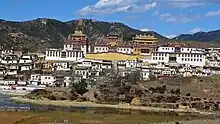
- Many travelers use the county town as a gateway into Tibet, either travelling many days overland by jeep to Lhasa, or by flying from the city's airport. However, the town itself is a tourist destination, primarily due to the nearby Gandan Sumtseling Monastery, Ganden Sumtsen Ling, 松赞林寺 Sōngzànlín Sì), Pudacuo National Park, and Tiger Leaping Gorge.
- China National Highway 214
See also
- Shangri-La
- Shangri-La Beer
- Three Parallel Rivers of Yunnan Protected Areas - UNESCO World Heritage Site
References
- "Shangri-La (Xiānggélǐlā 香格里拉), chef-lieu de la préfecture autonome tibétaine de Diqing, Yunnan (Yúnnán 云南)". channaryetfrancoisashanghai.net (in French). Retrieved 10 August 2015.
- "迪庆州第七次全国人口普查主要数据公报" (in Chinese). Government of Dêqên Prefecture. 2021-05-27.
- "Night fire burns for hours, destroys ancient Tibetan town in southwest China's Shangri-La county". Toledo Blade. January 11, 2014.
- "国家统计局" (in Chinese). National Bureau of Statistics of the People's Republic of China. Retrieved 2021-12-07.
- 1981-2010 extremes 中国气象数据网 – WeatherBk Data (in Simplified Chinese). China Meteorological Administration. Retrieved 9 April 2023.
- 1991-2020 normals "Climate averages from 1991 to 2020". China Meteorological Administration. 2023-04-24. Archived from the original on 2023-04-17.
- 1971-2000 extremes 香格里拉 - 气象数据 -中国天气网 (in Chinese). Weather China. Archived from the original on 2023-04-05. Retrieved 21 November 2022.
- "Shangri-la Transportation" ChinaTour.net Accessed 2014-5-9
Further reading
- Forbes, Andrew ; Henley, David (2011). China's Ancient Tea Horse Road. Chiang Mai: Cognoscenti Books. ASIN: B005DQV7Q2
- Holas, Ashild. "Tourism and Tibetan Culture in Transition: A Place Called Shangrila" (Routledge Contemporary China Series). Routledge, September 12, 2007. ISBN 8173871094, 9788173871092.