Hillsborough (CDP), New Jersey
Hillsborough is a census-designated place (CDP)[5] located in the center of Hillsborough Township, Somerset County, in the U.S. state of New Jersey. It was first listed as a CDP prior to the 2020 census.[4]
Hillsborough, New Jersey | |
|---|---|
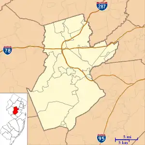 Hillsborough CDP Location in Somerset County  Hillsborough CDP Location in New Jersey  Hillsborough CDP Location in the United States | |
| Coordinates: 40°30′23″N 74°39′9″W | |
| Country | |
| State | |
| County | Somerset |
| Township | Hillsborough |
| Area | |
| • Total | 8.02 sq mi (20.77 km2) |
| • Land | 8.00 sq mi (20.72 km2) |
| • Water | 0.02 sq mi (0.05 km2) |
| Elevation | 110 ft (30 m) |
| Population | |
| • Total | 22,214 |
| • Density | 2,776.1/sq mi (1,071.9/km2) |
| Time zone | UTC−05:00 (Eastern (EST)) |
| • Summer (DST) | UTC−04:00 (EDT) |
| ZIP Code | 08844 |
| Area code | 908 |
| FIPS code | 34-31880[3] |
| GNIS feature ID | 2806101[4] |
The CDP is in south-central Somerset County and is bordered to the northwest by Flagtown, to the west by Neshanic, and to the south by Belle Mead. U.S. Route 206 passes through the community, leading north 5 miles (8 km) to Somerville, the county seat, and south 12 miles (19 km) to Princeton.
Demographics
As of the 2020 United States census, the area had a population of 22,214.[2]
| Census | Pop. | Note | %± |
|---|---|---|---|
| 2020 | 22,214 | — | |
| U.S. Decennial Census[6] 2020[2] | |||
References
- "ArcGIS REST Services Directory". United States Census Bureau. Retrieved October 11, 2022.
- QuickFacts Hillsborough CDP, New Jersey, United States Census Bureau. Accessed June 20, 2023.
- Geographic Codes Lookup for New Jersey, Missouri Census Data Center. Accessed June 9, 2023.
- "Hillsborough Census Designated Place". Geographic Names Information System. United States Geological Survey, United States Department of the Interior.
- State of New Jersey Census Designated Places - BVP20 - Data as of January 1, 2020, United States Census Bureau. Accessed December 1, 2022.
- "Census of Population and Housing". Census.gov. Retrieved June 4, 2016.
Municipalities and communities of Somerset County, New Jersey, United States | ||
|---|---|---|
| Boroughs | 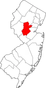 Map of New Jersey highlighting Somerset County | |
| Townships | ||
| CDPs |
| |
| Other communities | ||
| Footnotes | ‡This populated place also has portions in an adjacent county or counties | |
This article is issued from Wikipedia. The text is licensed under Creative Commons - Attribution - Sharealike. Additional terms may apply for the media files.