Hisarcık District
Hisarcık District is a district of the Kütahya Province of Turkey. Its seat is the town of Hisarcık.[1] Its area is 370 km2,[2] and its population is 11,115 (2022).[3]
Hisarcık District | |
|---|---|
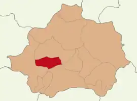 Map showing Hisarcık District in Kütahya Province | |
 Hisarcık District Location in Turkey 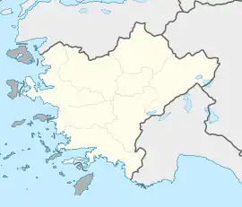 Hisarcık District Hisarcık District (Turkey Aegean) | |
| Coordinates: 39°15′N 29°14′E | |
| Country | Turkey |
| Province | Kütahya |
| Seat | Hisarcık |
| Government | |
| • Kaymakam | İsmail Tosun |
| Area | 370 km2 (140 sq mi) |
| Population (2022) | 11,115 |
| • Density | 30/km2 (78/sq mi) |
| Time zone | TRT (UTC+3) |
| Website | www |
Composition
There is one municipality in Hisarcık District:[1]
There are 25 villages in Hisarcık District:[4]
- Alınören
- Aşağıyoncaağaç
- Beyköy
- Çatak
- Dereköy
- Güldüren
- Halifeler
- Hamamköy
- Hasanlar
- Hocalar
- Karaağıl
- Karbasan
- Kızılçukur
- Kurtdere
- Kutlubeyler
- Kutluhallar
- Ören
- Saklar
- Sefaköy
- Şeyhçakır
- Şeyhler
- Tokat
- Ulaşlar
- Yenipınar
- Yukarıyoncaağaç
References
- İlçe Belediyesi, Turkey Civil Administration Departments Inventory. Retrieved 22 May 2023.
- "İl ve İlçe Yüz ölçümleri". General Directorate of Mapping. Retrieved 22 May 2023.
- "Address-based population registration system (ADNKS) results dated 31 December 2022, Favorite Reports" (XLS). TÜİK. Retrieved 22 May 2023.
- Köy, Turkey Civil Administration Departments Inventory. Retrieved 22 May 2023.
Hisarcık District in Kütahya Province of Turkey | |||||||||||||||||||||||||||
|---|---|---|---|---|---|---|---|---|---|---|---|---|---|---|---|---|---|---|---|---|---|---|---|---|---|---|---|
| Districts |  Districts of Kütahya | ||||||||||||||||||||||||||
| |||||||||||||||||||||||||||
Metropolitan municipalities are bolded. | |||||||||||||||||||||||||||
This article is issued from Wikipedia. The text is licensed under Creative Commons - Attribution - Sharealike. Additional terms may apply for the media files.