Simav District
Simav District is a district of the Kütahya Province of Turkey. Its seat is the town of Simav.[1] Its area is 1,515 km2,[2] and its population is 61,265 (2022).[3]
Simav District | |
|---|---|
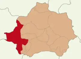 Map showing Simav District in Kütahya Province | |
 Simav District Location in Turkey 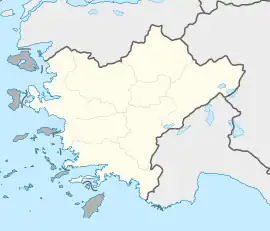 Simav District Simav District (Turkey Aegean) | |
| Coordinates: 39°05′N 28°59′E | |
| Country | Turkey |
| Province | Kütahya |
| Seat | Simav |
| Government | |
| • Kaymakam | Bünyamin Karaloğlu |
| Area | 1,515 km2 (585 sq mi) |
| Population (2022) | 61,265 |
| • Density | 40/km2 (100/sq mi) |
| Time zone | TRT (UTC+3) |
| Website | www |
Composition
There are 7 municipalities in Simav District:[1][4]
There are 83 villages in Simav District:[5]
- Ahlatlıçeşme
- Ahmetli
- Akpınar
- Aksaz
- Aşağıdolaylar
- Bademli
- Bahtıllı
- Başkonak
- Beciler
- Bedirler
- Beyce
- Boğazköy
- Çakırlar
- Çamlık
- Çınarlıdere
- Çulhalar
- Dereköy
- Dereyüzüdere
- Efir
- Eğdemir
- Eğirler
- Esenbağ
- Evciler
- Gılmanlar
- Gökçeler
- Gölköy
- Gümüşsu
- Güzelyurt
- Hacıhüseyinefendi
- Hasanören
- Hıdırdivanı
- Hisarbey
- Ihlamur
- İmranlar
- İnkaya
- İnlice
- Kalkan
- Kapıkaya
- Karacahisar
- Karacaören
- Karakoca
- Karapınar
- Kayaışık
- Kayalıdere
- Kestel
- Kiçir
- Kızılcık
- Köseler
- Koyunoba
- Külcü
- Küplüce
- Kurduman
- Kusumlar
- Maden
- Mamak
- Örencik
- Örenli
- Ortacı
- Pulluca
- Samat
- Sarıçam
- Sarıkaya
- Sarkatlar
- Şenköy
- Söğüt
- Sudöşeği
- Sünnetçiler
- Taşköy
- Taşlık
- Toklar
- Yağıllar
- Yağmurlar
- Yassıeynihan
- Yavu
- Yaykın
- Yemişli
- Yeniköy
- Yeniler
- Yeşilçam
- Yeşildere
- Yeşilköy
- Yeşilyayla
- Yukarıdolaylar
References
- İlçe Belediyesi, Turkey Civil Administration Departments Inventory. Retrieved 22 May 2023.
- "İl ve İlçe Yüz ölçümleri". General Directorate of Mapping. Retrieved 22 May 2023.
- "Address-based population registration system (ADNKS) results dated 31 December 2022, Favorite Reports" (XLS). TÜİK. Retrieved 22 May 2023.
- Belde Belediyesi, Turkey Civil Administration Departments Inventory. Retrieved 22 May 2023.
- Köy, Turkey Civil Administration Departments Inventory. Retrieved 22 May 2023.
Simav District in Kütahya Province of Turkey | |||||||||||||||||||||||||||
|---|---|---|---|---|---|---|---|---|---|---|---|---|---|---|---|---|---|---|---|---|---|---|---|---|---|---|---|
| Districts |  Districts of Kütahya | ||||||||||||||||||||||||||
| |||||||||||||||||||||||||||
Metropolitan municipalities are bolded. | |||||||||||||||||||||||||||
| Municipalities | |
|---|---|
| Villages |
|
This article is issued from Wikipedia. The text is licensed under Creative Commons - Attribution - Sharealike. Additional terms may apply for the media files.