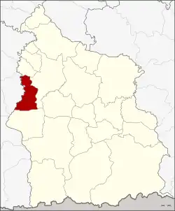
Huai Thap Than district
Huai Thap Than (Thai: ห้วยทับทัน, pronounced [hûa̯j tʰáp tʰān]) is a district (amphoe) in the western part of Sisaket province, northeastern Thailand.
Huai Thap Than
ห้วยทับทัน | |
|---|---|
 District location in Sisaket province | |
| Coordinates: 15°3′0″N 104°1′24″E | |
| Country | Thailand |
| Province | Sisaket |
| Seat | Huai Thap Than |
| Area | |
| • Total | 194.6 km2 (75.1 sq mi) |
| Population (2005) | |
| • Total | 41,132 |
| • Density | 211.4/km2 (548/sq mi) |
| Time zone | UTC+7 (ICT) |
| Postal code | 33210 |
| Geocode | 3312 |
Geography
Neighboring districts are (from the north clockwise): Mueang Chan, Uthumphon Phisai, and Prang Ku of Sisaket Province, and Samrong Thap of Surin province.
History
The minor district (king amphoe) Haui Thap Than was established on 17 January 1977, when the four tambons, Huai Thap Than, Mueang Luang, Phak Mai, and Kluai Kwang, were split off from Uthumphon Phisai district.[1] It started operations on 16 February with a temporary district office in temple (Wat) Phra Charangsan, which was replaced by a permanent office building in 1981. It was upgraded to a full district on 20 March 1986.[2]
Administration
The district is divided into six sub-districts (tambons), which are further subdivided into 80 villages (mubans). Huai Thap Than is a township (thesaban tambon) which covers parts of tambon Huai Thap Than. There are a further six tambon administrative organizations (TAO).
| No. | Name | Thai name | Villages | Pop. | |
|---|---|---|---|---|---|
| 1. | Huai Thap Than | ห้วยทับทัน | 8 | 5,753 | |
| 2. | Mueang Luang | เมืองหลวง | 14 | 8,508 | |
| 3. | Kluai Kwang | กล้วยกว้าง | 13 | 5,678 | |
| 4. | Phak Mai | ผักไหม | 16 | 6,951 | |
| 5. | Chan Saen Chai | จานแสนไชย | 13 | 7,074 | |
| 6. | Prasat | ปราสาท | 16 | 7,168 |
References
- ประกาศกระทรวงมหาดไทย เรื่อง แบ่งท้องที่อำเภออุทุมพรพิสัย จังหวัดศรีสะเกษตั้งเป็นกิ่งอำเภอห้วยทับทัน (PDF). Royal Gazette (in Thai). 94 (10 ง): 365. February 1, 1977. Archived from the original (PDF) on March 24, 2012.
- พระราชกฤษฎีกาตั้งอำเภอคลองลาน อำเภอสุคิริน อำเภอตะโหมด อำเภอห้วยทับทัน และอำเภอปากคาด พ.ศ. ๒๕๒๙ (PDF). Royal Gazette (in Thai). 103 (45 ก special): 4–7. March 20, 1986. Archived from the original (PDF) on February 24, 2012.
