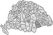
Hunyad County
Hunyad (today mainly Hunedoara) was an administrative county (comitatus) of the Kingdom of Hungary, of the Eastern Hungarian Kingdom and of the Principality of Transylvania. Its territory is now in Romania in Transylvania. The capital of the county was Déva (present-day Deva).
| Hunyad County | |
|---|---|
| County of the Kingdom of Hungary (1265–1526) County of the Eastern Hungarian Kingdom (1526–1570) County of the Principality of Transylvania (1570–1867) County of the Kingdom of Hungary (1867–1920) | |
.svg.png.webp) Coat of arms
| |
 | |
| Capital | Déva |
| Area | |
| • Coordinates | 45°53′N 22°54′E |
• 1910 | 7,809 km2 (3,015 sq mi) |
| Population | |
• 1910 | 340100 |
| History | |
| History | |
• Established | 1265 |
• Treaty of Trianon | 4 June 1920 |
| Today part of | Romania |
| Deva is the current name of the capital. | |
Geography
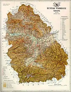
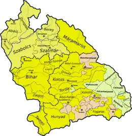
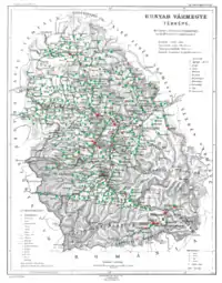
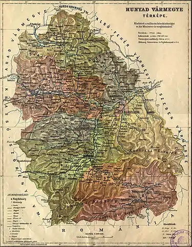
After 1876, Hunyad county shared borders with Romania and the Hungarian counties Krassó-Szörény, Arad, Torda-Aranyos, Alsó-Fehér and Szeben. Its area was 7,809 km2 around 1910.
Etymology
The toponym Hunyad most likely comes from the Hungarian huny verb, meaning 'to close' or 'to die'. According to linguist Géza Kuun, the name may keep the memory of the Huns.[1]
History
The first known civilization living on the territory were the Scythian Agathyrsi and Sigynnae. Later the Dacians under their leader Burebista established solid control over the territory, but were conquered and massacred by the Roman Empire. Hunyad was part of Roman Dacia for a short time, but by the 3rd century it was occupied by the Goths, later by the Vandals and Gepids. The nomadic Avars conquered Transylvania in 567, and remained the ethnic majority even after the collapse of their khaganate. The Igech, Szerekes, Andos and Zeyk noble families are all of Avar origin, along with the name of the river Zsil.[2]
Hunyad county was formed in the Middle Ages. It was first attested in 1265 as Hungnod by the Papal Quitrent Register. In 1876, when the administrative structure of Transylvania was changed, its territory was modified to include about two thirds of the former Zaránd County (Brád/Brad and Körösbánya/Baia de Criș districts) and the Saxon seat of Broos/Orăștie. In 1920, by the Treaty of Trianon, the county became part of Romania. Most of its territory lies in the present Romanian county Hunedoara; a strip in the east is now part of Alba and a strip in the west is now part of Caraș-Severin County (the commune Băuţar).
Demographics
| Census | Total | Romanian | Hungarian | German | Other or unknown |
|---|---|---|---|---|---|
| 1880[3] | 248,464 | 217,414 (90.28%) | 12,278 (5.10%) | 6,968 (2.89%) | 4,166 (1.73%) |
| 1890[4] | 267,895 | 238,486 (89.02%) | 17,167 (6.41%) | 8,047 (3.00%) | 4,195 (1.57%) |
| 1900[5] | 303,838 | 257,013 (84.59%) | 32,316 (10.64%) | 9,189 (3.02%) | 5,320 (1.75%) |
| 1910[6] | 340,135 | 271,675 (79.87%) | 52,720 (15.50%) | 8,101 (2.38%) | 7,639 (2.25%) |
| Census | Total | Eastern Orthodox | Greek Catholic | Roman Catholic | Calvinist | Jewish | Lutheran | Other or unknown |
|---|---|---|---|---|---|---|---|---|
| 1880 | 248,464 | 177,725 (71.53%) | 48,381 (19.47%) | 11,883 (4.78%) | 6,568 (2.64%) | 1,996 (0.80%) | 1,799 (0.72%) | 112 (0.05%) |
| 1890 | 267,895 | 190,018 (70.93%) | 50,520 (18.86%) | 15,121 (5.64%) | 7,351 (2.74%) | 2,470 (0.92%) | 2,202 (0.82%) | 213 (0.08%) |
| 1900 | 303,838 | 204,350 (67.26%) | 55,116 (18.14%) | 24,993 (8.23%) | 11,398 (3.75%) | 4,056 (1.33%) | 3,269 (1.08%) | 656 (0.22%) |
| 1910 | 340,135 | 217,425 (63.92%) | 60,024 (17.65%) | 34,668 (10.19%) | 16,675 (4.90%) | 5,679 (1.67%) | 4,110 (1.21%) | 1,554 (0.46%) |
Subdivisions
In the early 20th century, the subdivisions of Hunyad County were:
| Districts (járás) | |
|---|---|
| District | Capital |
| Algyógy | Algyógyalfalu (now Geoagiu) |
| Brád | Brád (now Brad) |
| Déva | Déva (now Deva) |
| Hátszeg | Hátszeg (now Hațeg) |
| Kőrösbánya | Kőrösbánya (now Baia de Criș) |
| Marosillye | Marosillye (now Ilia) |
| Petrozsény | Petrozsény (now Petroșani) |
| Puj | Puj (now Pui) |
| Szászváros | Szászváros (now Orăștie) |
| Vajdahunyad | Vajdahunyad (now Hunedoara) |
| Urban districts (rendezett tanácsú város) | |
| Déva (now Deva) | |
| Hátszeg (now Hațeg) | |
| Szászváros (now Orăștie) | |
| Vajdahunyad (now Hunedoara) | |
Notes
- Only linguistic communities > 1% are displayed.
- Only religious communities > 1% are displayed.
References
- Kuun, Géza; Torma, Zsófia; Téglás, Gábor (1902). "Hunyadvármegye története" [The history of Hunyad County]. Irodalmi Szemle (in Hungarian). Budapest. I: 353.
- Kuun, Géza; Torma, Zsófia; Téglás, Gábor (1902). "Hunyadvármegye története" [The history of Hunyad County]. Irodalmi Szemle (in Hungarian). Budapest. I.
- "Az 1881. év elején végrehajtott népszámlálás főbb eredményei megyék és községek szerint rendezve, II. kötet (1882)". library.hungaricana.hu. Retrieved 28 September 2021.
- "A Magyar Korona országainak helységnévtára (1892)". library.hungaricana.hu. Retrieved 29 September 2021.
- "A MAGYAR KORONA ORSZÁGAINAK 1900". library.hungaricana.hu. Retrieved 29 September 2021.
- "KlimoTheca :: Könyvtár". Kt.lib.pte.hu. Retrieved 29 September 2021.
