Alsó-Fehér County
Alsó-Fehér was an administrative county (comitatus) of the Kingdom of Hungary. Its territory is now in western Romania (central Transylvania). The latest capital of the county was Nagyenyed (present-day Aiud).
| Alsó-Fehér County | |
|---|---|
| County of the Principality of Transylvania (1744-1867) County the Kingdom of Hungary (1867-1920) | |
 Coat of arms
| |
 | |
| Capital | Gyulafehérvár; Nagyenyed (1876-1920) |
| Area | |
| • Coordinates | 46°19′N 23°44′E |
• 1910 | 3,576.5 km2 (1,380.9 sq mi) |
| Population | |
• 1910 | 221618 |
| History | |
| History | |
• Established | 1744 |
| 4 June 1920 | |
| Today part of | Romania |
| Alba Iulia; Aiud are the current name of the capital. | |
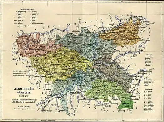
Geography

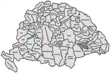
Alsó-Fehér county shared borders with Hunyad, Torda-Aranyos, Kis-Küküllő, Nagy-Küküllő and Szeben counties. The rivers Mureș and Târnava flowed through the county. Its area was 3,576.5 km2 around 1910.
History
Alsó-Fehér (Lower Fehér) county was formed when Fehér county was split in 1744 (the other half, Felső-Fehér county, consisted entirely of enclaves between Székely and Saxon seats). In 1876, when the administrative structure of Transylvania was changed, the territory of Alsó-Fehér was modified and parts of it were annexed to the counties of Torda-Aranyos and Seben (during the same administrative reform, Felső-Fehér county was entirely abolished and merged with other counties). In 1920, the Treaty of Trianon assigned the territory of the county to Romania. Its territory lies in the present Romanian counties of Alba, Sibiu (the south-east) and Mureș (a small northeastern part).
Demographics
| Census | Total | Romanian | Hungarian | German | Other or unknown |
|---|---|---|---|---|---|
| 1880[1] | 178,021 | 135,439 (78.79%) | 25,818 (15.02%) | 6,972 (4.06%) | 3,667 (2.13%) |
| 1890[2] | 193,072 | 151,397 (78.41%) | 30,181 (15.63%) | 7,539 (3.90%) | 3,955 (2.05%) |
| 1900[3] | 212,352 | 166,099 (78.22%) | 36,360 (17.12%) | 7,953 (3.75%) | 1,940 (0.91%) |
| 1910[4] | 221,618 | 171,483 (77.38%) | 39,107 (17.65%) | 7,269 (3.28%) | 3,759 (1.70%) |
| Census | Total | Eastern Orthodox | Greek Catholic | Calvinist | Roman Catholic | Lutheran | Jewish | Other or unknown |
|---|---|---|---|---|---|---|---|---|
| 1880 | 178,021 | 76,165 (42.78%) | 66,714 (37.48%) | 16,834 (9.46%) | 8,551 (4.80%) | 5,961 (3.35%) | 2,806 (1.58%) | 990 (0.56%) |
| 1890 | 193,072 | 80,353 (41.62%) | 74,132 (38.40%) | 19,472 (10.09%) | 8,943 (4.63%) | 5,813 (3.01%) | 3,280 (1.70%) | 1,079 (0.56%) |
| 1900 | 212,352 | 87,210 (41.07%) | 80,211 (37.77%) | 21,296 (10.03%) | 11,226 (5.29%) | 7,170 (3.38%) | 3,903 (1.84%) | 1,336 (0.63%) |
| 1910 | 221,618 | 89,724 (40.49%) | 85,276 (38.48%) | 23,009 (10.38%) | 11,194 (5.05%) | 7,283 (3.29%) | 3,845 (1.73%) | 1,287 (0.58%) |
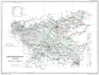
Subdivisions
In the early 20th century, the subdivisions of Alsó-Fehér county were:
| Districts (járás) | |
|---|---|
| District | Capital |
| Alvinc | Alvinc (now Vințu de Jos) |
| Balázsfalva | Balázsfalva (now Blaj) |
| Kisenyed | Kisenyed (now Ocna Sibiului) |
| Magyarigen | Magyarigen (now Ighiu) |
| Marosújvár | Marosújvár (now Ocna Mureș) |
| Nagyenyed | Nagyenyed (now Aiud) |
| Tövis (from 1908) | Tövis (now Teiuș) |
| Verespatak | Verespatak (now Roșia Montană) |
| Urban districts (rendezett tanácsú városok) | |
| Abrudbánya (now Abrud) | |
| Gyulafehérvár (now Alba Iulia) | |
| Nagyenyed (now Aiud) | |
| Vízakna (now Ocna Sibiului) | |
Notes
- Only linguistic communities > 1% are displayed.
- Only religious communities > 1% are displayed.
References
- "Az 1881. év elején végrehajtott népszámlálás főbb eredményei megyék és községek szerint rendezve, II. kötet (1882)". library.hungaricana.hu. Retrieved 2021-09-28.
- "A Magyar Korona országainak helységnévtára (1892)". library.hungaricana.hu. Retrieved 2021-09-29.
- "A MAGYAR KORONA ORSZÁGAINAK 1900". library.hungaricana.hu. Retrieved 2021-09-29.
- "KlimoTheca :: Könyvtár". Kt.lib.pte.hu. Retrieved 2021-09-29.
