Torda-Aranyos County
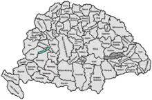
Torda-Aranyos was an administrative county (comitatus) of the Kingdom of Hungary. Its territory is now in central Romania (central Transylvania). The capital of the county was Torda (present-day Turda).
| Torda-Aranyos County | |
|---|---|
| County of the Kingdom of Hungary | |
| 1876–1920 | |
.svg.png.webp) Coat of arms
| |
 | |
| Capital | Torda |
| Area | |
| • Coordinates | 46°34′N 23°47′E |
• 1910 | 3,514 km2 (1,357 sq mi) |
| Population | |
• 1910 | 174400 |
| History | |
| History | |
• Established | 1876 |
• Treaty of Trianon | June 4 1920 |
| Today part of | Romania |
| Turda is the current name of the capital. | |
Geography
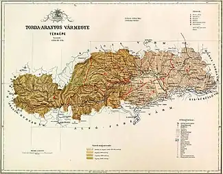
Torda-Aranyos county shared borders with the Hungarian counties Arad, Bihar, Kolozs, Maros-Torda, Kis-Küküllő, Alsó-Fehér and Hunyad. The rivers Mureș and Arieș flowed through the county. Its area was 3,514 km2 around 1910.
History
Torda-Aranyos county was formed in 1876, when the western part of the Torda County and the Székely seat of Aranyosszék (plus small parts of Alsó-Fehér County) were united. In 1920, by the Treaty of Trianon, the county became part of Romania. Its territory lies in the present Romanian counties of Cluj (the north, including Turda), Alba (the south and west) and Mureș (the east).
Demographics
| Census | Total | Romanian | Hungarian | Other or unknown |
|---|---|---|---|---|
| 1880[1] | 137,031 | 96,809 (73.15%) | 30,472 (23.02%) | 5,063 (3.83%) |
| 1890[2] | 150,564 | 107,491 (71.39%) | 37,590 (24.97%) | 5,483 (3.64%) |
| 1900[3] | 160,579 | 116,833 (72.76%) | 40,806 (25.41%) | 2,940 (1.83%) |
| 1910[4] | 174,375 | 125,668 (72.07%) | 44,630 (25.59%) | 4,077 (2.34%) |
| Census | Total | Greek Catholic | Eastern Orthodox | Calvinist | Unitarian | Roman Catholic | Jewish | Other or unknown |
|---|---|---|---|---|---|---|---|---|
| 1880 | 137,031 | 56,169 (40.99%) | 47,050 (34.34%) | 18,781 (13.71%) | 8,991 (6.56%) | 4,390 (3.20%) | 1,355 (0.99%) | 295 (0.22%) |
| 1890 | 150,564 | 62,023 (41.19%) | 49,131 (32.63%) | 22,506 (14.95%) | 9,480 (6.30%) | 5,253 (3.49%) | 1,931 (1.28%) | 240 (0.16%) |
| 1900 | 160,579 | 66,293 (41.28%) | 52,457 (32.67%) | 23,607 (14.70%) | 10,005 (6.23%) | 5,490 (3.42%) | 2,465 (1.54%) | 262 (0.16%) |
| 1910 | 174,375 | 72,672 (41.68%) | 56,748 (32.54%) | 25,526 (14.64%) | 9,932 (5.70%) | 6,539 (3.75%) | 2,357 (1.35%) | 310 (0.18%) |
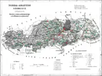
Subdivisions
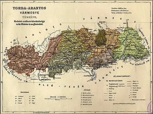
In the early 20th century, the subdivisions of Torda-Aranyos county were:
| Districts (járás) | |
|---|---|
| District | Capital |
| Alsójára | Alsójára (now Iara) |
| Felvinc | Felvinc (now Unirea) |
| Marosludas | Marosludas (now Luduș) |
| Topánfalva | Topánfalva (now Câmpeni) |
| Turda | Torda (now Turda) |
| Torockó | Torockó (now Rimetea) |
| Urban districts (rendezett tanácsú város) | |
| Torda (now Turda) | |
See also
Notes
- Only linguistic communities > 1% are displayed.
- Only religious communities > 1% are displayed.
References
- "Az 1881. év elején végrehajtott népszámlálás főbb eredményei megyék és községek szerint rendezve, II. kötet (1882)". library.hungaricana.hu. Retrieved September 28, 2021.
- "A Magyar Korona országainak helységnévtára (1892)". library.hungaricana.hu. Retrieved September 29, 2021.
- "A MAGYAR KORONA ORSZÁGAINAK 1900". library.hungaricana.hu. Retrieved September 29, 2021.
- "KlimoTheca :: Könyvtár". Kt.lib.pte.hu. Retrieved September 29, 2021.
