Imereti
Imereti (Georgian: იმერეთი) is a region of Georgia situated in the central-western part of the republic along the middle and upper reaches of the Rioni River. Imereti is the most populous region in Georgia. It consists of 11 municipalities and the city of Kutaisi, which is the capital of the region.
Imereti
იმერეთი | |
|---|---|
From the top to bottom-right: Kutaisi, Okatse Canyon, Katskhi Pillar, Sulori Gorge, Tkibuli Reservoir | |
.svg.png.webp) Overlapping borders of de jure Imereti region and de facto South Ossetia[nt 1] | |
| Country | |
| Capital | Kutaisi |
| Government | |
| • Governor | Zviad Shalamberidze[1] (Georgian Dream) |
| Area | |
| • Total | 6,680 km2 (2,580 sq mi) |
| Population (2021)[3] | |
| • Total | 481,473 |
| • Density | 72/km2 (190/sq mi) |
| ISO 3166 code | GE-IM |
| Districts | 11 districts, 1 city |
| HDI (2017) | 0.810 [4] very high · 3rd |
| Website | imereti.ge |


.jpg.webp)
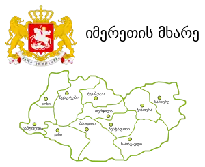
Subdivisions
The Imereti region has one self governing city (Kutaisi) and 11 municipalities with 163 administrative communities (temi), totalling to 549 populated settlements:
- Eleven cities: Baghdati, Chiatura, Khoni, Kutaisi, Sachkhere, Samtredia, Terjola, Tqibuli, Tsqaltubo, Vani and Zestafoni;
- Three dabas: Kharagauli, Kulashi and Shorapani;
- Villages: 535
Economy
Aside from the capital Kutaisi, significant towns and regional centres include Samtredia, Chiatura (manganese production centre), Tkibuli (coal mining centre), Zestafoni (known for metals production), Vani, Khoni, and Sachkhere. Traditionally, Imereti is an agricultural region, known for its mulberries and grapes.
Demographics
The 800,000 Imeretians speak a Georgian dialect; they are one of the local culture-groups of the ethnically subdivided Georgian people.
Demographic
| Population development of the region Samegrelo-Zemo Svaneti[5] | ||||||||||||||||||
|---|---|---|---|---|---|---|---|---|---|---|---|---|---|---|---|---|---|---|
| 1959 | 1970 | 1979 | 1989 | 2002* | 2002** | 2014 | 2021 | |||||||||||
| Imereti | ||||||||||||||||||
| City of Kutaisi | - | |||||||||||||||||
| Baghdati Municipality | - | |||||||||||||||||
| Chiatura Municipality | - | |||||||||||||||||
| Kharagauli Municipality | - | |||||||||||||||||
| Khoni Municipality | - | |||||||||||||||||
| Sachkhere Municipality*** | - | |||||||||||||||||
| Samtredia Municipality | - | |||||||||||||||||
| Terjola Municipality | - | |||||||||||||||||
| Tqibuli Municipality | - | |||||||||||||||||
| Tsqaltubo Municipality | - | |||||||||||||||||
| Vani Municipality | - | |||||||||||||||||
| Zestafoni Municipality | - | |||||||||||||||||
| * Research after 2014 census showed the 2002 census was inflated by 8-9 percent.[6] **Corrected data based on retro-projection 1994-2014 in collaboration with UN[7] *** Part of Sachkhere is outside Georgian government authority and has not been counted since 2002. | ||||||||||||||||||
History
.jpg.webp)
Anciently the region was a part of Colchis, and included in Lazia during the Roman empire. Then called Imeretia, it was nominally under the dominion of the Byzantine Empire. In the early part of the 6th century it became the theatre of wars between the emperor Justinian I and Khosrow I, king of Persia.[8]
In late antiquity and early Middle Ages the ancient western Georgian kingdom of Egrisi existed on the territory of Imereti. Its king declared Christianity as an official religion of Egrisi in 523 AD.
Between 750 and 985 it was ruled by a dynasty of native princes, but was devastated by hostile incursions, reviving only after it became united to Georgia,[8] and until 1466 Imereti was part of the united Georgian Kingdom. Since that kingdom's disintegration in the 15th century, Imereti was an independent kingdom.
In the 17th–18th centuries, the kingdom of Imereti experienced frequent invasions by the Turks and paid patronage to the Ottoman Empire until 1810, when it was invaded and annexed by the Russian Empire. The last King of Imereti was Solomon II (1789–1810).
From 1918 to 1921, Imereti was part of the independent Democratic Republic of Georgia. Within the USSR, the region was part of the Transcaucasian SFSR from 1922–1936, and part of the Georgian SSR from 1936–1991. Since Georgian independence in 1991, Imereti has been a region of Georgia with Kutaisi as the regional capital.
Notes
- South Ossetia's status is disputed. It considers itself to be an independent state, but this is recognised by only a few other countries. The Georgian government and most of the world's other states consider South Ossetia de jure a part of Georgia's territory.
References
- "New Governor of Imereti Appointed".
- Nominal area 6,680 km², de facto controlled by Georgia 6,415 km².
- "Population and Demography - Population by cities and boroughs as of 1 January". National Statistics Office of Georgia (Geostat). Retrieved 2021-11-26.
- "Sub-national HDI - Area Database - Global Data Lab". hdi.globaldatalab.org. Retrieved 2018-09-13.
- "Divisions of Georgia". Population Statistics Eastern Europe and former USSR. Retrieved 2022-02-04.
- "Population Dynamics in Georgia - An Overview Based on the 2014 General Population Census Data" (PDF). National Statistics Office of Georgia, Geostat. 2017-11-29. pp. 1–4. Retrieved 2022-02-04.
- "Retro-projection of main demographic indicators for the period 1994-2014". National Statistics Office of Georgia, Geostat. 2018-05-18. pp. 3, Table 1. Retrieved 2022-02-04.
- One or more of the preceding sentences incorporates text from a publication now in the public domain: Chisholm, Hugh, ed. (1911). "Imeretia". Encyclopædia Britannica. Vol. 14 (11th ed.). Cambridge University Press. p. 331.
External links
| ||||||||||||||||||||||||||||||||||||||||||
.svg.png.webp)