U.S. Route 23 in Tennessee
U.S. Route 23 (US 23) is a part of the United States Numbered Highway System that travels from Jacksonville, Florida, to Mackinaw City, Michigan. In the U.S. state of Tennessee, the highway travels 57.5 miles (92.5 km) in the northeastern part of the state from the North Carolina state line at Sam's Gap in the Bald Mountains, north to the Virginia state line in Kingsport. With a predominant concurrency with Interstate 26 (I-26), US 23 is a divided four-lane freeway that follows Corridor B of the Appalachian Development Highway System (ADHS) and serves as a major thoroughfare in the Tri-Cities. Although I-26 is technically an east–west route, the highway predominantly travels in a north–south alignment in Tennessee. The route reaches a maximum elevation of 3,760 feet (1,150 m) at the North Carolina state line, which is the highest elevation on the Interstate Highway System east of the Mississippi River.
U.S. Route 23 | ||||||||||
|---|---|---|---|---|---|---|---|---|---|---|
| James H. Quillen Parkway | ||||||||||
I-26/US 23 concurrency in purple and US 23 in red | ||||||||||
| Route information | ||||||||||
| Maintained by TDOT | ||||||||||
| Length | 57.5 mi[1] (92.5 km) The length of I-26 is 54.45 miles (87.63 km).[2] | |||||||||
| Existed | May 26, 1930[3]–present | |||||||||
| History |
| |||||||||
| Major junctions | ||||||||||
| South end | ||||||||||
| North end | ||||||||||
| Location | ||||||||||
| Country | United States | |||||||||
| State | Tennessee | |||||||||
| Counties | Unicoi, Carter, Washington, Sullivan | |||||||||
| Highway system | ||||||||||
| ||||||||||

The freeway was first authorized by the Appalachian Regional Development Act of 1965, which created the ADHS, and the stretch between Johnson City and the Virginia state line was constructed in segments between 1968 and 1986. In addition to US 23, this freeway was designated as State Route 137 (SR 137) and later Interstate 181 (I-181), and was commonly referred to as "Appalachian Highway" in its early years. In 1988, the American Association of State Highway and Transportation Officials (AASHTO) approved an extension of I-26 from Asheville, North Carolina, to I-81 in Tennessee. The remainder of the freeway was completed in 1995, and the stretch between the North Carolina state line and I-81 was redesignated as I-26 in 2003. After an initial denial, I-26 was extended north to Kingsport in 2007, replacing the remainder of I-181.
Route description
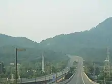
The freeway begins at the Virginia state line at a partial interchange with SR 36 (the old route of US 23) and SR 346, where the route continues into Virginia as a four-lane divided highway. Here, a pair of one-lane ramps carry US 23 and unsigned SR 137 across both routes; SR 346 is not directly accessible from the freeway, and the southbound lanes are indirectly accessible from SR 23 via an entrance ramp from SR 346. Here, the freeway curves to the southwest, and then to the southeast a short distance later, zigzagging over the next few miles through a predominantly residential area on the outskirts of Kingsport. The freeway then reaches a partial cloverleaf interchange with US 11W, where I-26 begins, and transitions into a more direct north–south alignment. The Interstate immediately crosses the Holston River, which is split into two channels here by a wide island called Long Island, on a long pair of viaducts. It then begins a steep ascent over the north end of Bays Mountain, where the eastbound lanes utilize a truck climbing lane. Passing through a deep artificial cut at the top of the mountain, the route then begins a descent, where the westbound lanes also contain a truck lane. A short distance later, the Interstate reaches a partial cloverleaf interchange with SR 93 (John B. Dennis Bypass), which continues to the north as a controlled-access bypass of Kingsport.
Leaving Kingsport, I-26 continues over the next several miles southeastwardly through a semi-residential area, crossing several ridges characteristic of the topography of the area, and curving sharply to the west and then back to the east. It then reaches I-81 at a cloverleaf interchange near the Colonial Heights community. It then curves back into a northwest-to-southeast alignment, passing a mix of farmland and rural residential areas over the next five miles (8.0 km), before reaching an interchange with SR 75 in the Gray community. The Interstate continues over the next four miles (6.4 km) through additional farmland and neighborhoods, before reaching an interchange with SR 354, which provides access to Jonesborough to the southwest. A short distance later, the freeway enters the western part of Johnson City, where it has in interchange with SR 381, which serves as a western bypass of the city and also provides access to Bristol. About one mile (1.6 km) later, the Interstate has a near-full cloverleaf interchange with US 11E and US 19W (Roan Street), where it begins a concurrency with the latter. It then continues over the next few miles through a dense residential area, before passing near the business district of Johnson City, where it has interchanges with SR 400 and SR 19 in short succession. A short distance later, the freeway reaches an interchange with US 321 and SR 67, which provides access to East Tennessee State University, as well as Elizabethton to the northeast. Beyond this point, the Interstate passes through the mostly residential southern tip of Johnson City along the northern base of Buffalo Mountain, where it gradually transitions into a more direct north–south alignment and enters the Blue Ridge Mountains. Leaving Johnson City, the Interstate then briefly passes Carter County and gradually begins to curve to the southwest, entering a valley between Buffalo Mountain to the west and the Bald Mountains subrange to the east.
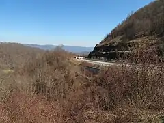
I-26 continues over the next several miles in a relatively straight alignment, where it passes the town of Unicoi. A few miles later, the Interstate reaches Erwin, where it has interchanges with the northern terminus of SR 81. The route then runs along the bank of the Nolichucky River for about one mile (1.6 km), before crossing that river and leaving Irwin. Meandering through a valley that is even narrower at this point, the route reaches an interchange a few miles later where US 19W splits off. The Interstate then begins a gradual uphill climb at this point, with the speed limit reducing to 60 miles per hour (97 km/h) and 55 miles per hour (89 km/h) for trucks, and reaches an elevation of 2,000 feet (610 m) a short distance later. Shortly beyond this point is an interchange with a local road, which also contains the westbound Tennessee Welcome Center. A short distance beyond this point is a westbound scenic overlook, where the route briefly flattens out before beginning an even steeper climb near the Flag Pond community, where the speed limit reduces to 55 miles per hour (89 km/h) and 50 miles per hour (80 km/h) for trucks. Over then next 4.5 miles (7.2 km), where the Interstate surpasses 3,000 feet (910 m), the westbound lanes utilize two runaway truck ramps, and westbound trucks are advised to reduce their speed to between 45 and 20 miles per hour (72 and 32 km/h), depending on their weight. This stretch also passes through multiple artificial rock cuts where mesh fences and retaining walls are used to mitigate the effects of rockslides, and crosses three stream valleys on long viaducts, which also act as wildlife underpasses. Near the top of this ascent is an eastbound scenic overlook. About 0.5 miles (0.80 km) later, the Interstate reaches Sam's Gap, where the westbound lanes contain a large truck inspection and parking station, and crosses into North Carolina.
History
Background and early history
A proposal to construct a road between Johnson City and Asheville, North Carolina, existed as early as 1919.[4] US 23 was established by the American Association of State Highway Officials (AASHO) on May 26, 1930, with a complete concurrency with SR 36, from the North Carolina state line to the Virginia state line; going through Erwin, Unicoi, Johnson City, and Kingsport.[3][5] Signs were posted later that year.[6] The final section in Tennessee to be paved, located between Kingsport and the Virginia state line, opened to traffic on July 8, 1931.[7] The highway was dedicated by Governor Henry Horton in a large ceremony near the Sullivan–Washington county line on July 17, 1931.[8]
In 1952, US 23 was rerouted southwest of Ernestville, along SR 81 through Flag Pond and Sam's Gap into North Carolina; its old alignment remained part of US 19W/SR 36.
Appalachian Development Highway System and Interstate Highway era

The widening of US 23 to a four-lane highway between Asheville, North Carolina, and Johnson City, Tennessee, was authorized by the Appalachian Regional Development Act of 1965, which created the ADHS. This stretch was designated as part of Corridor B, and the project was known as Project A-10.[9] The first contract for construction was awarded on February 23, 1968, for the 3.1 miles (5.0 km) stretch between I-81 and near the Gray community.[10] On January 9, 1971, the segment of this highway located between SR 75 in Gray and SR 354 near Johnson City was opened.[11][12] The segment between SR 354 and SR 381 opened on November 17, 1972.[13] On July 1, 1975, the stretch between US 11W/US 19 and SR 19 (Market Street) in Johnson City opened.[14] The section between SR 19 and south of US 321/SR 67 south of Johnson City was opened to northbound traffic on October 23, 1978, and to southbound traffic the following day, after nearly 16 months of delays.[15][16] On November 13, 1981, the stretch between SR 93 and US 11W in Kingsport was dedicated and opened.[17] The segment around Erwin between south of the Nolichucky River and north of Main Street, known at the time as the Erwin Bypass, opened on January 29, 1982.[18][19] That same month, contracts were awarded for the stretch between south of US 321/SR 67 and Main Street in Erwin,[19] and the stretch was dedicated and opened on June 20, 1986, after multiple delays.[20][21]
While Tennessee continued to appropriate funds to construct the highway between Erwin and the Virginia state line, funds for ADHS corridors began lagging in the 1970s, and, by the end of that decade, plans to upgrade the stretch over the Bald Mountains had largely stalled.[9] State Representative Zane Whitson of Erwin, who was elected in 1978, campaigned on reviving the project,[22] but it remained largely dormant until August 1985, when two planners from Johnson City suggested renumbering the route to I-181 in order to make the highway eligible for additional federal funds.[9] In 1986, the extension through the Bald Mountains was included as one of six new freeway projects dubbed "Bicentennial Parkways" in the Better Roads Program, passed by the Tennessee General Assembly.[23] This program, which had been proposed and spearheaded by then-Governor Lamar Alexander, increased the state's gasoline and diesel taxes to fund these freeway projects as well as a backlog of 15 projects that had been labeled as top priorities and other projects.[24] The project was referred to in the plan as the "Interstate 181 Extension" and was expected to cost $95.5 million (equivalent to $203 million in 2021[25]) at the time.[23] The project was further accelerated the following year by then-new Governor Ned McWherter.[22]
The contract for the first section of the extension, 4.6 miles (7.4 km) between south of the Nolichucky River and near the Temple Hill Community, was awarded on February 16, 1990. On May 1, 1990, a groundbreaking ceremony was held, officiated by Governor McWherter.[26] The section between Temple Hill and Flag Pond was awarded on January 2, 1991, and the 2.8-mile (4.5 km) section between Flag Pond and Carver Road, near the southernmost runaway truck ramp, was awarded on May 21, 1991.[4] Due to the mountainous setting, the project proved to be one of the most difficult and laborious projects ever undertaken by the Tennessee Department of Transportation (TDOT) and required nearly 25 million cubic yards (19×106 m3) of rock and dirt to be moved.[27] In September 1992, a lawsuit was jointly filed against TDOT by the Tennessee Environmental Council, the Tennessee Chapter of the Sierra Club, the Tennessee Scenic Rivers Association, and the Good Earth Defense Fund alleging violations of the National Environmental Policy Act and the Clean Water Act.[28][29] The suit was dropped when TDOT agreed to modify the design of the highway in order to be more environmentally conscious, which included additional erosion control measures and the construction of two wildlife underpass tunnels, nicknamed "bear boxes", under the highway.[30] They also agreed to set up an environmental advisory agency for the department.[31] On December 24, 1993, the section between the Nolichucky River and US 19W opened.[32] On July 5, 1995, the final section opened to traffic in a dedication ceremony at Sam's Gap officiated by then-Governor Don Sundquist, former Governor McWherter, and Congressman Quillen, along with other state officials.[33][34] The final cost of the extension was $170 million (equivalent to $280 million in 2021[25]).[35]
Designation history

State Route 137 | |
|---|---|
| Location | Kingsport, Tennessee–Virginia state line |
| Length | 3.0 mi[36][37] (4.8 km) |
| Existed | 1970–present |
Interstate 181 | |
|---|---|
| Location | Johnson City–Kingsport |
| Length | 23.85 mi[38] (38.38 km) |
| Existed | 1985–2007 |
Interstate 26 | |
|---|---|
| Location | North Carolina state line–Kingsport, Tennessee |
| Length | 54.4 mi[39] (87.5 km) |
| Existed | August 5, 2003[40]–present |
The controlled-access highway that ran between Johnson City and Kingsport was initially established as State Route 137 (SR 137), with this designation extended as new sections were completed. On June 28, 1982, AASHTO approved rerouting US 23 onto the freeway from its original alignment with SR 36, forming a concurrency with SR 137.[41] On December 4, 1985, the stretch between I-81 and US 11W in Kingsport was renumbered Interstate 181 (I-181). The I-181 designation was extended south to US 321/SR 67 in Johnson City on June 9, 1986.[42] Both of these redesignations replaced SR 137 but kept the US 23 designation, and exits were numbered according to US 23's mileage. This reduced SR 137 to its present-day designation between US 11W and the Virginia state line, all within Kingsport.[37]
On June 7, 1988, AASHTO approved an extension of I-26 from North Carolina to I-81, on contingent upon the completion and certification of the freeway.[43] On August 5, 2003, after completion of a nine-mile (14 km) adjacent section of controlled-access highway in North Carolina, I-26 was extended west into Tennessee, replacing I-181 from Johnson City to I-81.[40] AASHTO initially ruled against an extension of the I-26 designation along the remainder of I-181 to Kingsport, however, since federal guidelines usually require mainline Interstate Highways to end at a junction with another Interstate Highway, an international border, or a seacoast.[44] TDOT had proposed to renumber that stretch as I-126, but rescinded that proposal later that year.[45] The Safe, Accountable, Flexible, Efficient Transportation Equity Act: A Legacy for Users (SAFETEA-LU), signed into law on August 10, 2005, authorized the remainder of I-181 to be redesignated as part of I-26.[46] This took place in March 2007, when I-181 was officially decommissioned, and replaced with I-26 signage.[47][48][49]
Exit list
Old exit numbers were based on US 23 distances; new exit numbers are based on I-26 milemarkers.
| County | Location | mi[1][39] | km | Old exit | New exit | Destinations | Notes |
|---|---|---|---|---|---|---|---|
| Unicoi | | 54.4 | 87.5 | Continuation from North Carolina through Sam's Gap | |||
| | 49.9 | 80.3 | 5 | 50 | Flag Pond Road – Flag Pond | ||
| | 46.3 | 74.5 | 9 | 46 | Clear Branch Road – TN Welcome Center | ||
| Temple Hill | 43.5 | 70.0 | 12 | 43 | Southern end of US 19W concurrency | ||
| Erwin | 39.8 | 64.1 | 15 | 40 | Jackson-Love Highway – Erwin | ||
| 37.2 | 59.9 | 18 | 37 | Southern terminus of SR 81 | |||
| 35.7 | 57.5 | 19 | 36 | Harris Hollow Road to | |||
| Unicoi | 33.7 | 54.2 | 21 | 34 | Tinker Road – Unicoi | ||
| 31.8 | 51.2 | 23 | 32 | ||||
| Carter | Johnson City | 27.0 | 43.5 | 28 | 27 | ||
| Washington | 23.8 | 38.3 | 31 | 24 | |||
| 23.0 | 37.0 | 32 | 23 | ||||
| 22.3 | 35.9 | 33 | 22 | ||||
| 20.2 | 32.5 | 35 | 20 | Northern end of US 19W concurrency; signed as exits 20A (south) and 20B (north) westbound | |||
| 19.0 | 30.6 | 36 | 19 | ||||
| 16.7 | 26.9 | 38 | 17 | ||||
| Gray | 13.1 | 21.1 | 42 | 13 | |||
| Sullivan | Kingsport | 9.9 | 15.9 | 45 | 10 | Eastern Star Road | |
| 8.5 | 13.7 | 46 | 8 | Signed as exits 8A (south) and 8B (north) | |||
| 6.3 | 10.1 | 49 | 6 | ||||
| 4.0 | 6.4 | 51 | 4 | Signed as exits 4A (south) and 4B (north) eastbound | |||
| 3.5 | 5.6 | 52 | 3 | Meadowview Parkway | |||
| 0.0 | 0.0 | 55 | 1 | Western terminus of I-26; northern end of I-26 concurrency; southern terminus of SR 137; southern end of SR 137 concurrency | |||
| Virginia state line | 57.3– 57.5 | 92.2– 92.5 | 57 | — | Northbound left entrance extends into Virginia; left exit southbound | ||
| Continuation into Virginia | |||||||
1.000 mi = 1.609 km; 1.000 km = 0.621 mi
| |||||||
References
- Google (November 11, 2015). "U.S. Route 23 in Tennessee" (Map). Google Maps. Google. Retrieved November 11, 2015.
- Starks, Edward (January 27, 2022). "Table 1: Main Routes of the Dwight D. Eisenhower National System of Interstate and Defense Highways". FHWA Route Log and Finder List. Federal Highway Administration. Retrieved September 18, 2023.
- Executive Committee (May 26, 1930). "Minutes of Executive Committee" (PDF) (Report). Washington, DC: American Association of State Highway Officials. p. 4. Retrieved September 17, 2023 – via Wikimedia Commons.
- Crawford, Carole (July 4, 1995). "Improvement effort has long history". The Erwin Record, Johnson City Press. p. 3. Retrieved November 13, 2022 – via Newspapers.com.
- Shell Highway Map of Kentucky Tennessee (PDF) (Map). Cartography Associates, David Rumsey Collection. 1956. Retrieved November 11, 2015.
- "Markers Are Being Placed On Federal Highway No. 23 Which Runs Through Erwin". The Erwin Record. September 5, 1930. p. 1. Retrieved September 17, 2023 – via Newspapers.com.
- "Traffic Routed Over New Road". The Kingsport Times. July 9, 1931. p. 3. Retrieved September 17, 2023 – via Newspapers.com.
- "Road Opening Is Celebrated". The Kingsport Times. July 17, 1931. pp. 1, 6. Retrieved September 17, 2023 – via Newspapers.com.
- Allen, Calvin (July 16, 2003). "The Political History of I-26". Mountain Xpress. Asheville, NC. Retrieved December 2, 2013.
- "Appy Highway contract let". Johnson City Press-Chronicle. February 24, 1968. pp. 1, 14. Retrieved November 13, 2022 – via Newspapers.com.
- "Another Link Opened On Appalachian Road". Kingsport Times. January 8, 1971. p. 1. Retrieved November 13, 2022 – via Newspapers.com.
- Hodge, Tom (January 8, 1971). "Appy Highway segment completed". Johnson City Press-Chronicle. p. 9. Retrieved November 10, 2022 – via Newspapers.com.
- "New Appy Highway section to open today". Johnson City Press-Chronicle. November 17, 1972. p. 17. Retrieved November 10, 2022.
- "Appy Highway section to open; I-81 flow to change". Johnson City Press-Chronicle. June 29, 1975. p. 3. Retrieved November 10, 2022 – via Newspapers.com.
- "Opening 137". Johnson City Press-Chronicle. October 23, 1978. p. 1. Retrieved November 10, 2022.
- "Yes, it's really open". Johnson City Press-Chronicle. October 24, 1978. p. 4. Retrieved November 10, 2022 – via Newspapers.com.
- Jacobs, Don (November 14, 1981). "New State 137 section provides scenic bypass". Kingsport Times-News. pp. 1, 2. Retrieved November 10, 2022 – via Newspapers.com.
- "Dedication scheduled at 10:30 a.m. Friday for Erwin Bypass". Johnson City Press-Chronicle. January 28, 1982. p. 2. Retrieved November 13, 2022 – via Newspapers.com.
- Jones, Bill M. (March 7, 1982). "Erwin By-Pass completion marks milestone". Johnson City Press-Chronicle. p. 33B. Retrieved November 13, 2022 – via Newspapers.com.
- Crawford, Carole (June 19, 1986). "Highway to open; Parish calls story in paper 'vicious'". Johnson City Press. pp. 1, 6. Retrieved November 13, 2022 – via Newspapers.com.
- Jones, Bill M. (June 20, 1986). "Long-awaited highway to open to traffic". Johnson City Press. p. 1. Retrieved November 13, 2022 – via Newspapers.com.
- Houk, Robert (July 4, 1995). "Several politicians held key to highway". Johnson City Press. p. 4. Retrieved November 13, 2022 – via Newspapers.com.
- Henry, Douglas; Darnell, Riley; Bragg, John; Robinson, C. Robb (April 1, 1986). 1986 Road Program (PDF) (Report). Tennessee Department of Transportation. Archived (PDF) from the original on January 23, 2020. Retrieved April 26, 2020.
- Tennessee Department of Transportation (2014). "Brief History of TDOT" (PDF). Tennessee Department of Transportation. Archived (PDF) from the original on January 23, 2020. Retrieved April 28, 2020.
- Johnston, Louis; Williamson, Samuel H. (2023). "What Was the U.S. GDP Then?". MeasuringWorth. Retrieved January 1, 2023. United States Gross Domestic Product deflator figures follow the Measuring Worth series.
- Houk, Robert (May 2, 1990). "U.S. 23 at whim of weather, Lord". Johnson City Press. pp. 1, 8. Retrieved November 13, 2022 – via Newspapers.com.
- Ledford, Joe (July 4, 1995). "Widening the Gap; Massive obstacles overcome to make road". The Erwin Record, Johnson City Press. pp. 1, 17. Retrieved November 13, 2022 – via Newspapers.com.
- Hebestreet, Kristen (September 3, 1992). "Groups demand end to construction". Johnson City Press. p. 3. Retrieved November 13, 2022 – via Newspapers.com.
- McKnight, Gail (September 3, 1992). "Suit says I-26 construction in violation". The Tennessean. Nashville. p. 6-B. Retrieved November 13, 2022 – via Newspapers.com.
- Hebestreet, Kristen (July 4, 1995). "Project forced DOT to steer new course". The Erwin Record, Johnson City Press. p. 14. Retrieved November 13, 2022 – via Newspapers.com.
- Paine, Anne; Ferguson, Carrie (January 4, 1993). "Transportation agency gets environmental advisers". The Tennessean. Nashville. p. 4-B. Retrieved November 13, 2022 – via Newspapers.com.
- "Highway opens (caption)". Johnson City Press. December 24, 1993. p. 5. Retrieved November 13, 2022 – via Newspapers.com.
- Rutledge, Mark (July 6, 1995). "Four-lane to N.C. line opens". Johnson City Press. pp. 1, 6. Retrieved November 13, 2022 – via Newspapers.com.
- "Highway opens to Tennessee's future". The Tennessean. Nashville. Associated Press. July 6, 1995. p. 3B. Retrieved November 13, 2022 – via Newspapers.com.
- Lloyd, Leslie (July 3, 1995). "Tenn. stretch of future I-26 now open to traffic". The Commercial Appeal. Memphis. Associated Press. p. A13. Retrieved November 13, 2022 – via Newspapers.com.
- Google (November 11, 2015). "Tennessee State Route 137" (Map). Google Maps. Google. Retrieved November 11, 2015.
- "General Highway Map, Sullivan County, Tennessee, 2005" (PDF). (4.85 MiB)
- Google (December 2, 2013). "Interstate 181 (Tennessee)" (Map). Google Maps. Google. Retrieved December 2, 2013.
- Google (November 11, 2015). "Interstate 26 in Tennessee" (Map). Google Maps. Google. Retrieved November 11, 2015.
- Garland, Chris (August 3, 2003). "Road to Fruition: First Discussed In the '60s, Tuesday A New Appalachian Corridor Officially Opens". Johnson City Press-Chronicle. p. 1A, 8A. Retrieved September 17, 2023 – via Newspapers.com.
- Special Committee on U.S. Route Numbering (June 28, 1982). "Route Numbering Committee Agenda" (PDF) (Report). Washington, DC: American Association of State Highway and Transportation Officials. p. 5. Retrieved November 11, 2015 – via Wikimedia Commons.
- Special Committee on U.S. Route Numbering (June 9, 1986). "Route Numbering Committee Agenda" (Report). Washington, DC: American Association of State Highway and Transportation Officials. p. 2. Retrieved January 28, 2023 – via Wikisource.
- Special Committee on U.S. Route Numbering (June 7, 1988). "Route Numbering Committee Agenda" (PDF) (Report). Washington, DC: American Association of State Highway and Transportation Officials. p. 4. Retrieved November 11, 2015 – via Wikimedia Commons.
- Watson, James (July 25, 2003). "Kingsport won't get I-26 through town, state rules". Johnson City Press. pp. 1A, 4A. Retrieved October 3, 2022 – via Newspapers.com.
- Watson, James (April 19, 2003). "Kingsport fighting uphill battle to get I-26 into town". Johnson City Press. pp. 1, 8. Retrieved October 3, 2022 – via Newspapers.com.
- Special Committee on U.S. Route Numbering (May 6, 2006). "Special Committee on U.S. Route Numbering Approved Applications" (PDF) (Report). Washington, DC: American Association of State Highway and Transportation Officials. p. 1. Archived from the original (PDF) on October 16, 2017. Retrieved December 2, 2013.
- Barber, Rex (March 2, 2007). "New Directions: I-181 to become I-26 in Sullivan; all exit signs, markers to change". Johnson City Press. pp. 1A, 4A. Retrieved October 3, 2022 – via Newspapers.com.
- Special Committee on U.S. Route Numbering (May 31, 2003). "Report of the Special Committee on U.S. Route Numbering to the Standing Committee on Highways" (PDF) (Report). Washington, DC: American Association of State Highway and Transportation Officials. p. 11. Archived from the original (PDF) on October 16, 2017. Retrieved December 2, 2013.
- Special Committee on U.S. Route Numbering (May 6, 2006). "Special Committee on U.S. Route Numbering Approved Applications" (PDF) (Report). Washington, DC: American Association of State Highway and Transportation Officials. p. 1. Archived from the original (PDF) on October 16, 2017. Retrieved December 2, 2013.
External links
 Media related to U.S. Route 23 in Tennessee at Wikimedia Commons
- Media related to Tennessee State Route 137 at Wikimedia Commons