Unicoi County, Tennessee
Unicoi County (/ˈjuːnɪˌkɔɪ/) is a county located in the U.S. state of Tennessee. As of the 2020 census, the population was 17,928.[2] Its county seat is Erwin.[3] Unicoi is a Cherokee word meaning "white," "hazy," "fog-like," or "fog draped," and refers to the mist often seen in the foothills and mountains of this far northeast county.[1] Unicoi County is part of the Johnson City Metropolitan Statistical Area, which is a component of the Johnson City–Kingsport–Bristol, TN-VA Combined Statistical Area, commonly known as the "Tri-Cities" region.
Unicoi County | |
|---|---|
 Unicoi County Courthouse in Erwin | |
 Seal  Logo | |
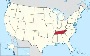
 Location within the U.S. state of Tennessee | |
 Tennessee's location within the U.S. | |
| Coordinates: 36°06′N 82°26′W | |
| Country | |
| State | |
| Founded | March 23, 1875 |
| Named for | Cherokee word for "fog-draped" or "hazy"[1] |
| Seat | Erwin |
| Largest town | Erwin |
| Area | |
| • Total | 186 sq mi (480 km2) |
| • Land | 186 sq mi (480 km2) |
| • Water | 0.3 sq mi (0.8 km2) 0.2% |
| Population (2020) | |
| • Total | 17,928 |
| • Density | 98/sq mi (38/km2) |
| Time zone | UTC−5 (Eastern) |
| • Summer (DST) | UTC−4 (EDT) |
| Congressional district | 1st |
| Website | www |
History
This area was long inhabited by indigenous peoples, including the historic Cherokee who encountered European and English traders and settlers. The mountainous terrain made it less attractive to subsistence farmers.
Unicoi County was created in 1875 from portions of Washington and Carter counties. Its first European-American settlers had arrived more than a century earlier but the population had been small.[1] The county remained predominantly agrarian until the railroads were constructed in the area in the 1880s.[1]
During the 1910s, the Clinchfield Railroad established a pottery in Erwin, which eventually incorporated under the name, "Southern Potteries." This company produced a popular brand of dishware, commonly called Blue Ridge China, which featured hand-painted underglaze designs. While the company folded in the 1950s, Blue Ridge dishes remain popular with antique collectors.[1]
In 1916, a circus elephant, Mary, was hanged on September 13, 1916, in Erwin for killing her trainer in nearby Kingsport. The elephant was hanged by the neck from a railcar-mounted industrial derrick between four o'clock and five o'clock that afternoon. The first attempt resulted in a snapped chain, causing Mary to fall and break her hip as dozens of children fled in terror. The severely wounded elephant died during a second attempt and was buried beside the tracks. The hanging was the subject of a book, The Day They Hung the Elephant (1992), by Charles Edwin Price.
Pronunciation
Hear it spoken (Voice of Unicoi County Mayor Greg Lynch, 2010)
Geography

According to the U.S. Census Bureau, the county has a total area of 186 square miles (480 km2), of which 186 square miles (480 km2) is land and 0.3 square miles (0.78 km2) (0.2%) is water.[4] It is the fifth-smallest county in Tennessee by total area. The Nolichucky River, which enters Unicoi County from North Carolina, is the county's primary drainage.
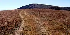
Unicoi County is situated entirely within the Blue Ridge Mountains,[5] specifically the Bald Mountains (south of the Nolichucky) and the Unaka Range (north of the Nolichucky). Big Bald, which at 5,516 feet (1,681 m) is the highest mountain in the Balds, is also Unicoi County's high point.[6] Traversed by the Appalachian Trail, the mountain is topped by a grassy bald, allowing a 360-degree view of the surrounding mountains.
Adjacent counties
- Washington County (north)
- Carter County (northeast)
- Mitchell County, North Carolina (east)
- Yancey County, North Carolina (south)
- Madison County, North Carolina (southwest)
- Greene County (west)
National protected areas
- Appalachian Trail (part)
- Cherokee National Forest (part)
State protected areas
Demographics
| Census | Pop. | Note | %± |
|---|---|---|---|
| 1880 | 3,645 | — | |
| 1890 | 4,619 | 26.7% | |
| 1900 | 5,851 | 26.7% | |
| 1910 | 7,201 | 23.1% | |
| 1920 | 10,120 | 40.5% | |
| 1930 | 12,678 | 25.3% | |
| 1940 | 14,128 | 11.4% | |
| 1950 | 15,886 | 12.4% | |
| 1960 | 15,082 | −5.1% | |
| 1970 | 15,254 | 1.1% | |
| 1980 | 16,362 | 7.3% | |
| 1990 | 16,549 | 1.1% | |
| 2000 | 17,667 | 6.8% | |
| 2010 | 18,313 | 3.7% | |
| 2020 | 17,928 | −2.1% | |
| U.S. Decennial Census[7] 1790-1960[8] 1900-1990[9] 1990-2000[10] 2010-2014[11] | |||

2020 census
| Race | Number | Percentage |
|---|---|---|
| White (non-Hispanic) | 16,175 | 90.22% |
| Black or African American (non-Hispanic) | 44 | 0.25% |
| Native American | 38 | 0.21% |
| Asian | 37 | 0.21% |
| Other/Mixed | 527 | 2.94% |
| Hispanic or Latino | 1,107 | 6.17% |
As of the 2020 United States census, there were 17,928 people, 7,658 households, and 4,953 families residing in the county.
2000 census
As of the census[14] of 2000, there were 17,667 people, 7,516 households, and 5,223 families residing in the county. The population density was 95 people per square mile (37 people/km2). There were 8,214 housing units at an average density of 44 units per square mile (17/km2). The racial makeup of the county was 97.96% White, 0.07% Black or African American, 0.25% Native American, 0.08% Asian, 0.03% Pacific Islander, 0.95% from other races, and 0.66% from two or more races. 1.94% of the population were Hispanic or Latino of any race.
There were 7,516 households, out of which 26.60% had children under the age of 18 living with them, 56.40% were married couples living together, 9.50% had a female householder with no husband present, and 30.50% were non-families. 27.50% of all households were made up of individuals, and 13.40% had someone living alone who was 65 years of age or older. The average household size was 2.31 and the average family size was 2.80.
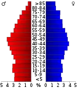
In the county, the population was spread out, with 20.50% under the age of 18, 7.50% from 18 to 24, 27.50% from 25 to 44, 26.50% from 45 to 64, and 18.10% who were 65 years of age or older. The median age was 42 years. For every 100 females, there were 95.10 males. For every 100 females age 18 and over, there were 91.60 males.
The median income for a household in the county was $29,863, and the median income for a family was $36,871. Males had a median income of $30,206 versus $20,379 for females. The per capita income for the county was $15,612. About 8.70% of families and 13.10% of the population were below the poverty line, including 17.70% of those under age 18 and 13.50% of those age 65 or over.
Communities
Census-designated place
Unincorporated communities
- Bumpus Cove (partial)
- Clearbranch
- Flag Pond
- Limestone Cove
- Shallowford
Politics
Voters of Unicoi County, like most of eastern Tennessee, have been strongly affiliated with the Republican Party since before the Civil War, when it was a Unionist enclave. Since its founding, it has supported the Republican presidential candidate in all but one election (1912, when it backed Theodore Roosevelt's Progressive Party campaign).
At the state level, Unicoi County has historically been slightly more receptive to Democratic candidates, generally when they win by landslides. It often supported Democratic candidates for governor in the Solid South era, when white conservatives largely were affiliated as Democrats. More recently, it backed Democrat Ned McWherter in the 1986 and 1990 gubernatorial elections and Phil Bredesen in 2006, when he won every county in the state.
| Year | Republican | Democratic | Third party | |||
|---|---|---|---|---|---|---|
| No. | % | No. | % | No. | % | |
| 2020 | 6,599 | 79.44% | 1,615 | 19.44% | 93 | 1.12% |
| 2016 | 5,671 | 78.82% | 1,262 | 17.54% | 262 | 3.64% |
| 2012 | 5,032 | 71.01% | 1,913 | 27.00% | 141 | 1.99% |
| 2008 | 5,011 | 69.38% | 2,107 | 29.17% | 105 | 1.45% |
| 2004 | 5,030 | 67.40% | 2,374 | 31.81% | 59 | 0.79% |
| 2000 | 3,780 | 58.80% | 2,566 | 39.91% | 83 | 1.29% |
| 1996 | 3,122 | 54.25% | 2,131 | 37.03% | 502 | 8.72% |
| 1992 | 3,344 | 51.87% | 2,375 | 36.84% | 728 | 11.29% |
| 1988 | 3,664 | 66.79% | 1,794 | 32.70% | 28 | 0.51% |
| 1984 | 4,249 | 71.07% | 1,696 | 28.37% | 34 | 0.57% |
| 1980 | 3,828 | 65.50% | 1,880 | 32.17% | 136 | 2.33% |
| 1976 | 3,211 | 55.53% | 2,526 | 43.69% | 45 | 0.78% |
| 1972 | 3,877 | 81.35% | 822 | 17.25% | 67 | 1.41% |
| 1968 | 3,327 | 65.49% | 910 | 17.91% | 843 | 16.59% |
| 1964 | 2,731 | 57.73% | 2,000 | 42.27% | 0 | 0.00% |
| 1960 | 4,004 | 75.04% | 1,322 | 24.78% | 10 | 0.19% |
| 1956 | 3,978 | 77.71% | 1,111 | 21.70% | 30 | 0.59% |
| 1952 | 3,453 | 74.81% | 1,163 | 25.19% | 0 | 0.00% |
| 1948 | 1,927 | 67.35% | 844 | 29.50% | 90 | 3.15% |
| 1944 | 1,992 | 71.89% | 779 | 28.11% | 0 | 0.00% |
| 1940 | 1,863 | 64.67% | 985 | 34.19% | 33 | 1.15% |
| 1936 | 1,850 | 67.13% | 879 | 31.89% | 27 | 0.98% |
| 1932 | 1,716 | 66.87% | 850 | 33.13% | 0 | 0.00% |
| 1928 | 2,043 | 84.25% | 375 | 15.46% | 7 | 0.29% |
| 1924 | 1,381 | 72.68% | 381 | 20.05% | 138 | 7.26% |
| 1920 | 2,584 | 82.42% | 547 | 17.45% | 4 | 0.13% |
| 1916 | 961 | 80.96% | 226 | 19.04% | 0 | 0.00% |
| 1912 | 280 | 22.84% | 170 | 13.87% | 776 | 63.30% |
References
- Hilda Britt Padgett, "Unicoi County," Tennessee Encyclopedia of History and Culture. Retrieved: 19 April 2013.
- "Census - Geography Profile: Unicoi County, Tennessee". United States Census Bureau. Retrieved January 7, 2023.
- "Find a County". National Association of Counties. Retrieved June 7, 2011.
- "2010 Census Gazetteer Files". United States Census Bureau. August 22, 2012. Retrieved April 14, 2015.
- Tennessee Department of Environment and Conservation, et al., "Ambient Air Monitoring Plan," Environmental Protection Agency website, 1 July 2010. Accessed: 18 March 2015.
- Tom Dunigan, Tennessee County High Points, Tennessee Landforms. Retrieved: 7 November 2013.
- "U.S. Decennial Census". United States Census Bureau. Retrieved April 14, 2015.
- "Historical Census Browser". University of Virginia Library. Retrieved April 14, 2015.
- Forstall, Richard L., ed. (March 27, 1995). "Population of Counties by Decennial Census: 1900 to 1990". United States Census Bureau. Retrieved April 14, 2015.
- "Census 2000 PHC-T-4. Ranking Tables for Counties: 1990 and 2000" (PDF). United States Census Bureau. April 2, 2001. Archived (PDF) from the original on October 9, 2022. Retrieved April 14, 2015.
- "State & County QuickFacts". United States Census Bureau. Retrieved December 7, 2013.
- Based on 2000 census data
- "Explore Census Data". data.census.gov. Retrieved December 26, 2021.
- "U.S. Census website". United States Census Bureau. Retrieved May 14, 2011.
- Leip, David. "Dave Leip's Atlas of U.S. Presidential Elections". uselectionatlas.org. Retrieved March 12, 2018.