Interstate 57
Interstate 57 (I-57) is a north–south Interstate Highway in Missouri and Illinois that parallels the old Illinois Central Railroad for much of its route. It runs from Sikeston, Missouri, at I-55 to Chicago, Illinois, at I-94. I-57 essentially serves as a shortcut route for travelers headed between the South (Memphis, New Orleans, etc.) and Chicago, bypassing St. Louis, Missouri and Springfield, Illinois. Between the junction of I-55 and I-57 in Sikeston and the junction of I-55 and I-90/I-94 in Chicago, I-55 travels for 436 miles (702 km), while the combination of I-57 and I-94 is only 396 miles (637 km) long between the same two points. In fact, both the control cities on the overhead signs and the destination mileage signs reference Memphis along southbound I-57, even as far north as its northern origin at I-94 in Chicago.[2] Likewise, at its southern end, Chicago is the control city listed for I-57 on signs on northbound I-55 south of Sikeston, even though I-55 also goes to Chicago.[3] A southward extension of I-57 from its current southern terminus to Little Rock, Arkansas is currently in various stages of development.
Interstate 57 | |||||||
|---|---|---|---|---|---|---|---|
I-57 highlighted in red | |||||||
| Route information | |||||||
| Maintained by MoDOT and IDOT | |||||||
| Length | 386.12 mi[1] (621.40 km) | ||||||
| Existed | 1959–present | ||||||
| NHS | Entire route | ||||||
| Major junctions | |||||||
| South end | |||||||
| |||||||
| North end | |||||||
| Location | |||||||
| Country | United States | ||||||
| States | Missouri, Illinois | ||||||
| Counties | MO: Scott, Mississippi IL: Alexander, Pulaski, Union, Johnson, Williamson, Franklin, Jefferson, Marion, Fayette, Clay, Effingham, Shelby, Cumberland, Coles, Douglas, Champaign, Ford, Iroquois, Kankakee, Will, Cook | ||||||
| Highway system | |||||||
| |||||||

As of 2023, I-57 has no spur routes nor are any planned for the near future.[4] At a length of just over 386 miles (621 km), it is the second-longest two-digit Interstate Highway without an auxiliary route, behind I-49. I-57 has one business loop in Charleston, Missouri.
Route description
Missouri

In the state of Missouri, I-57 runs northbound from Sikeston to the Cairo I-57 Bridge over the Mississippi River north of Cairo, Illinois.
After ending southbound at I-55, the highway continues as U.S. Route 60 (US 60), which meets US 67 at Poplar Bluff, and, from there, US 67 goes south to Little Rock, Arkansas.
From the start of I-57 northbound, the US 60 concurrency goes about 12 miles (19 km).
Illinois
Interstate 57 is the longest interstate highway in the state of Illinois spanning 396 miles long with Chicago being the main city along its northern route and Memphis being the southern main city along its southern route. Interstate 57 starts at a Cloverleaf interchange in Sikeston, Missouri. As it heads north, it has one business route which lies entirelyrely with of Charleston, MO. Interstate 57 then enters Illinois across the Mississippi River into Cairo, Illinois. It passes through Mounds, Illinois, Ullin, Illinois, and then it makes an interchange with U.S. Route 51, making U.S 51 depart from its temporary concurrency with the interstate. Interstate 57 then continues north and has a unknown type of interchange with Interstate 24 towards Nashville, Tennessee. It then continues to head towards Marion, IL, West Frankfort, Illinois, Benton, Illinois, Whittington, Illinois, Ina, Illinois, and then heads into Mount Vernon, Illinois. In Mt.Vernon, Interstate 57 has a short concurrency with Interstate 64 while making two diamond interchanges with the city's streets. Interstate 64 then leaves Interstate 57 and continues its western route towards St. Louis, while Interstate 57 continues towards Effingham, Illinois. In Effingham, Interstate 70 joins Interstate 57 and makes interchanges with the city's streets once again. Interstate 70 then departs from Interstate 57 and continues east towards Terre Haute, Indiana and Indianapolis. As for Interstate 57, it continues and heads towards Mattoon, Illinois where it has a cloverleaf interchange with U.S. Route 45 and then heads towards Champaign, Illinois where it meets the terminus of Interstate 72 in a cloverleaf interchange. It then travels for another 2 miles, and then meets up with a soon to be changed from a cloverleaf interchange to a semi-directional interchange with Interstate 74 going east towards Indianapolis (again) and west towards Bloomington, Illinois. The interstate then heads towards Kankakee, Illinois and then into Cook County, Illinois where it meets its own terminus with Interstate 94 ending in Chicago.
History
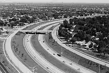
The oldest segment of I-57 is a 6.2-mile (10.0 km) strip running east of Bradley to Kankakee labeled on the 1959 Illinois state highway map.[5] Two years later, a 30-mile (48 km) stretch of I-57 from Dongola north to Marion opened on September 26, 1961.[6] Another portion between the IL 121/US 45 exit and the Watson–Mason exit was completed and opened prior to July 1965, linking I-57 to I-70 and running in tandem with I-70 for several miles, with access to Indianapolis, Indiana, to the east and St. Louis, Missouri, to the west. A 21.5-mile (34.6 km) section of I-57 in Jefferson County from Bonnie (using a temporary road that is still partially visible from the northbound lanes) to IL 161 later opened on December 9, 1969.[7] The portion of I-57 in Chicago (known as the Dan Ryan West Leg Extension) was constructed and opened in segments between 1963 and 1970. It remains the most recent Interstate Highway to be established within the city.[6] The final section of I-57 in Illinois opened in December 1971 at Paxton.[8]
The portion of I-43 from Milwaukee to Green Bay was originally numbered as Interstate 57.[9] The number was changed due to the existence of I-57 in Illinois.[10]
I-57 was widened to six lanes in Effingham from 2011 until 2016.[11]
For many years, an interchange at the junction of I-57 with I-294 did not exist. It was one of the few places in the US where Interstates cross but have no interchange. The Illinois Department of Transportation (IDOT) and Illinois State Toll Highway Authority (ISTHA) opened Phase 1 of a new interchange in 2014, providing access from I-57 north to I-294 north and from I-294 south to I-57 south.[12] Phase 2 which completed the remaining movements except for northbound I-57 to southbound I-294 and northbound I-294 to southbound I-57 was opened to traffic on September 11, 2022.[13]
Future
I-57 is slated to eventually be extended west along US 60 to Poplar Bluff, Missouri, and then south along the US 67 corridor to North Little Rock, Arkansas, ending at I-40.[14] The extension is listed under High Priority Corridor 89, the I-57 Corridor Extension.[15] In April 2016, a provision designating US 67 from North Little Rock to Walnut Ridge, Arkansas, as "Future I-57" was added into the federal fiscal year 2017 Transportation, Housing and Urban Development funding bill and officially became law in 2017.[16]
Missouri has already converted 62 miles (100 km) of the US 60/US 67 corridor between Sikeston and Route 158 near Harviell to a mixture of freeway and expressway segments. All at-grade crossings along the corridor would have to be eliminated before the Interstate designation could be applied.[17] A new freeway segment from Route 158 to just south of Neelyville near County Road 274 (about two miles (3.2 km) north of the Arkansas border) has been announced as part of a cost share program and is in the planning stages.[18][19] In August 2022, redesign of the US 67 and US 160/Route 158 interchange began. The interchange will be transformed to contain roundabouts.[20][21][22] The work is slated to be completed by November 2023.[23]
In Arkansas, 118 miles (190 km) of Interstate-grade US 67 runs from I-40 to US 412 in Walnut Ridge, leaving a segment of approximately 40 miles (64 km) of new Interstate-grade highway along US 67 that still would need to be built in northeastern Arkansas.[24] On February 23, 2018, Arkansas state officials unveiled a "Future I-57" sign to be posted along the corridor of US 67.[25] A route for I-57 from Walnut Ridge to the Missouri state line was chosen in 2022. The route shows it passing near levees. The route is not finalized, and the I-57 route may be adjusted to not have any impact on the levees.[26] ARDOT announced in September 2023 that work to extend Future I-57 in Clay County would begin in late 2024 or early 2025 depending on when contracts are let along with completion of the final design process.[27] The first section will be between the US 67 interchanges at Walnut Ridge and Corning while the second section (which will begin construction starting in 2026) will extend the first section northward to the Missouri state line.[28]
Exit list
| State | County | Location | mi[29][30] | km | Exit | Destinations | Notes | |
|---|---|---|---|---|---|---|---|---|
| Missouri | Scott | Sikeston | 0.000 | 0.000 | Continuation beyond I-55; southern end of US 60 concurrency; future I-57 south | |||
| 0.000– 0.538 | 0.000– 0.866 | 1 | Current southern terminus; signed as exits 1A (south) and 1B (north); I-55 exit 66 | |||||
| Mississippi | Long Prairie Township | 4.916 | 7.912 | 4 | ||||
| Charleston | 10.745 | 17.292 | 10 | |||||
| 13.027 | 20.965 | 12 | Northern end of US 60 concurrency | |||||
| Mississippi River | 22.328 0.00 | 35.933 0.00 | Interstate 57 Bridge Missouri–Illinois state line | |||||
| Illinois | Alexander | Cairo | 1.4 | 2.3 | 1 | Southern end of US 51 concurrency | ||
| Pulaski | Mounds | 7.6 | 12.2 | 8 | Mounds Road | |||
| Ullin | 17.7 | 28.5 | 18 | Ullin | ||||
| Union | Dongola | 24.4 | 39.3 | 24 | Dongola Road | |||
| 25.0 | 40.2 | 25 | Northern end of US 51 concurrency; northbound exit and southbound entrance | |||||
| Anna | 30.0 | 48.3 | 30 | |||||
| Buncombe | 36.3 | 58.4 | 36 | Lick Creek Road | ||||
| Johnson | Goreville | 39.7 | 63.9 | 40 | Goreville Road | |||
| Williamson | Southern Precinct | 43.9 | 70.7 | 44 | Western terminus of I-24 | |||
| 45.2 | 72.7 | 45 | ||||||
| Marion | 52.9 | 85.1 | 53 | Main Street – Marion | Former IL 13 | |||
| 53.6 | 86.3 | 54 | The Hill Avenue | Split into exits 54A (IL 13) and 54B (The Hill Ave.) northbound | ||||
| Johnston City | 58.9 | 94.8 | 59 | Johnston City, Herrin | ||||
| Franklin | West Frankfort | 64.6 | 104.0 | 65 | ||||
| West City | 71.6 | 115.2 | 71 | To IL 34 | ||||
| Ewing Township | 77.5 | 124.7 | 77 | |||||
| Jefferson | Ina | 82.6 | 132.9 | 83 | Ina | |||
| Dodds Township | 91.5 | 147.3 | 92 | Southern end of I-64 concurrency; I-64 exit 78 westbound | ||||
| Mt. Vernon | 93.7 | 150.8 | 94 | Veterans Memorial Drive | ||||
| 94.7 | 152.4 | 95 | ||||||
| 96.2 | 154.8 | 96 | Northern end of I-64 concurrency; I-64 exit 73 eastbound | |||||
| Dix | 103.5 | 166.6 | 103 | Dix | ||||
| Marion | Raccoon Township | 109.2 | 175.7 | 109 | ||||
| Salem | 116.4 | 187.3 | 116 | |||||
| Kinmundy Township | 127.2 | 204.7 | 127 | Patoka, Kinmundy | ||||
| Fayette | Farina | 135.4 | 217.9 | 135 | ||||
| Clay |
No major junctions | |||||||
| Effingham | Mason Township | 144.7 | 232.9 | 145 | Edgewood | |||
| 150.7 | 242.5 | 151 | Watson, Mason | |||||
| Summit Township | 157.3 | 253.1 | 157 | Southern end of I-70 concurrency; exit 92 eastbound | ||||
| Effingham | 159.4 | 256.5 | 159 | Fayette Avenue | ||||
| 160.5 | 258.3 | 160 | Access to Lake Shelbyville and Convention Center | |||||
| 162.2 | 261.0 | 162 | Access to Lake Land College and Kuthe Center | |||||
| Teutopolis Township | 163.4 | 263.0 | 163 | Northern end of I-70 concurrency; exit 98 westbound | ||||
| Shelby |
No major junctions | |||||||
| Cumberland | Neoga Township | 177.0 | 284.9 | 177 | ||||
| Coles | Mattoon | 184.4 | 296.8 | 184 | ||||
| 189.6 | 305.1 | 190 | Signed as exits 190A (east) and 190B (west) Access to Coles County Airport and Eastern Illinois University | |||||
| 192.4 | 309.6 | 192 | ||||||
| Douglas | Arcola | 203.6 | 327.7 | 203 | ||||
| Tuscola | 211.7 | 340.7 | 212 | |||||
| Champaign | Pesotum | 219.9 | 353.9 | 220 | ||||
| Tolono Township | 228.6 | 367.9 | 229 | Monticello, Savoy, Tolono | Access to Willard Airport | |||
| Champaign Township | 231.7 | 372.9 | 232 | Curtis Road | ||||
| Champaign | 235.2 | 378.5 | 235 | Signed as 235A (University Ave.) and 235B (I-72); I-72 exit 182 | ||||
| 237.4 | 382.1 | 237 | Signed as exits 237A (east) and 237B (west); I-74 exit 179 | |||||
| 238.4 | 383.7 | 238 | Olympian Drive | |||||
| Hensley Township | 240.5 | 387.0 | 240 | Market Street | ||||
| Rantoul | 250.2 | 402.7 | 250 | |||||
| Ford | Paxton | 260.9 | 419.9 | 261 | ||||
| Iroquois | Artesia Township | 271.9 | 437.6 | 272 | Buckley, Roberts | Roberts signed northbound only | ||
| Onarga Township | 279.9 | 450.5 | 280 | Roberts signed southbound only | ||||
| Gilman | 282.9 | 455.3 | 283 | |||||
| Ashkum Township | 292.7 | 471.1 | 293 | |||||
| Clifton | 296.5 | 477.2 | 297 | Clifton | ||||
| Chebanse Township | 301.6 | 485.4 | 302 | Chebanse | ||||
| Kankakee | Kankakee | 307.5 | 494.9 | 308 | ||||
| 311.6 | 501.5 | 312 | ||||||
| 315.3 | 507.4 | 315 | ||||||
| Bourbonnais | 318.4 | 512.4 | 318 | Bourbonnais Parkway | Opened November 2, 2018[31] | |||
| Manteno | 321.6 | 517.6 | 322 | Manteno | ||||
| Will | Peotone Township | 327.1 | 526.4 | 327 | Wilmington, Peotone | |||
| Monee | 335.1 | 539.3 | 335 | Manhattan, Monee | ||||
| University Park | 337.1 | 542.5 | 337 | Stuenkel Road / University Parkway | Access to Governors State University; interchange opened on October 30, 2015 | |||
| Cook | Richton Park | 339.0 | 545.6 | 339 | Sauk Trail | |||
| Matteson | 340.69 | 548.29 | 340 | Signed as exits 340A (east) and 340B (west) southbound | ||||
| 342.21 | 550.73 | 342 | Vollmer Road | Signed as exits 342A (east) and 342B (west) southbound | ||||
| Bremen Township | 344.67– 344.86 | 554.69– 555.00 | 345 | Signed as exits 345A (east) and 345B (west); I-80 exit 151 | ||||
| 346.62 | 557.83 | 346 | Signed as exits 346A (east) and 346B (west to IL 50) | |||||
| Markham | 347.90 | 559.89 | 348 | Signed as exits 348A (east) and 348B (west) | ||||
| 349.62 | 562.66 | 349 | I-Pass or pay online; signed as exits 349A (north) and 349 (south) southbound; no northbound exit to I-294 south; no southbound entrance from I-294 north; I-294 exit 7 | |||||
| Posen | 350.15 | 563.51 | 350 | |||||
| Calumet Park | 353.25 | 568.50 | 353 | 127th Street / Burr Oak Avenue | ||||
| Calumet Park–Chicago line | 354.25 | 570.11 | 354 | 119th Street | ||||
| Chicago | 355.27 | 571.75 | 355 | 111th Street / Monterey Avenue | ||||
| 357.32 | 575.05 | 357 | Northern terminus of IL 1 | |||||
| 358.47 | 576.90 | — | Northbound exit and southbound entrance; I-94 exit 63 | |||||
| 358.57 | 577.06 | 358 | Wentworth Avenue | Southbound exit only | ||||
| 359.12 | 577.95 | Northern terminus; I-94 exit 63 | ||||||
| 1.000 mi = 1.609 km; 1.000 km = 0.621 mi | ||||||||
Charleston business loop
Interstate 57 Business | |
|---|---|
| Location | Charleston, Missouri |
| Length | 2.94 mi (4.73 km) |
Interstate 57 Business (I-57 Bus.) in Charleston begins at I-57 exit 10. From this diamond interchange, it runs north in a concurrency with Route 105 along South Main Street into the city center. It then turns east onto Marshall Street, which also carries US 62 and Route 77. The business route ends at I-57 exit 12, with US 62 and Route 77 continuing to the east.
See also
References
- Federal Highway Administration (October 31, 2002). "Table 1: Main Routes of the Dwight D. Eisenhower National System of Interstate and Defense Highways as of October 31, 2002". Federal Highway Administration. Retrieved July 13, 2006.
- American Association of State Highway and Transportation Officials. "Interstate Control Cities". American Association of State Highway and Transportation Officials. Retrieved July 10, 2021.
- Missouri Department of Transportation (n.d.). Exit 64A sign (Highway guide sign). Sikeston: Missouri Department of Transportation. Retrieved April 4, 2012.
- Federal Highway Administration (December 31, 2018). "Table 2: Auxiliary Routes of the Dwight D. Eisenhower National System Of Interstate and Defense Highways as of December 31, 2018". Federal Highway Administration. Retrieved July 10, 2021.
- Illinois Division of Highways; H.M. Gousha (1959). Illinois Official Highway Map (Map). [1:790,00]. Springfield: Illinois Division of Highways – via Illinois Digital Archives.
- "Interstate 57". Interstate Guide. Retrieved May 17, 2019.
- Mt. Vernon Register-News. December 9, 1969.
{{cite news}}: Missing or empty|title=(help) - Southern Illinoisan. December 29, 1971.
{{cite news}}: Missing or empty|title=(help) - Fond du Lac Reporter. March 9, 1972.
{{cite news}}: Missing or empty|title=(help) - The Journal Times. Racine, WI. December 10, 1974.
{{cite news}}: Missing or empty|title=(help) - "I-57/I-70 Rehabilitation". Lochmueller Group. Archived from the original on March 24, 2016. Retrieved March 14, 2022.
- "Interchange connecting I-57, I-294 opens". ABC7 Chicago. October 25, 2014. Retrieved March 14, 2022.
- "I-294/I-57 Interchange Project - Phase 2". Illinois State Toll Highway Authority. Retrieved December 3, 2022.
- Miller, Bob (February 27, 2023). "Extension of I-57 to impact national traffic, Poplar Bluff and Arkansas economies". Southeast Missourian. Retrieved May 18, 2023.
- "Statutory Listing of Corridor Descriptions - High Priority Corridors - National Highway System - Planning - FHWA". www.fhwa.dot.gov. Retrieved January 4, 2022.
- "Arkansas Highway to Receive 'Future I-57' Designation". Times Record. Arkansas News Bureau. Retrieved June 14, 2017.
- Heuring, Leonna (August 1, 2010). "MoDOT Celebrates Completion of US 60 Four-Lane Project with Caravan". The Southeast Missourian. Cape Girardeau, Missouri. Retrieved April 26, 2016.
- Ruch, Amber (March 3, 2020). "Gov. Parson visits transportation cost-share project in Poplar Bluff, Mo". KFVS-TV. Retrieved March 14, 2022.
- "U.S. 67 (Future I-57) in Butler County". Retrieved April 26, 2020.
- Newsdesk, Region 8 (August 11, 2022). "First phase of Future I-57 project slated to begin". Jonesboro, Arkansas: KAIT-TV. Retrieved October 9, 2022.
- Ruch, Amber (June 14, 2023). "1st phase of U.S. 67/Future I-57 project in Butler Co. continues with intersection changes". www.kfvs12.com. Retrieved July 10, 2023.
- "U.S. 67 (Future I-57) Corridor Upgrades in Butler County | Missouri Department of Transportation". www.modot.org. Retrieved July 10, 2023.
- "First phase of Future I-57 project slated to begin". KAIT 8. August 11, 2022. Retrieved October 24, 2023.
- Reaves, Jonathan (June 2017). "Arkansas 'has a lot of work to do' to bring 'Future I-57' to Missouri line". KASU-TV. Retrieved June 14, 2017.
- Pettit, Emma (February 23, 2018). "Corridor stretching from North Little Rock to northeast Arkansas recognized as future interstate". Arkansas Democrat-Gazette. Retrieved February 23, 2018.
- Savage, Hayden (December 2, 2022). "Future I-57 potentially covering levee in Randolph County". Jonesboro, Arkansas: KAIT-TV. Retrieved February 2, 2023.
- "I-57 route identified". Jonesboro Sun. October 25, 2023. Retrieved October 26, 2023.
- Savage, Hayden (September 21, 2023). "Work expected to begin on "Future I-57″ in 2024". KAIT 8. Retrieved October 24, 2023.
- Missouri Department of Transportation (November 14, 2012). MoDOT HPMAPS (Map). Missouri Department of Transportation. Retrieved November 14, 2012.
- Google (July 10, 2014). "Map of Interstate 57 in Illinois" (Map). Google Maps. Google. Retrieved July 10, 2014.
- Dykstra, John (November 3, 2018). "I-57 interchange at Bourbonnais Parkway finally opens". The Daily Journal. Kankakee, Illinois. Retrieved November 5, 2018.
External links
| Signed | |
|---|---|
| Unsigned | |
| Lists | |
| Other | |
Routes in italics are no longer a part of the system. Major Interstates are highlighted. | |