Isabel, Leyte
Isabel (IPA: [ʔɪsɐ'bɛl]), officially the Municipality of Isabel (Cebuano: Lungsod sa Isabel; Waray: Bungto han Isabel; Tagalog: Bayan ng Isabel), is a 1st class municipality in the province of Leyte, Philippines. According to the 2020 census, it has a population of 46,781 people.[3]
Isabel
Quiot | |
|---|---|
| Municipality of Isabel | |
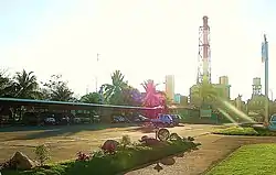 Philippine Associated Smelting and Refining Corp. | |
 Flag | |
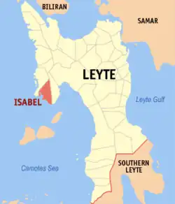 Map of Leyte with Isabel highlighted | |
OpenStreetMap | |
.svg.png.webp) Isabel Location within the Philippines | |
| Coordinates: 10°56′N 124°26′E | |
| Country | Philippines |
| Region | Eastern Visayas |
| Province | Leyte |
| District | 4th district |
| Founded | 15 January 1948 |
| Barangay | 24 (see Barangays) |
| Government | |
| • Type | Sangguniang Bayan |
| • Mayor | Atty. Edgardo Cordeño |
| • Vice Mayor | Adam Fuentes |
| • Representative | Richard Gomez |
| • Councilors | List |
| • Electorate | 34,460 voters (2022) |
| Area | |
| • Total | 64.01 km2 (24.71 sq mi) |
| Elevation | 30 m (100 ft) |
| Highest elevation | 573 m (1,880 ft) |
| Lowest elevation | 0 m (0 ft) |
| Population (2020 census)[3] | |
| • Total | 46,781 |
| • Density | 730/km2 (1,900/sq mi) |
| • Households | 11,758 |
| Economy | |
| • Income class | 1st municipal income class |
| • Poverty incidence | 17.83 |
| • Revenue | ₱ 190.8 million (2020) |
| • Assets | ₱ 707.7 million (2020) |
| • Expenditure | ₱ 209.2 million (2020) |
| • Liabilities | ₱ 437.1 million (2020) |
| Service provider | |
| • Electricity | Leyte 5 Electric Cooperative (LEYECO 5) |
| Time zone | UTC+8 (PST) |
| ZIP code | 6539 |
| PSGC | |
| IDD : area code | +63 (0)53 |
| Native languages | Cebuano Tagalog |
History
The town was formally established and created by carving out the villages of Quiot, Santa Cruz, Libertad, Matlang, Tolingon, Bantigue, Apale and Honan from the town of Merida, by the passage of Republic Act No. 191.[5][6]
Geography
Isabel is bounded to the east by the municipality of Merida and to the north by the municipality of Palompon. Nearest landfall south is Ponson Island (Camotes) at about 7.2 kilometres (4.5 mi; 3.9 nmi). Nearest landfall west is coastal Tabogon, Cebu at about 50 kilometres (31 mi; 27 nmi).[7]
Climate
| Climate data for Isabel, Leyte | |||||||||||||
|---|---|---|---|---|---|---|---|---|---|---|---|---|---|
| Month | Jan | Feb | Mar | Apr | May | Jun | Jul | Aug | Sep | Oct | Nov | Dec | Year |
| Average high °C (°F) | 28 (82) |
29 (84) |
29 (84) |
30 (86) |
30 (86) |
30 (86) |
29 (84) |
29 (84) |
29 (84) |
29 (84) |
29 (84) |
29 (84) |
29 (84) |
| Average low °C (°F) | 22 (72) |
22 (72) |
22 (72) |
23 (73) |
25 (77) |
25 (77) |
25 (77) |
25 (77) |
25 (77) |
24 (75) |
24 (75) |
23 (73) |
24 (75) |
| Average precipitation mm (inches) | 78 (3.1) |
57 (2.2) |
84 (3.3) |
79 (3.1) |
118 (4.6) |
181 (7.1) |
178 (7.0) |
169 (6.7) |
172 (6.8) |
180 (7.1) |
174 (6.9) |
128 (5.0) |
1,598 (62.9) |
| Average rainy days | 16.7 | 13.8 | 17.3 | 18.5 | 23.2 | 26.5 | 27.1 | 26.0 | 26.4 | 27.5 | 24.6 | 21.0 | 268.6 |
| Source: Meteoblue[9] | |||||||||||||
Demographics
|
| ||||||||||||||||||||||||||||||||||||||||||
| Source: Philippine Statistics Authority[10][11][12][13] | |||||||||||||||||||||||||||||||||||||||||||
In the 2020 census, the population of Isabel, Leyte, was 46,781 people,[3] with a density of 730 inhabitants per square kilometre or 1,900 inhabitants per square mile.
Economy
Leyte Industrial Development Estate (LIDE) is a 425 ha special economic zone in the industrial town of Isabel. It currently has 2 locators: PASAR (Philippine Associated Smelting & Refining Corporation) & PHILPHOS(Philippine Phosphate Fertilizer Corporation).
Education
| School |
|---|
| Visayas State University- Isabel Campus |
| LIDE Learning Center Inc. |
| Doane Baptist School of Isabel |
| Isabel National Comprehensive School |
| Isabel National Highschool |
| Holy Child Parish School of Isabel |
| Matlang National High School |
| Bilwang Elementary School |
| Matlang Elementary School |
References
- Municipality of Isabel | (DILG)
- "2015 Census of Population, Report No. 3 – Population, Land Area, and Population Density" (PDF). Philippine Statistics Authority. Quezon City, Philippines. August 2016. ISSN 0117-1453. Archived (PDF) from the original on May 25, 2021. Retrieved July 16, 2021.
- Census of Population (2020). "Region VIII (Eastern Visayas)". Total Population by Province, City, Municipality and Barangay. Philippine Statistics Authority. Retrieved 8 July 2021.
- "PSA Releases the 2018 Municipal and City Level Poverty Estimates". Philippine Statistics Authority. 15 December 2021. Retrieved 22 January 2022.
- Republic Act No. 191 (22 June 1947). AN ACT CREATING THE MUNICIPALITY OF ISABEL, PROVINCE OF LEYTE.
- Presidential Proclamation No. 49 (8 January 1948). FIXING THE DATE FOR THE INAUGURATION OF THE MUNICIPALITY OF ISABELA, PROVINCE OF LEYTE (PDF).
- "Isabel Leyte". mapsguidesandmore.com. Retrieved January 14, 2019.
- "Province:". PSGC Interactive. Quezon City, Philippines: Philippine Statistics Authority. Retrieved 12 November 2016.
- "Isabel: Average Temperatures and Rainfall". Meteoblue. Retrieved 9 February 2020.
- Census of Population (2015). "Region VIII (Eastern Visayas)". Total Population by Province, City, Municipality and Barangay. Philippine Statistics Authority. Retrieved 20 June 2016.
- Census of Population and Housing (2010). "Region VIII (Eastern Visayas)" (PDF). Total Population by Province, City, Municipality and Barangay. National Statistics Office. Retrieved 29 June 2016.
- Censuses of Population (1903–2007). "Region VIII (Eastern Visayas)". Table 1. Population Enumerated in Various Censuses by Province/Highly Urbanized City: 1903 to 2007. National Statistics Office.
- "Province of". Municipality Population Data. Local Water Utilities Administration Research Division. Retrieved 17 December 2016.
- "Poverty incidence (PI):". Philippine Statistics Authority. Retrieved December 28, 2020.
- "Estimation of Local Poverty in the Philippines" (PDF). Philippine Statistics Authority. 29 November 2005.
- "2003 City and Municipal Level Poverty Estimates" (PDF). Philippine Statistics Authority. 23 March 2009.
- "City and Municipal Level Poverty Estimates; 2006 and 2009" (PDF). Philippine Statistics Authority. 3 August 2012.
- "2012 Municipal and City Level Poverty Estimates" (PDF). Philippine Statistics Authority. 31 May 2016.
- "Municipal and City Level Small Area Poverty Estimates; 2009, 2012 and 2015". Philippine Statistics Authority. 10 July 2019.
- "PSA Releases the 2018 Municipal and City Level Poverty Estimates". Philippine Statistics Authority. 15 December 2021. Retrieved 22 January 2022.
External links
 Media related to Isabel, Leyte at Wikimedia Commons
- Philippine Standard Geographic Code
- Local Governance Performance Management System Archived 2012-05-30 at the Wayback Machine
Places adjacent to Isabel, Leyte | |
|---|---|
Tacloban (capital and largest city) | |
| Municipalities |
|
| Component city | |
| Independent component city |
|
| Highly urbanized city |
|