Jaisinghpur, Sultanpur
Jaisinghpur is a village and tehsil headquarters in Sultanpur district, Uttar Pradesh, India.[2] As of 2011, it has a population of 2,211 people, in 353 households.[2] It has 4 primary schools and one hospital.[2] It hosts a haat on Tuesdays and Saturdays mostly dealing in tat patti.[3] It serves as the headquarters of a nyaya panchayat which also includes 23 other villages.[4] It is also the seat of a community development block, which was inaugurated in 1953.[3]
Jaisinghpur | |
|---|---|
Village | |
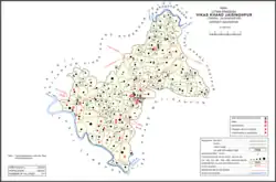 Map showing Jaisinghpur (#190) in Jaisinghpur CD block | |
 Jaisinghpur Location in Uttar Pradesh, India | |
| Coordinates: 26.286638°N 82.239521°E[1] | |
| Country | |
| State | Uttar Pradesh |
| Division | Ayodhya |
| District | Sultanpur |
| Area | |
| • Total | 0.719 km2 (0.278 sq mi) |
| Population (2011)[2] | |
| • Total | 2,211 |
| • Density | 3,100/km2 (8,000/sq mi) |
| Languages | |
| • Official | Hindi, Urdu |
| Time zone | UTC+5:30 (IST) |
History
At the turn of the 20th century, Jaisinghpur was described as a poor village, with narrow, twisting streets.[5] It formed part of the taluqdari estate of the Raja of Hasanpur, serving as a tehsil within the estate.[5] It had a small bazar, where a small sugar refining industry took place, but at that time the sugar refiners were struggling because of competition from beet sugar.[5] Jaisinghpur also had a police station and an upper primary school which was not attended by many students.[5] It was connected by a minor rail line to Sultanpur in one direction and Dostpur in the other.[5] As of 1901, Jaisinghpur had a population of 909.[5]
The 1951 census recorded Jaisinghpur (as "Jaisinghpur Kalan") as comprising 2 hamlets, with a total population of 892 people (482 male and 410 female), in 192 households and 180 physical houses.[6] The area of the village was given as 178 acres.[6] 55 residents were literate, all male.[6] The village was listed as belonging to the pargana of Baraunsa and the thana of Jaisinghpur.[6]
The 1961 census recorded Jaisinghpur (as "Jaisinghpur Kalan") as comprising 2 hamlets, with a total population of 1,001 people (524 male and 477 female), in 238 households and 215 physical houses.[3] The area of the village was given as 183 acres and it had a medical practitioner, maternity and child welfare centre, and post office at that point.[3] Its police force consisted of 2 sub-inspectors, 1 head constable, and 14 constables.[3] Average attendance of the twice-weekly haat was about 150 people.[3]
The 1981 census recorded Jaisinghpur as having a population of 1,360 people, in 252 households, and having an area of 72.04 hectares.[7] The main staple foods were listed as wheat and rice.[7]
The 1991 census recorded Jaisinghpur as having a total population of 1,610 people (838 male and 772 female), in 235 households and 234 physical houses.[4] The area of the village was listed as 72.04 hectares.[4] Members of the 0-6 age group numbered 290, or 18% of the total; this group was 46% male (132) and 54% female (158).[4] Members of scheduled castes numbered 374, or 23% of the village's total population, while no members of scheduled tribes were recorded.[4] The literacy rate of the village was 41.5% (289 men and 259 women, counting only people age 7 and up).[4] 362 people were classified as main workers (359 men and 3 women), while 0 people were classified as marginal workers; the remaining 1,248 residents were non-workers.[4] The breakdown of main workers by employment category was as follows: 139 cultivators (i.e. people who owned or leased their own land); 105 agricultural labourers (i.e. people who worked someone else's land in return for payment); 0 workers in livestock, forestry, fishing, hunting, plantations, orchards, etc.; 0 in mining and quarrying; 34 household industry workers; 1 worker employed in other manufacturing, processing, service, and repair roles; 0 construction workers; 21 employed in trade and commerce; 1 employed in transport, storage, and communications; and 61 in other services.[4]
Villages
Jaisinghpur CD block has the following 177 villages:[2]
| Village name | Total land area (hectares) | Population (in 2011) |
|---|---|---|
| Amdeva | 149 | 1,405 |
| Bahali | 106 | 595 |
| Nagaipur | 53.7 | 369 |
| Isur | 46.3 | 689 |
| Konchi | 96.1 | 609 |
| Tamoli Pur | 46.6 | 228 |
| Gudbad | 112.8 | 1,264 |
| Devpara Par | 104.6 | 1,010 |
| Chand Pur | 124.9 | 1,142 |
| Para | 98 | 357 |
| Dubepur | 22 | 117 |
| Bhikhupur | 102.9 | 1,052 |
| Pidhi | 406.5 | 2,769 |
| Bhidura | 137.5 | 1,126 |
| Visundas Pur | 129.3 | 1,182 |
| Sonupara | 115 | 625 |
| Virmalpur | 50 | 509 |
| Kathoutiya | 45 | 506 |
| Kandipur | 32 | 91 |
| Sarayjehali | 98 | 900 |
| Dadawa | 88.7 | 794 |
| Kilhapur | 132 | 635 |
| Madhopur | 44.5 | 318 |
| Baharpur | 118.2 | 637 |
| Lhouta | 44.8 | 483 |
| Kataka | 117.8 | 376 |
| Chakshura | 46.7 | 347 |
| Sadarpur | 91 | 918 |
| Mariharpur | 51.2 | 463 |
| Sisouda | 76.3 | 1,991 |
| Jayainghpur Khurd | 50.9 | 687 |
| Moukedih | 91.6 | 660 |
| Savai | 383.8 | 2,833 |
| Nidura | 223.6 | 1,056 |
| Saraynaurang | 84.9 | 647 |
| Choure | 83.2 | 1,145 |
| Bharsare | 50.8 | 342 |
| Holepur | 32.5 | 290 |
| Gouhaniyan | 36.9 | 210 |
| Birsinghpur | 295.5 | 2,923 |
| Bhairopur | 171.2 | 2,409 |
| Khajuri | 74.9 | 939 |
| Bhabhot | 369 | 3,348 |
| Hansarampur | 30.2 | 278 |
| Domanpur | 80.1 | 127 |
| Faijullapur | 47.6 | 0 |
| Paigapur | 223.7 | 1,254 |
| Vibharpur | 186.1 | 1,155 |
| Rupinpur | 91.6 | 721 |
| Vinwan | 120.6 | 1,155 |
| Bhawanipur | 213.4 | 994 |
| Saraiya | 178.5 | 726 |
| Khemapur | 63.6 | 415 |
| Bewapar | 67.6 | 932 |
| Laxmipatti | 18.2 | 4 |
| Sumerpur (Mahamodpur) | 74.2 | 967 |
| Mahamudpur Salahpur | 128.5 | 1,201 |
| Mahamudpur Semari | 338.3 | 3,275 |
| Chiranedih | 57.5 | 494 |
| Chorama | 311 | 1,965 |
| Siyarabhari | 89 | 770 |
| Kareban | 264 | 1,462 |
| Kalyanpur | 56.8 | 250 |
| Parsoha | 203.5 | 2,279 |
| Udaypur | 39.6 | 253 |
| Bhanpur | 47.1 | 121 |
| Sapahi | 119 | 529 |
| Umari | 83.3 | 631 |
| Karsa | 101.4 | 1,381 |
| Lathawa | 43.6 | 0 |
| Bhojapur | 29.4 | 237 |
| Amliyashikara | 306.2 | 2,162 |
| Uthaghanpur | 57.4 | 277 |
| Barua | 68.4 | 332 |
| Surapur | 64.6 | 732 |
| Bevtari | 98.5 | 460 |
| Muili | 116.2 | 1,102 |
| Choubepur | 63.5 | 336 |
| Barsoma | 147.1 | 951 |
| Domanpur | 77.2 | 680 |
| Numayen | 162.1 | 1,464 |
| Ramapur | 39.6 | 107 |
| Lakhanpur | 58 | 783 |
| Madai | 100.1 | 568 |
| Gangev | 257.1 | 2,759 |
| Bagiyagown | 70.1 | 948 |
| Karnaipur | 35.3 | 189 |
| Sadarpur | 105.7 | 1,180 |
| Jaysinghpur (block headquarters) | 71.9 | 2,211 |
| Mokalpur | 36.2 | 838 |
| Ashapur | 37 | 304 |
| Purushottampur | 200.4 | 1,492 |
| Sata | 136.1 | 1,210 |
| Masirpur | 141.1 | 967 |
| Padarathpur | 139.1 | 568 |
| Bhiti | 86 | 335 |
| Kandhapur | 62.8 | 481 |
| Chandanpur | 50.7 | 292 |
| Gopalpur | 122 | 774 |
| Ravaniya | 225.2 | 1,823 |
| Sevtari | 144.2 | 899 |
| Saraiya | 79 | 978 |
| Vinchhekoilaha | 183.6 | 797 |
| Mungar | 282.8 | 5,098 |
| Ramchandarpur | 43.8 | 585 |
| Sartejpur | 107.5 | 722 |
| Jagatpur | 64 | 390 |
| Viraipur | 55 | 535 |
| Basakpur | 126.3 | 848 |
| Alavalpur | 122.8 | 902 |
| Saidpur | 139.2 | 873 |
| Pipara | 75.4 | 804 |
| Nevada | 45.6 | 630 |
| Doulatpur | 126.5 | 974 |
| Salarpur | 194.1 | 1,833 |
| Alahadadpur | 105 | 855 |
| Vaidaha | 311.1 | 2,966 |
| Fajilpur | 219.4 | 1,677 |
| Ganeshpur Kaithouli | 262 | 3,442 |
| Jvalipur | 39.4 | 604 |
| Vaidpur | 38.5 | 500 |
| Basounha | 137.1 | 885 |
| Isahakpur | 91.3 | 1,398 |
| Jolimirganj | 208.1 | 2,216 |
| Karnaipur | 55.6 | 403 |
| Denva | 61.8 | 1,088 |
| Phtahpur | 428.3 | 6,560 |
| Rajapur | 67.3 | 1,773 |
| Biri | 78.3 | 786 |
| Ajijpur | 103 | 896 |
| Tolva | 81.6 | 599 |
| Sahadatpur | 58.3 | 950 |
| Sahupara | 62.5 | 407 |
| Randouli | 186.1 | 2,847 |
| Madhvpur Chhitouna | 237.2 | 1,802 |
| Khargpur | 50.2 | 478 |
| Jasapara | 291.5 | 3,593 |
| Surouli | 450 | 5,796 |
| Hayat Nagar | 339 | 3,719 |
| Madhuwan | 352.5 | 1,793 |
| Baruie | 191.7 | 1,280 |
| Domapara | 113.7 | 1,461 |
| Dhandhai | 72.3 | 0 |
| Bhauad Dinpur | 316 | 2,557 |
| Amiliyavisvi | 191.6 | 1,053 |
| Pindoran | 162.1 | 1,155 |
| Mishroli | 37.5 | 1,250 |
| Mahadavpur | 79.3 | 858 |
| Mahmud Purlakhanpur | 92 | 920 |
| Uapdhyaypur | 44.8 | 446 |
| Shobhipur | 35.7 | 144 |
| Khatwar | 74.6 | 546 |
| Bansgaon | 63 | 546 |
| Khandushpur | 61 | 208 |
| Devariya | 57.1 | 391 |
| Pandeypur | 28 | 790 |
| Ayubpur | 90 | 865 |
| Narayanpur | 70.9 | 409 |
| Odouli | 50.5 | 403 |
| Lavdeha | 49.4 | 581 |
| Athaisi | 329.9 | 3,235 |
| Brounsa | 480.3 | 5,160 |
| Rampur | 76.2 | 823 |
| Gangoliya | 94.1 | 176 |
| Gomva | 49.4 | 254 |
| Churavanpur | 15.6 | 457 |
| Mirpur Saroiya | 229.4 | 2,581 |
| Damodarpur | 48.3 | 651 |
| Dhanudih | 165.6 | 1,455 |
| Rahilpara | 67.8 | 615 |
| Bhasupur | 85.2 | 664 |
| Belhari | 912.9 | 6,327 |
| Gopalpur | 35.9 | 1,017 |
| Goragaon | 301.9 | 1,782 |
| Kakwadpur | 92.9 | 637 |
| Arjunpur | 70.3 | 1,284 |
| Kolhuamau | 172.5 | 1,163 |
| Block total | 199,942 | 22,493.5 |
| Village name | Total land area (hectares) | Population (in 2011) |
References
- "Geonames Search". Do a radial search using these coordinates here.
- "Census of India 2011: Uttar Pradesh District Census Handbook - Sultanpur, Part A (Village and Town Directory)" (PDF). Census 2011 India. pp. 362–94. Retrieved 1 December 2021.
- Census 1961: District Census Handbook, Uttar Pradesh (44 - Sultanpur District) (PDF). Lucknow. 1965. pp. 118, 132, 148, xciv–xcv. Retrieved 1 December 2021.
{{cite book}}: CS1 maint: location missing publisher (link) - Census 1991 Series-25 Uttar Pradesh Part-XII B Village & Townwise Primary Census Abstract District Census Handbook District Raebareli (PDF). 1992. pp. xxiv–xxviii, 214–7. Retrieved 1 December 2021.
- Nevill, H.R. (1903). Sultanpur: A Gazetteer, Being Volume XLVI Of The District Gazetteers Of The United Provinces Of Agra And Oudh. Allahabad: Government Press. p. 186. Retrieved 1 December 2021.
- Census of India, 1951: District Census Handbook Uttar Pradesh (49 - Rae Bareli District) (PDF). Allahabad. 1955. pp. 146–7. Retrieved 1 December 2021.
{{cite book}}: CS1 maint: location missing publisher (link) - Census 1981 Uttar Pradesh: District Census Handbook Part XIII-A: Village & Town Directory, District Rae Bareli (PDF). 1982. pp. 228–9. Retrieved 1 December 2021.