Kadipur
Kadipur is a town, tehsil and a nagar panchayat in Sultanpur district in the Indian state of Uttar Pradesh.[4] It is located a short distance from the bank of the Gomti River, at a crossroads between two roads heading from Sultanpur to Surapur and from Pratapgarh to Dostpur and then on to Akbarpur.[5] On the north side of town is a stream with a steep ravine that drains the surrounding area.[5] The road to Sultanpur crosses over this stream on a bridge.[5] The lands surrounding Kadipur are average quality for agricultural purposes.[5] As of 2011, Kadipur has a population of 8,010 people, in 1,216 households.[1]
Kadipur
Kādīpur | |
|---|---|
Town | |
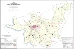 Map showing Kadipur CD block | |
 Kadipur Location in Uttar Pradesh, India 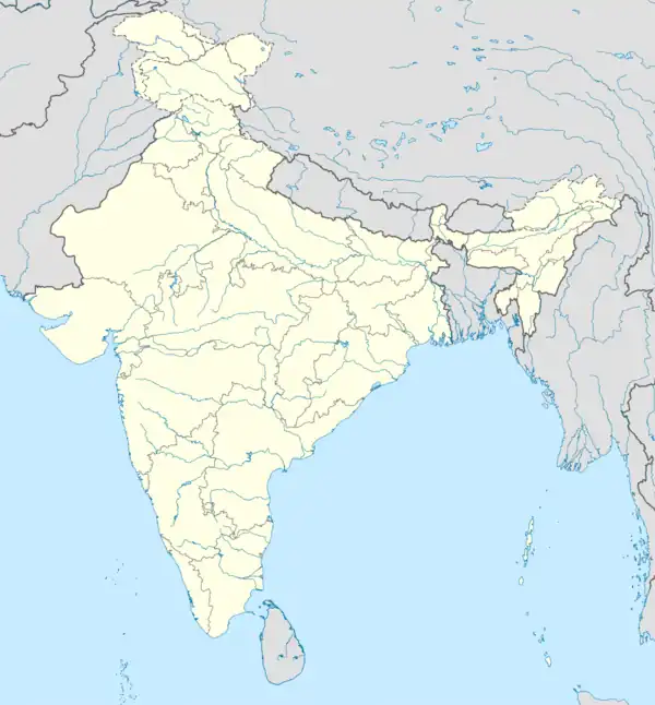 Kadipur Kadipur (India) | |
| Coordinates: 26.17°N 82.38°E | |
| Country | |
| State | Uttar Pradesh |
| District | Sultanpur |
| Area | |
| • Total | 4 km2 (2 sq mi) |
| Elevation | 90 m (300 ft) |
| Population (2011)[2] | |
| • Total | 8,010 |
| • Density | 2,000/km2 (5,200/sq mi) |
| Language | |
| • Official | Hindi[3] |
| • Additional official | Urdu[3] |
| • Regional | Awadhi |
| Time zone | UTC+5:30 (IST) |
| PIN | 228145 |
| Vehicle registration | UP-44 |
| Blocks | Dostpur, Akhand Nagar, Kadipur, Karaundi Kala |
Kadipur tehsil has 4 blocks: Akhand Nagar, Dostpur, Kadipur and Karaundi Kala. The Chairman of Kadipur is Vijay Bhan Singh.
Geography
Kadipur is located at 26.17°N 82.38°E.[6] It has an average elevation of 90 metres (295 feet).
It is situated on the bank of Gomti River.
History
Kadipur was historically a relatively minor village without any particular importance until it was made the headquarters of a tehsil.[5] It was chosen mainly because it was centrally located within the tehsil.[5] At the turn of the 20th century, Kadipur had the tehsil offices, a thana, a pound, and a thriving upper primary school.[5] It also had a bazar, which was described as "a very small one for a tahsili town".[5] A village bank had also been established.[5] As of 1901, its population was 793, with the majority of the population being Brahmins.[5] Kadipur was then held by some minor Rajkumar zamindars, with some of the Brahmins holding under-proprietary rights.[5]
Demographics
| Year | Pop. | ±% |
|---|---|---|
| 1991 | 5,235 | — |
| 2001 | 6,794 | +29.8% |
| 2011 | 8,010 | +17.9% |
| Source: 2011 Census of India[1] | ||
As of 2011 Indian Census, Kadipur had a total population of 8,010, of which 4,114 were males and 3,896 were females. Population within the age group of 0 to 6 years was 1,083. The total number of literates in Kadipur was 5,571, which constituted 69.6% of the population with male literacy of 75.6% and female literacy of 63.1%. The effective literacy rate of 7+ population of Kadipur was 80.4%, of which male literacy rate was 87.2% and female literacy rate was 73.2%. The Scheduled Castes population was 1,304. Kadipur had 1216 households in 2011.[2]
According to the 2001 census, Kadipur had a population of 6795. Males constitute 53% of the population and females 47%. Kadipur has an average literacy rate of 62%, higher than the national average of 59.5%: male literacy is 69%, and female literacy is 55%. In Kadipur, 16% of the population is under 6 years of age.[7]
Amenities
As of 2011, Kadipur has 2 hospitals with a total of 34 beds.[1] It has 17 primary schools.[1] There is no public library.A fire station is under construction on Chanda Road almost one kilometre from the Patel Chowk; .[1] Wastewater and sewage are disposed of using an open drainage system.[1] Water supply comes from both tube well and hand pump sources.[1]
Villages
Kadipur CD block has the following 94 villages:[1]
| Village name | Total land area (hectares) | Population (in 2011) |
|---|---|---|
| Taukalpur | 94.3 | 417 |
| Dhanepur | 65 | 557 |
| Banauta | 115.1 | 1,027 |
| Andaraypur | 298 | 2,692 |
| Kotiya | 97.2 | 592 |
| Salahpur | 113.3 | 707 |
| Budhana | 96.2 | 823 |
| Madanpur Kalan | 230.6 | 1,084 |
| Laxmanpur | 161.2 | 2,332 |
| Arjanipur | 38.4 | 534 |
| Higungapur | 76.1 | 897 |
| Malapur Jagdishpur | 296.3 | 3,579 |
| Chandnaia | 65.8 | 457 |
| Lauhara | 88.3 | 1,020 |
| Bhuwapur Sazaia | 51.6 | 194 |
| Kakana | 144.7 | 2,026 |
| Amrathuo Dadiya | 483 | 3,079 |
| Hamjapur Pathan | 185.3 | 2,601 |
| Bankegan | 733.6 | 7,223 |
| Chatur Khijrabad | 62.3 | 473 |
| Pandela | 126.5 | 1,360 |
| Daulatpur | 111.6 | 1,261 |
| Gaura Bibipur | 193.9 | 1,759 |
| Mangrawa | 175 | 1,871 |
| Kalikapur | 174.4 | 1,255 |
| Katghara Khurd | 88.2 | 721 |
| Kaymaspur | 92.3 | 149 |
| Kamrawan | 163.5 | 1,526 |
| Raibigo | 909.6 | 5,933 |
| Karsari | 549.1 | 4,963 |
| Baruaaripur | 208 | 4,214 |
| Katghar Mutarwahi | 116.6 | 545 |
| Ganapur | 37.9 | 2 |
| Saidpur Kalan | 80.1 | 637 |
| Bachhapara | 59.4 | 634 |
| Khijarabad | 56.2 | 203 |
| Bhimalpur | 43.8 | 306 |
| Narayanapara | 59.4 | 1,008 |
| Gopalpur Newajpur | 246.2 | 2,293 |
| Ranipur Kaysth | 246.2 | 2,293 |
| Bhaluaahi | 31.2 | 473 |
| Mustfabad | 32.1 | 0 |
| Aldamaoo Noorpur | 165.1 | 1,293 |
| Makhdoompur | 38.6 | 0 |
| Bhikhpur Aqbalpur | 53.8 | 115 |
| Khatiwpur | 63.3 | 1,158 |
| Saraykalyan | 86.6 | 1,563 |
| Jalalpur | 209.6 | 2,474 |
| Mohammdabad | 66.8 | 1,469 |
| Mithanepur | 19.9 | 816 |
| Bakshoopur | 26.2 | 106 |
| Nasirpur Saidan | 64.1 | 638 |
| Paharpur Shrirampur | 182.1 | 2,308 |
| Bhadaiya | 30.3 | 396 |
| Aasaipur | 18.8 | 350 |
| Prannathpur | 67.7 | 503 |
| Sarayani | 305.2 | 2,890 |
| Prannathpur Khurd | 53.3 | 211 |
| Sangapur | 56.2 | 262 |
| Kadipurkhurd | 387.7 | 3,491 |
| Saraya Kamaura | 113.6 | 1,057 |
| Taukalpur Nagara | 87.6 | 3,461 |
| Khandaura | 147.5 | 1,474 |
| Tailokpur Newada | 410.8 | 1,426 |
| Jafapur | 107.9 | 1,394 |
| Narottam | 99.8 | 1,067 |
| Pokhadaha | 129.8 | 1,586 |
| Laghaura | 68.6 | 897 |
| Bhawanipur | 66.1 | 1,337 |
| Bijethuaa Rajapur | 285.6 | 3,307 |
| Jalalpur Bakhra | 148.1 | 1,743 |
| Kumhi | 525.6 | 4,367 |
| Palidawapur | 256.9 | 2,576 |
| Hamidpur | 127.2 | 1,422 |
| Khalispur Mubarakpur | 254.1 | 2,394 |
| Katghara | 70.4 | 939 |
| Rohiyawa | 82.2 | 761 |
| Bahorapur | 139.1 | 735 |
| Biraiepur Bhatpura | 294.5 | 2,821 |
| Gangapur | 52.5 | 359 |
| Jalapur Rohiyawan | 115.8 | 652 |
| Sukhaoopur | 103.1 | 3 |
| Rampur Ukhtanda | 75.2 | 205 |
| Paharpur Basya | 298.1 | 1,154 |
| Sizilpur | 192.9 | 1,505 |
| Bari | 244.8 | 1,638 |
| Malipurnunra | 434.4 | 3,658 |
| Mudaladin | 183.5 | 1,425 |
| Rampur Khurd | 151.1 | 1,349 |
| Karopi | 126.7 | 1,053 |
| Majhgawan | 474 | 3,257 |
| Kumaihamjapur | 139 | 1,218 |
| Bhiti Paharpur | 125 | 1,318 |
References
- "Census of India 2011: Uttar Pradesh District Census Handbook - Sultanpur, Part A (Village and Town Directory)" (PDF). Census 2011 India. pp. 521–38, 758–73. Retrieved 30 November 2021.
- "Census of India: Kadipur". www.censusindia.gov.in. Retrieved 17 January 2020.
- "52nd Report of the Commissioner for Linguistic Minorities in India" (PDF). nclm.nic.in. Ministry of Minority Affairs. Archived from the original (PDF) on 25 May 2017. Retrieved 11 January 2019.
- "Pin Code: KADIPUR, SULTANPUR, UTTAR PRADESH, India, Pincode.net.in". pincode.net.in. Retrieved 17 January 2020.
- Nevill, H.R. (1903). Sultanpur: A Gazetteer, Being Volume XLVI Of The District Gazetteers Of The United Provinces Of Agra And Oudh. Allahabad: Government Press. pp. 187–9. Retrieved 30 November 2021.
- Falling Rain Genomics, Inc - Kadipur
- "Census of India 2001: Data from the 2001 Census, including cities, villages and towns (Provisional)". Census Commission of India. Archived from the original on 16 June 2004. Retrieved 1 November 2008.