Jambi (city)
Jambi is the capital and largest city of the Indonesian province of Jambi. Located on the island of Sumatra, the city is a busy port on the Batang Hari River and an oil- and rubber-producing centre. The city is located 26 km (16 mi) from the ruins of Muaro Jambi Temple Compounds, an important city in the ancient Srivijaya kingdom.
Jambi | |
|---|---|
| City of Jambi Kota Jambi | |
| Other transcription(s) | |
| • Jawi | بندارايا جمبي |
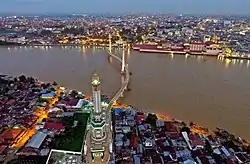 Jambi city in evening | |
 Flag  Coat of arms | |
| Motto(s): Tanah Pilih Pesako Betuah (Chosen Land with Auspicious Heritage) | |
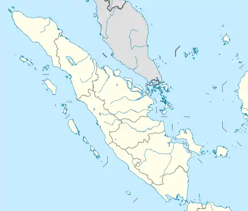
 Location within Jambi Province | |
| Coordinates: 1°35′24″S 103°36′36″E | |
| Country | |
| Region | Sumatra |
| Province | |
| Founded | 17 May 1401 |
| City Status | 1956 |
| Government | |
| • Mayor | Syarif Fasha (Golkar) |
| • Vice Mayor | Maulana |
| Area | |
| • Total | 205.38 km2 (79.30 sq mi) |
| Elevation | 16 m (52 ft) |
| Population (mid 2022 estimate) | |
| • Total | 619,553 |
| • Density | 3,000/km2 (7,800/sq mi) |
| [1] | |
| Time zone | UTC+7 (Indonesia Western Time) |
| Area code | (+62) 741 |
| Website | jambikota.go.id |

.jpg.webp)
Nearby towns and villages include Mendalo (5.1 nmi (9.4 km; 5.9 mi)), Kinati (4.1 nmi (7.6 km; 4.7 mi)), Padang (4.5 nmi (8.3 km; 5.2 mi)), Tanjungjohor (3.2 nmi (5.9 km; 3.7 mi)), Paalmerah (2.8 nmi (5.2 km; 3.2 mi)), and Muarakumpe (3.6 nmi (6.7 km; 4.1 mi)). Jambi City itself is an enclave within Muaro Jambi Regency.
Jambi is served by the Sultan Thaha Airport.
History
Jambi City was denoted as the administrative capital of the Jambi autonomic area by the Governor of Sumatra on 17 May 1946. In 1956, Jambi City was given its city status, and eventually became the capital of Jambi province on 6 January 1957.
Geography
The total land area of Jambi city is 205.38 km2 (79 sq mi). Jambi City is located at the south-western portion of the Sumatran Basin, a low-lying area in Eastern Sumatra with an altitude of 0 to 60m above sea level. A segment of the Batanghari River, the longest river in Sumatra at 1,700 km (1,056 mi), flows through Jambi City.
Demographics
Jambi city is the most populated city in Jambi Province, with 606,200 inhabitants (17% of the province's population) living in this city in 2020;[3] the official estimate as at mid 2022 was 619,553 (comprising 311,616 males and 307,937 females).[1] The city is a very diverse and multi-ethnic, consist of Jambi Malays (27.84%), Javanese (22.05%), Minangkabau (12.64%), Malays (11.47%), Chinese (6.82%), Batak (6.62%), Sundanese (4.47%), and Bugis (2.03%).[2]
Administrative districts
At the time of the 2010 Census, the city of Jambi was subdivided into eight administrative districts (kecamatan), but since 2010, three additional districts have been added by the splitting of existing districts - Alam Barajo, Danau Sipin and Paal Merah. The districts are listed below with their areas and their populations at the 2010 Census[4] and 2020 Census,[3] together with the official estimates as at mid 2022.[1] The table also includes the locations of the district administrative centres, the number of administrative villages (urban kelurahan) in each district, and its post codes.
| Name of District (kecamatan) | Area in km2 | Pop'n 2010 Census | Pop'n 2020 Census | Pop'n mid 2022 Estimate | Admin centre | No. of villages | Post codes |
|---|---|---|---|---|---|---|---|
| Kota Baru | 36.11 | 139,359 | 80,062 | 83,381 | Paal Lima | 5 | 36126 - 36128 |
| Alam Baraja | 41.56 | (a) | 108,196 | 113,146 | Bagan Pete | 5 | 36125 - 36129 |
| Jambi Selatan (South Jambi) | 11.41 | 124,280 | 56,929 | 57,515 | Pakuan Baru | 5 | 36131 - 36139 |
| Paal Merah | 27.13 | (a) | 105,906 | 108,182 | Talang Bakung | 5 | 36139 - 36148 |
| Jelutung | 7.92 | 60,544 | 59,442 | 59,744 | Jelutung | 7 | 36133 - 36137 |
| Pasar Jambi | 4.02 | 12,800 | 11,193 | 11,147 | Pasar | 4 | 36111 - 36134 |
| Telanaipura | 22.51 | 92,366 | 49,212 | 49,734 | Telanai Pura | 6 | 36122 - 36129 |
| Danau Sipin | 7.88 | (a) | 43,375 | 43,734 | Murni | 5 | 36121 - 36129 |
| Danau Teluk | 15.70 | 11,824 | 12,822 | 13,009 | Olak Kemang | 5 | 36261 - 36265 |
| Pelayangan | 15.29 | 12,861 | 12,939 | 13,050 | Ulu Gedong | 6 | 36251 - 36256 |
| Jambi Timur (East Jambi) | 15.94 | 77,823 | 66,124 | 66,925 | Tanjung Pinang | 9 | 36141 - 36149 |
| Totals | 205.38 | 531,857 | 606,200 | 619,553 | Kota Baru | 62 |
Note: (a) the 2010 populations of these new districts are included with the figure for the district from which they were cut.
Climate
Jambi has a tropical rainforest climate (Af) according to the Köppen climate classification, with a minimum temperature of 22 to 23 °C (72 to 73 °F) and a maximum temperature of 30 to 32 °C (86 to 90 °F). The level of humidity ranges from 82 to 28%. Annual rainfall of Jambi City is 2,296.1 mm (90.4 in), with the rainy season lasting from October to March with 20 rainy days a month. The dry season lasts from April to September with an average of 16 rainy days a month.
| Climate data for Jambi (Sultan Thaha Syaifuddin Airport, 1991–2020 normals) | |||||||||||||
|---|---|---|---|---|---|---|---|---|---|---|---|---|---|
| Month | Jan | Feb | Mar | Apr | May | Jun | Jul | Aug | Sep | Oct | Nov | Dec | Year |
| Average high °C (°F) | 30.7 (87.3) |
31.3 (88.3) |
31.9 (89.4) |
32.3 (90.1) |
32.4 (90.3) |
32.3 (90.1) |
32.0 (89.6) |
32.3 (90.1) |
32.3 (90.1) |
32.1 (89.8) |
31.8 (89.2) |
31.1 (88.0) |
31.9 (89.4) |
| Daily mean °C (°F) | 26.5 (79.7) |
26.6 (79.9) |
26.8 (80.2) |
27.1 (80.8) |
27.3 (81.1) |
27.2 (81.0) |
26.9 (80.4) |
27.0 (80.6) |
27.0 (80.6) |
26.9 (80.4) |
26.8 (80.2) |
26.6 (79.9) |
26.9 (80.4) |
| Average low °C (°F) | 23.3 (73.9) |
23.2 (73.8) |
23.2 (73.8) |
23.4 (74.1) |
23.6 (74.5) |
23.3 (73.9) |
22.8 (73.0) |
22.8 (73.0) |
22.9 (73.2) |
23.1 (73.6) |
23.2 (73.8) |
23.3 (73.9) |
23.2 (73.8) |
| Average precipitation mm (inches) | 218 (8.6) |
193 (7.6) |
252 (9.9) |
257 (10.1) |
180 (7.1) |
124 (4.9) |
106 (4.2) |
133 (5.2) |
151 (5.9) |
209 (8.2) |
270 (10.6) |
254 (10.0) |
2,347 (92.3) |
| Mean monthly sunshine hours | 101.8 | 103.7 | 114.9 | 130.7 | 149.0 | 159.1 | 171.6 | 164.0 | 128.4 | 114.5 | 107.4 | 98.9 | 1,544 |
| Source 1: World Meteorological Organization[5] | |||||||||||||
| Source 2: Climate-Data.org (precipitation)[6] | |||||||||||||
Transportation

The city is served by Sultan Thaha Airport, which has connections to Jakarta, Batam, Palembang, Medan, Bengkulu, Bandar Lampung and Pekanbaru. Trans-Sumatran Highway crosses the city. Jambi port is located over Batang Hari River. Public transportation includes angkot and ojek. Ride sharing services Grab and Gojek also available
Media
The oldest newspaper in the Jambi region is Jambi Independent, part of Jawa Pos Group. Several other newspapers such as Tribun Jambi, Jambi Ekspres and Metro Jambi are also available.
The privately owned Jek TV and Jambi TV are the local TV stations based in Jambi. The public TVRI Jambi also covers the city.
Twin towns – sister cities
Jambi City is twinned with:
References
- Badan Pusat Statistik, Jakarta, 2023, Kota Jambi Dalam Angka 2023 (Katalog-BPS 1102001.1571)
- Badan Pusat Statistik Provinsi Jambi
- Badan Pusat Statistik, Jakarta, 2021.
- Biro Pusat Statistik, Jakarta, 2011.
- "World Meteorological Organization Climate Normals for 1991–2020". World Meteorological Organization. Retrieved 19 October 2023.
- "Climate: Jambi". Climate-Data.org. Retrieved 19 April 2020.
External links
- Official site
- Provinsi Jambi
- Sarolangun
- Informasi Jambi
- Kabar Jambi
- Merangin
- Tv Jambi
- Informasi Jambi
- Tentang Jambi
- Tv Online Jambi
- Pariwisata Jambi
- Berita Jambi
- Muaro Jambi
Provincial capitals in Indonesia | ||
|---|---|---|
| Sumatra | ||
| Java | ||
| Kalimantan | ||
| Lesser Sunda | ||
| Sulawesi | ||
| Maluku | ||
| Papua | ||
| Former provincial capitals | ||
| 2,000,000 and more | |
|---|---|
| 1,000,000–1,999,999 | |
| 500,000–999,999 | |
| 300,000–499,999 | |
| 200,000–299,999 | |