Jenkins County, Georgia
Jenkins County is a county located in the southeastern area of the U.S. state of Georgia. As of the 2020 census, the population was 8,674.[1] The county seat is Millen.[2] Historic and bountiful Magnolia Springs State Park is located between Millen and Perkins.
Jenkins County | |
|---|---|
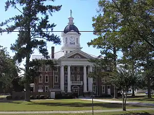 Jenkins County Courthouse, in Millen | |
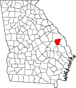 Location within the U.S. state of Georgia | |
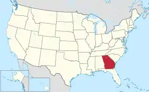 Georgia's location within the U.S. | |
| Coordinates: 32°47′N 81°58′W | |
| Country | |
| State | |
| Founded | August 17, 1905 |
| Named for | Charles Jones Jenkins |
| Seat | Millen |
| Largest city | Millen |
| Area | |
| • Total | 352 sq mi (910 km2) |
| • Land | 347 sq mi (900 km2) |
| • Water | 5.2 sq mi (13 km2) 1.5% |
| Population (2020) | |
| • Total | 8,674 |
| • Density | 25/sq mi (10/km2) |
| Time zone | UTC−5 (Eastern) |
| • Summer (DST) | UTC−4 (EDT) |
| Congressional district | 12th |
| Website | www |
History
Jenkins County was created on August 17, 1905, from portions of Bulloch, Burke, Emanuel and Screven counties, and named after the 44th Governor of Georgia, Charles Jones Jenkins.[3] The effort was spearheaded by Robert Gray Daniel (d. 14 May 1934), a director of the local Millen Bank, a 40-year member of the board of education and scion of the county's Daniel family who had large mercantile and farming enterprises.[4] The effect was to place the county seat of Millen in a position where the town could become a safe place for economic growth. But the first decade after formation was difficult due to lack of realistic economic planning and implementation. Local people were leaving for jobs in larger cities, and there were few new business start-ups.
During the Red Summer of 1919, there was a race riot on April 13, 1919 in Jenkins County, in which white mobs attacked the black community. Prosperous and respected local farmer Joe Ruffin, whose family had historically been slaves working the plantations of the Daniel family, was almost impoverished by the costs of his legal defense and vindication.[5]
Businesses in the county attract their workforce from throughout the area. Because the county population is relatively small, people notice that when jobs increase, the population increases. When an employer closes its business, the local population decreases as people seek opportunities elsewhere. For a number of years, the largest employer was Jockey International which employed manual and skilled laborers until reducing then closing operations in September 2007.[6] MI Windows and Doors had a long presence in the county at its manufacturing plant, closing in December 2007.[6]
Jenkins County owns the Millen Airport, which was established to increase local and regional transportation flexibility. Annual assessments show the airport has provided consistent benefit to the people and businesses in the county.[7]
Geography
According to the U.S. Census Bureau, the county has a total area of 352 square miles (910 km2), of which 347 square miles (900 km2) is land and 5.2 square miles (13 km2) (1.5%) is water.[8]
Most of the southern portion of Jenkins County, from southwest of Millen to west of Hiltonia, is located in the Lower Ogeechee River sub-basin of the Ogeechee River basin, with the exception of very small parts of the southwestern corner of the county, north and east of Garfield, which are located in the Canoochee River sub-basin of the same Ogeechee River basin. The northwestern portion of Jenkins County is located in the Upper Ogeechee River sub-basin of the Ogeechee River basin, with just the northeastern corner of the county located in the Brier Creek sub-basin of the Savannah River basin.[9]
Major highways
Adjacent counties
- Burke County (north)
- Screven County (east)
- Bulloch County (south)
- Emanuel County (west)
Demographics
| Census | Pop. | Note | %± |
|---|---|---|---|
| 1910 | 11,520 | — | |
| 1920 | 14,328 | 24.4% | |
| 1930 | 12,908 | −9.9% | |
| 1940 | 11,843 | −8.3% | |
| 1950 | 10,264 | −13.3% | |
| 1960 | 9,148 | −10.9% | |
| 1970 | 8,332 | −8.9% | |
| 1980 | 8,841 | 6.1% | |
| 1990 | 8,247 | −6.7% | |
| 2000 | 8,575 | 4.0% | |
| 2010 | 8,340 | −2.7% | |
| 2020 | 8,674 | 4.0% | |
| U.S. Decennial Census[10] 1790-1960[11] 1900-1990[12] 1990-2000[13] 2010-2013[14] | |||
2000 census
As of the census[15] of 2000, there were 8,575 people, 3,214 households, and 2,269 families living in the county. The population density was 24 people per square mile (9.3 people/km2). There were 3,907 housing units at an average density of 11 per square mile (4.2/km2). The racial makeup of the county was 56.29% White, 40.49% Black or African American, 0.15% Native American, 0.21% Asian, 0.09% Pacific Islander, 2.06% from other races, and 0.70% from two or more races. 3.35% of the population were Hispanic or Latino of any race.
There were 3,214 households, out of which 33.70% had children under the age of 18 living with them, 45.90% were married couples living together, 19.70% had a female householder with no husband present, and 29.40% were non-families. 25.60% of all households were made up of individuals, and 11.30% had someone living alone who was 65 years of age or older. The average household size was 2.63 and the average family size was 3.16.
In the county, the population was spread out, with 28.50% under the age of 18, 9.20% from 18 to 24, 26.40% from 25 to 44, 22.30% from 45 to 64, and 13.60% who were 65 years of age or older. The median age was 35 years. For every 100 females there were 92.00 males. For every 100 females age 18 and over, there were 86.70 males.
The median income for a household in the county was $24,025, and the median income for a family was $29,539. Males had a median income of $28,804 versus $20,252 for females. The per capita income for the county was $13,400. About 22.30% of families and 28.40% of the population were below the poverty line, including 39.60% of those under age 18 and 25.50% of those age 65 or over.
2010 census
As of the 2010 United States Census, there were 8,340 people, 3,192 households, and 2,164 families living in the county.[16] The population density was 24.0 inhabitants per square mile (9.3/km2). There were 4,221 housing units at an average density of 12.2 per square mile (4.7/km2).[17] The racial makeup of the county was 54.9% white, 40.5% black or African American, 0.4% Asian, 0.3% American Indian, 2.6% from other races, and 1.2% from two or more races. Those of Hispanic or Latino origin made up 4.0% of the population.[16] In terms of ancestry, 13.0% were American, 10.1% were English, 7.4% were Irish, and 6.3% were German.[18]
Of the 3,192 households, 34.7% had children under the age of 18 living with them, 42.1% were married couples living together, 20.3% had a female householder with no husband present, 32.2% were non-families, and 28.7% of all households were made up of individuals. The average household size was 2.59 and the average family size was 3.16. The median age was 38.2 years.[16]
The median income for a household in the county was $27,686 and the median income for a family was $35,876. Males had a median income of $36,391 versus $25,814 for females. The per capita income for the county was $17,629. About 17.6% of families and 19.1% of the population were below the poverty line, including 24.1% of those under age 18 and 20.8% of those age 65 or over.[19]
2020 census
| Race | Num. | Perc. |
|---|---|---|
| White (non-Hispanic) | 4,611 | 53.16% |
| Black or African American (non-Hispanic) | 3,536 | 40.77% |
| Native American | 29 | 0.33% |
| Asian | 12 | 0.14% |
| Pacific Islander | 5 | 0.06% |
| Other/Mixed | 178 | 2.05% |
| Hispanic or Latino | 303 | 3.49% |
As of the 2020 United States census, there were 8,674 people, 3,443 households, and 2,095 families residing in the county.
Politics
| Year | Republican | Democratic | Third party | |||
|---|---|---|---|---|---|---|
| No. | % | No. | % | No. | % | |
| 2020 | 2,161 | 62.55% | 1,266 | 36.64% | 28 | 0.81% |
| 2016 | 1,895 | 62.01% | 1,123 | 36.75% | 38 | 1.24% |
| 2012 | 1,887 | 55.60% | 1,488 | 43.84% | 19 | 0.56% |
| 2008 | 1,936 | 56.25% | 1,482 | 43.06% | 24 | 0.70% |
| 2004 | 1,898 | 55.74% | 1,494 | 43.88% | 13 | 0.38% |
| 2000 | 1,317 | 50.79% | 1,250 | 48.21% | 26 | 1.00% |
| 1996 | 955 | 38.77% | 1,336 | 54.24% | 172 | 6.98% |
| 1992 | 929 | 34.05% | 1,401 | 51.36% | 398 | 14.59% |
| 1988 | 1,288 | 57.30% | 953 | 42.39% | 7 | 0.31% |
| 1984 | 1,399 | 55.80% | 1,108 | 44.20% | 0 | 0.00% |
| 1980 | 824 | 33.05% | 1,632 | 65.46% | 37 | 1.48% |
| 1976 | 563 | 23.63% | 1,820 | 76.37% | 0 | 0.00% |
| 1972 | 1,769 | 78.52% | 484 | 21.48% | 0 | 0.00% |
| 1968 | 574 | 22.71% | 704 | 27.86% | 1,249 | 49.43% |
| 1964 | 1,509 | 62.43% | 908 | 37.57% | 0 | 0.00% |
| 1960 | 313 | 18.78% | 1,354 | 81.22% | 0 | 0.00% |
| 1956 | 261 | 20.70% | 1,000 | 79.30% | 0 | 0.00% |
| 1952 | 368 | 23.99% | 1,166 | 76.01% | 0 | 0.00% |
| 1948 | 98 | 10.11% | 595 | 61.40% | 276 | 28.48% |
| 1944 | 101 | 12.64% | 698 | 87.36% | 0 | 0.00% |
| 1940 | 69 | 6.82% | 940 | 92.98% | 2 | 0.20% |
| 1936 | 32 | 3.51% | 880 | 96.49% | 0 | 0.00% |
| 1932 | 20 | 3.77% | 510 | 96.23% | 0 | 0.00% |
| 1928 | 332 | 44.80% | 409 | 55.20% | 0 | 0.00% |
| 1924 | 16 | 6.67% | 200 | 83.33% | 24 | 10.00% |
| 1920 | 49 | 12.89% | 331 | 87.11% | 0 | 0.00% |
| 1916 | 20 | 4.66% | 402 | 93.71% | 7 | 1.63% |
| 1912 | 17 | 5.70% | 272 | 91.28% | 9 | 3.02% |
See also
References
- "Census - Geography Profile: Jenkins County, Georgia". United States Census Bureau. Retrieved December 27, 2022.
- "Find a County". National Association of Counties. Archived from the original on May 9, 2015. Retrieved June 7, 2011.
- Krakow, Kenneth K. (1975). Georgia Place-Names: Their History and Origins (PDF). Macon, GA: Winship Press. p. 120. ISBN 0-915430-00-2. Archived (PDF) from the original on September 17, 2003.
- "Operation Fatal for R.G. Daniel Leading Millen Citizen. Butler Herald (Butler, Georgia) May 17, 1934. Accessed via genealogytrails.com on 26 Apr 2023.
- oe Ruffin Wins Vindication Savannah. Cumming North Georgian (Cumming, Georgia) June 8, 1923. Accessed via genealogytrails.com on 26 Apr 2023.
- "Plant Closing Devastates Millen". Statesboro Herald, updated Nov 19, 2007. Accessed 26 April 2023.
- Economic Impact Report for Millen Airport. Georgia Department of Transportation. September 2020. Accessed 26 April 2023.
- "US Gazetteer files: 2010, 2000, and 1990". United States Census Bureau. February 12, 2011. Retrieved April 23, 2011.
- "Georgia Soil and Water Conservation Commission Interactive Mapping Experience". Georgia Soil and Water Conservation Commission. Archived from the original on October 3, 2018. Retrieved November 20, 2015.
- "U.S. Decennial Census". United States Census Bureau. Retrieved June 23, 2014.
- "Historical Census Browser". University of Virginia Library. Retrieved June 23, 2014.
- "Population of Counties by Decennial Census: 1900 to 1990". United States Census Bureau. Retrieved June 23, 2014.
- "Census 2000 PHC-T-4. Ranking Tables for Counties: 1990 and 2000" (PDF). United States Census Bureau. Archived (PDF) from the original on March 27, 2010. Retrieved June 23, 2014.
- "State & County QuickFacts". United States Census Bureau. Archived from the original on June 7, 2011. Retrieved June 23, 2014.
- "U.S. Census website". United States Census Bureau. Retrieved May 14, 2011.
- "DP-1 Profile of General Population and Housing Characteristics: 2010 Demographic Profile Data". United States Census Bureau. Archived from the original on February 13, 2020. Retrieved December 30, 2015.
- "Population, Housing Units, Area, and Density: 2010 - County". United States Census Bureau. Archived from the original on February 13, 2020. Retrieved December 30, 2015.
- "DP02 SELECTED SOCIAL CHARACTERISTICS IN THE UNITED STATES – 2006-2010 American Community Survey 5-Year Estimates". United States Census Bureau. Archived from the original on February 13, 2020. Retrieved December 30, 2015.
- "DP03 SELECTED ECONOMIC CHARACTERISTICS – 2006-2010 American Community Survey 5-Year Estimates". United States Census Bureau. Archived from the original on February 13, 2020. Retrieved December 30, 2015.
- "Explore Census Data". data.census.gov. Retrieved December 14, 2021.
- Leip, David. "Dave Leip's Atlas of U.S. Presidential Elections". uselectionatlas.org. Retrieved March 20, 2018.
Places adjacent to Jenkins County, Georgia | ||||||||||||||||
|---|---|---|---|---|---|---|---|---|---|---|---|---|---|---|---|---|
| ||||||||||||||||
Municipalities and communities of Jenkins County, Georgia, United States | ||
|---|---|---|
| City | Map of Georgia highlighting Jenkins County | |
| CDP | ||
| Unincorporated communities | ||