Jhenaidah District
Jhenaidah District (Bengali: ঝিনাইদহ) is a district in southwestern Bangladesh. It is a part of the Khulna Division. It has an area of 1,964.77 km2 (758.60 sq mi).[3] It is bordered by Kushtia District to the north, Jessore District and West Bengal, India to the south, Rajbari District and Magura District to the east, and Chuadanga District and West Bengal, India to the west. The largest city and headquarter of this district is Jhenaidah.[4] At the beginning of the British rule Jhenaidah was a police outpost and was turned into a thana in 1793. The Jhenaidah Sub division was established in 1862 and was turned into a district in 1984.[5]
Jhenaidah District
ঝিনাইদহ | |
|---|---|
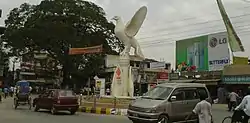 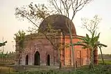 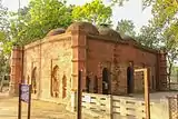 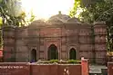 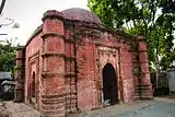 From top: Payra chattar, Jhenaidah NunGola Masjid, Jhenaidah Golakata Mosque, Pir Pukur Masjid, Pathaghar Dhibi | |
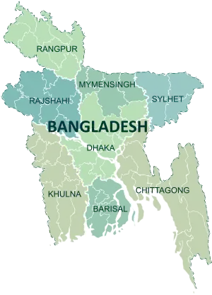
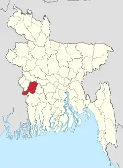 Location of Jhenaidah District in Bangladesh | |
Expandable map of Jhenaidah District | |
| Coordinates: 23.54°N 89.00°E | |
| Country | |
| Division | Khulna Division |
| Government | |
| • Deputy Commissioner | Monira Begum |
| Area | |
| • Total | 1,964.77 km2 (758.60 sq mi) |
| Population (2022)[1] | |
| • Total | 2,005,849 |
| • Density | 1,000/km2 (2,600/sq mi) |
| Time zone | UTC+06:00 (BST) |
| HDI (2019) | 0.644[2] medium · 5th of 20 |
Geography
Annual average temperature: maximum 37.1 °C (98.8 °F), minimum 11.2 °C (52.2 °F) Annual rainfall: 1,467 mm (57.8 in)[6]
Demographics
| Year | Pop. | ±% p.a. |
|---|---|---|
| 1974 | 976,192 | — |
| 1981 | 1,109,875 | +1.85% |
| 1991 | 1,361,280 | +2.06% |
| 2001 | 1,579,490 | +1.50% |
| 2011 | 1,771,304 | +1.15% |
| 2022 | 2,005,849 | +1.14% |
| Sources:[1][7] | ||
According to the 2022 Census of Bangladesh, Jhenaidah District had 519,296 households and a population of 2,005,849, 21.1% of whom lived in urban areas. The population density was 1,021 people per km2. The literacy rate (age 7 and over) was 72.7%, compared to the national average of 74.7%.[1]
| Religion | Population (1941)[8]: 86–87 | Percentage (1941) | Population (2011)[7] | Percentage (2011) |
|---|---|---|---|---|
| Islam |
293,886 | 65.40% | 1,601,186 | 90.39% |
| Hinduism |
154,115 | 34.29% | 167,880 | 9.48% |
| Others [lower-alpha 2] | 1,386 | 0.31% | 2,238 | 0.13% |
| Total Population | 449,387 | 100% | 1,771,304 | 100% |
Archeological heritage
- Biswabat, Bethuli
- Harihar Garh, Shailkupa
- Shailkupa Jami Mosque, Shailkupa
- Ram Gopal Mandir, Shailkupa
- Kharer Dighi Mosque, Kaliganj
- Jahajghata, Kaliganj
- Sawdaghar Dighi and Mosque
- Gorai Mosque, Kaliganj
- Jor Bangla Mosque, Kaliganj
- Galakata Dighi and Mosque, Kaliganj
- Cheragdani Dighi and Mosque
- Dighi of Sree Ram Raja
- Tombs of Ghazi, Kalu & Champabati, Kaliganj
- Dhol Samudra Dighi, Jhenaidah Sadar
- Naldangha Rajbari and Mandir, Kaliganj
- Manasa Mandir, Maheshpur
- Krishna Balaram Dev Bigraha Mandir, Kaliganj
- Neel Kuthi, Madhupur, Jhenaidah Sadar
- Miyar Dalan, Jhenaidah Sadar
- Noongola Mosque, Kaliganj
- Monahar Mosque, Kaliganj
- Pirpukur Mosque, Kaliganj
- Sukur Mallik Mosque, Kaliganj
- Satgachiya Mosque, Kaliganj
- Tombs of Pagla Kanai, Jhenaidah Sadar
- Dhannoharia Purbopara Jame Mosque (Dhannoharia, Jadabpur, Moheshpur, Jhenaidah)
Administration
Deputy Commissioner: Soroj Kumar Nath[9]
Chairman of Zila Porishod: Kanak Kanti Das [10]
Subdivisions
There are six upazilas under this district:
City and towns
Jhenaidah district includes 1 municipal city Jhenaidah & 5 towns. All are governed by municipalities.
| City/town | Area (km2) | Population (2011)[7] |
|---|---|---|
| Jhenaidah | 32.42 | 107,834 |
| Kaliganj | 15.83 | 45,341 |
| Shailkupa | 20.92 | 35,271 |
| Kotchandpur | 20.16 | 33,094 |
| Maheshpur | 21.16 | 27,670 |
| Harinakunda | 22.26 | 22,011 |
Education
Colleges
- Government Birshestha Shahid Hamidur Rahman Degree College
- Government K.C. College Jhenaidah
- Government K. M. H. College, Kotchandpur
- Kotchandpur Paura Mohila Degree College
- Maheshpur Government Degree College
- Mahtab Uddin College, Kaliganj
- Moheshpur Poura Mohila Degree College
- Shahid Nur Ali College, Kaliganj
- Shailkupa Government Degree College
- Jhenaidah College
Other tertiary institutions
- Institute of Health Technology, Jhenaidah
- Jhenaidah Government Veterinary College
- Jhenaidah Polytechnic Institute
- Sheikh Kamal Textile Engineering College, Jhenaidah
School and colleges
- Jhenaidah Cadet College
- Kanchannagar Model School and College, Jhenaidah
- Shishu Kunja School & College, Jhenaidah
- Jhenaidah Govt Technical School And College,Jhenidah
Secondary schools
- Harinakunda Priyanath High School
- Jehnaidah Government High School
- Jhenaida Government Girls High School
- Joradah High School, Harinakundu
- Kola Bazar United High School, Kaliganj
- Kotchandpur Girls' High School
- Kotchandpur Govt. Model Pilot Secondary School
- Kotchandpur Secondary School (1899)
- Maheshpur High School
- Maheshpur Pilot Girls' High School
- Naldanga Bhushan Pilot Secondary School, Kaliganj
- Raigram Banikanta Secondary School
- Solimunnessa Pilot Girls High School, Kaliganj
Notable residents
Bangladeshi Islamic Scholar. 1 February 1961 – 11 May 2016), or simply known as Abdullah Jahangir, was a Bangladeshi Islamic scholar, professor, author and television presenter. He also made appearances on various national and international television channels discussing contemporary issues relating to Islam including Peace TV, ATN Bangla, NTV, Channel 9 and Islamic TV,
- Abul Hasan Jashori – Islamic scholar and freedom fighter
- Qazi Mu'tasim Billah – Islamic scholar and former professor at the University of Dhaka
- Bashir Uddin Ahmad Mazmadar- Zamindar, Lawyer, British Civil Servant Officer, Politician, member of parliament during Pakistan period, Minister of Public Works, Power and Water, close associates of Hussain Shaheed Sherwardy and Prime Minister Mohammad Ali Bogra, instrumental in establishing Jhenaidah Cadet College, Jessore Education Board and many other developments]]
- Abdul Hyee – a member of parliament, freedom fighter and commander during the Bangladesh Liberation War
- Bagha Jatin – an Indian Bengali revolutionary against British rule
- Birshrestha Hamidur Rahman – national hero, a sepoy in Bangladesh Army during the Bangladesh Liberation War
- Ila Mitra – activist, Peasants movement organizer of the Indian subcontinent, elected member of Vidhan Sabha (Provincial Assembly) four times between 1962 and 1978.
- Fakir Lalon Shah – a prominent Bengali philosopher, baul saint and social reformer
- Golam Mostofa (poet) – Bengali writer and poet
- Pagla Kanai – a Bengali mystic folk singer, baul and philosopher
- Jamal Nazrul Islam – mathematical physicist and cosmologist
- Zillur Rahman- educationist, former vice-chancellor of Jahangirnagar University
References
- Population and Housing Census 2022: Preliminary Report. Bangladesh Bureau of Statistics. August 2022. pp. viii, 29, 38, 45. ISBN 978-984-35-2977-0.
- "Sub-national HDI – Area Database – Global Data Lab". hdi.globaldatalab.org. Retrieved 18 March 2020.
- "Jhenaidah (District (Zila))". Retrieved 3 May 2013.
- BM Rezaul Karim (2012). "Jhenaidah District". In Sirajul Islam and Ahmed A. Jamal (ed.). Banglapedia: National Encyclopedia of Bangladesh (Second ed.). Asiatic Society of Bangladesh.
- "Jhenaidah District Town".
- "Jhenaidah District Town".
- "Bangladesh Population and Housing Census 2011 Zila Report – Jhenaidah" (PDF). bbs.gov.bd. Bangladesh Bureau of Statistics.
- "Census of India, 1941 Volume VI Bengal Province" (PDF). Retrieved 13 August 2022.
- মোঃ জাকির হোসেন [Md. Zakir Hossain]. Jhenaidah District. Bangladesh National Portal.
- জনপ্রতিনিধিদের তালিকা [List of representatives]. Jhenaidah District. Bangladesh National Portal.
- Jhenaida subdivision and Maheshpur thana of Bongaon subdivision of Jessore district
- Including Jainism, Christianity, Buddhism, Zoroastrianism, Judaism, Ad-Dharmis, or not stated
External links
- Map of Jhenaidah District Archived 20 August 2008 at the Wayback Machine
| Upazila/Thana: | ||
|---|---|---|