Kachankawal Rural Municipality
Kachankawal (Nepali: कचनकवल) is a rural municipality out of 7 rural municipalities of Jhapa District of Koshi Province of Nepal. There are total 15 local administrative units in Jhapa District in which 8 are urban and 7 are rural municipalities.
Kachankawal
कचनकवल | |
|---|---|
| Kachankawal Rural Municipality | |
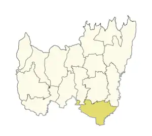 Location of Kachankawal in Jhapa District | |
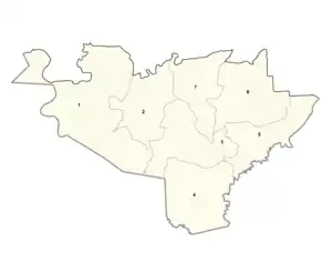 Ward divisions of Kachankawal | |
 Kachankawal Location in Koshi Province  Kachankawal Kachankawal (Nepal) | |
| Coordinates: 26.431521°N 88.033213°E | |
| Country | |
| Province | Koshi Province |
| District | Jhapa |
| Total Wards | 7 |
| Established | March 2017 |
| Seat | [Baniyani] |
| Government | |
| • Type | Rural Council |
| • Body | Kachankawal Rural Council |
| • Chairperson | Mr.Kalendra Prasad Singh Rajbanshi(NC) |
| • Vice-chairperson | Mr.Nawaraj Bhattarai(NCP,UML) |
| Area of Municipality | |
| • Total | 110 km2 (40 sq mi) |
| Population (2011) | |
| • Total | 39,593 |
| • Density | 360/km2 (930/sq mi) |
| Languages | |
| • Official | Nepali Local language Rajbanshi,[Surjapuri language] |
| Time zone | UTC+5:45 (NST) |
| Postal code | 57200 |
| Website | Official website |
Kachankawal rural municipality has an area of 110 square kilometres (42 sq mi) and total population according to the 2011 Nepal census is 39,593.[1] The rural municipality was established merging former VDCs: Gherabari, Pathariya, Kechana, Pathamari, Baniyani and Balubadi.[2]
Mr.Kalendra prasad singh Rajbanshi of Nepali Congress has elected as a chairperson of the rural municipality and Mr. Nawaraj Bhattarai of the Nepal Communist Party Yemale party elected for the vice-chairperson after the results of the local level elections held in Nepal on 27 June 2022.[3]
KachanKawal the lowest point of Nepal, which elevation is 58 m above sea level is located in this rural municipality.
Constituencies
- Parliamentary constituency: Kachankawal RM is a part of Jhapa 3 parliamentary constituency and Rajendra Prasad Lingden is the MP of Jhapa 3 who was elected in 2017 Nepalese general election, who is the candidate of Rastriya Prajatantra Party.
- Provincial constituency: Kachankawal with Bhadrapur Municipality comprises "Jhapa 3 (A)" Provincial constituency and Bhumi Prasad Rajbanshi (Nepali Congress Party) is the MLA.[4][5][6]
Demographics
At the time of the 2011 Nepal census, Kachankawal Rural municipality had a population of 39,593. Of these, 44.3% spoke Rajbanshi, 24.9% Nepali, 13.9% Urdu, 5.2% Maithili, 3.4% Santali, 2.1% Limbu, 1.4% Tamang, 0.9% Rai, 0.6% Sunwar, 0.5% Gurung, 0.5% Newar, 0.3% Bhojpuri, 0.3% Khash, 0.3% Magar, 0.2% Bengali, 0.2% Hindi, 0.2% Kisan, 0.1% Ganagai, 0.1% Mech and 0.2% other languages as their first language.[7]
In terms of ethnicity/caste, 35.5% were Rajbanshi, 14.6% Musalman, 12.9% Hill Brahmin, 8.5% Chhetri, 8.3% Gangai, 3.5% Santal, 2.3% Limbu, 1.5% Tamang, 1.4% Yadav, 1.2% Majhi, 1.1% Rai, 0.8% Newar, 0.7% Gurung, 0.7% Hajjam/Thakur, 0.6% Sunuwar, 0.5% Kami, 0.5% Magar, 0.5% Sanyasi/Dasnami, 0.4% Damai/Dholi, 0.4% Gaine, 0.4% Mallaha, 0.3% Gharti/Bhujel, 0.3% other Terai, 0.2% Dhanuk, 0.2% Halwai, 0.2% Kathabaniyan, 0.2% Sonar, 0.2% Teli, 0.1% Bantar/Sardar, 0.1% Baraee, 0.1% Terai Brahmin, 0.1% Chamar/Harijan/Ram, 0.1% Kahar, 0.1% Kalwar, 0.1% Koiri/Kushwaha, 0.1% Kumal, 0.1% Lohar, 0.1% Mali, 0.1% Mech, 0.1% Musahar, 0.1% Punjabi/Sikh, 0.1% Sarki, 0.1% Tharu and 0.5% others.[8]
In terms of religion, 79.2% were Hindu, 14.5% Muslim, 2.4% Buddhist, 2.4% Kirati, 0.7% Christian, 0.5% Prakriti and 0.2% others.[9]
In terms of literacy, 65.7% could read and write, 1.2% could only read and 33.1% could neither read nor write.[10]
References
- "Kachankawal Rural municipality in Nepal". www.citypopulation.de. 8 October 2017. Retrieved 15 March 2018.
- "कचनकवल गाउँपालिका". Ministry of Federal Affairs and General Administration. Archived from the original on 31 August 2018. Retrieved 15 March 2018.
- "Nepali Congress becomes victorious at Kachankawal Rural Municipality". www.khabarera.com. 3 July 2017. Retrieved 15 March 2018.
- "Jhapa" (PDF). Election Commission of Nepal. Retrieved 17 April 2021.
- "Election 2017Federal Parliament & Provincial Assembly". KMG. 2017. Retrieved 17 April 2021.
- "Election 2017Federal Parliament & Provincial Assembly". KMG. 2017. Retrieved 17 April 2021.
- NepalMap Language
- NepalMap Caste
- NepalMap Religion
- NepalMap Literacy
Headquarter: Bhadrapur | ||
| Rural Municipalities | 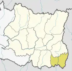 | |
| Municipalities | ||