Kamenná Horka
Kamenná Horka (German: Hermersdorf) is a municipality and village in Svitavy District in the Pardubice Region of the Czech Republic. It has about 400 inhabitants.
Kamenná Horka | |
|---|---|
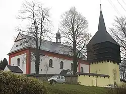 Church of Saint Mary Magdalene | |
 Flag 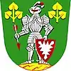 Coat of arms | |
 Kamenná Horka Location in the Czech Republic | |
| Coordinates: 49°44′17″N 16°31′26″E | |
| Country | |
| Region | Pardubice |
| District | Svitavy |
| First mentioned | 1270 |
| Area | |
| • Total | 15.74 km2 (6.08 sq mi) |
| Elevation | 521 m (1,709 ft) |
| Population (2023-01-01)[1] | |
| • Total | 365 |
| • Density | 23/km2 (60/sq mi) |
| Time zone | UTC+1 (CET) |
| • Summer (DST) | UTC+2 (CEST) |
| Postal code | 568 02 |
| Website | www |
Geography
Kamenná Horka lies approximately 4 kilometres (2 mi) east of Svitavy and 57 km (35 mi) north of Brno, on the border between the historical lands of Bohemia and Moravia. It lies in the Svitavy Uplands.
This article is issued from Wikipedia. The text is licensed under Creative Commons - Attribution - Sharealike. Additional terms may apply for the media files.