Sebranice (Svitavy District)
Sebranice is a municipality and village in Svitavy District in the Pardubice Region of the Czech Republic. It has about 1,000 inhabitants.
Sebranice | |
|---|---|
 Church of Saint Nicolas and presbytery | |
 Flag  Coat of arms | |
 Sebranice Location in the Czech Republic | |
| Coordinates: 49°46′17″N 16°14′57″E | |
| Country | |
| Region | Pardubice |
| District | Svitavy |
| First mentioned | 1347 |
| Area | |
| • Total | 11.69 km2 (4.51 sq mi) |
| Elevation | 482 m (1,581 ft) |
| Population (2023-01-01)[1] | |
| • Total | 985 |
| • Density | 84/km2 (220/sq mi) |
| Time zone | UTC+1 (CET) |
| • Summer (DST) | UTC+2 (CEST) |
| Postal codes | 569 62, 572 01 |
| Website | www |
Administrative parts
The hamlet of Vysoký Les is an administrative part of Sebranice.
Geography
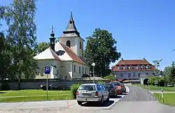
Sebranice is located about 15 kilometres (9 mi) west of Svitavy and 44 km (27 mi) southeast of Pardubice. It lies in the Svitavy Uplands. The village lies in the valley of the Jalový Stream.
History
The first written mention of Sebranice is from 1347. The municipality was created by merger of villages of Sebranice, Pohora and Kaliště and hamlets of Vysoký Les and Třemošná in 1950.[2]
Sights
The landmark of Sebranice is the Church of Saint Nicholas. It was originally a late Gothic church from the second half of the 13th century, baroque rebuilt in the late 17th and early 18th centuries. The tower was added in 1768.[3]
Gallery
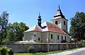 Church of Saint Nicholas
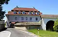 Presbytery
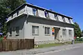 Post office
 Panorama near Sebranice
References
- "Population of Municipalities – 1 January 2023". Czech Statistical Office. 2023-05-23.
- "Historie obce". sebranice.cz (in Czech). Obec Sebranice. Retrieved 2020-11-01.
- "Kostel sv. Mikuláše" (in Czech). National Heritage Institute. Retrieved 2022-07-21.
- "Partnerská obec Zlatá Baňa" (in Czech). Obec Sebranice. Retrieved 2020-11-01.