Kargil district
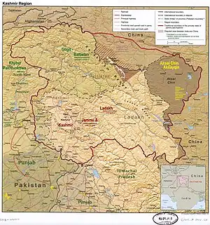
Kargil district is a district in Indian-administered Ladakh in the disputed Kashmir-region.[1] It is one of the two districts comprising the Indian-administered union territory of Ladakh. The district headquarters are in the city of Kargil. The district is bounded by the Indian-administered union territory of Jammu and Kashmir to the west, the Pakistani-administered administrative territory of Gilgit–Baltistan to the north, Ladakh's Leh district to the east, and the Indian state of Himachal Pradesh to the south. Encompassing three historical regions known as Purig, Dras and Zanskar, the district lies to the northeast of the Great Himalayas and encompasses the majority of the Zanskar Range. Its population inhabits the river valleys of the Dras, Suru, Wakha Rong, and Zanskar.
Kargil district | |
|---|---|
 View of Kargil Town | |
Interactive map of Kargil district | |
 | |
| Coordinates (Kargil): 34.56°N 76.13°E | |
| Administering country | India |
| Union Territory | Ladakh |
| Capital | Kargil |
| Established | July 1979 |
| Headquarters | Kargil |
| Tehsils | Drass, Kargil, Shargole, Shakar-Chiktan, Sankoo, Taisuru and Zanskar |
| Government | |
| • Lok Sabha constituencies | Ladakh |
| • MP | Jamyang Tsering Namgyal[2] |
| • Chief Executive Councillor | Feroz Ahmed Khan, JKNC |
| • Deputy Commissioner | Sh. Santosh Sukhadeve, IAS |
| Area | |
| • Total | 14,086 km2 (5,439 sq mi) |
| Population (2011) | |
| • Total | 140,802 |
| • Density | 10.0/km2 (26/sq mi) |
| • Urban | 16,338 |
| Demographics | |
| • Literacy | 71.34% |
| • Sex ratio | 810 ♀/ 1000 ♂ |
| Languages | |
| • Official | Ladakhi , Kashmiri and Hindi |
| • Spoken | Dogri, Purgi, Balti, Zangskari, Brokskat |
| Time zone | UTC+05:30 (IST) |
| Vehicle registration | LA-01 |
| Website | http://kargil.nic.in/ |
The district was created in 1979, when Ladakh was part of the state of Jammu and Kashmir,[3] separating it from Leh district. In 2003, Kargil was granted a Ladakh Autonomous Hill Development Council (LAHDC). In 2019, Ladakh became a union territory, with Kargil and Leh being its joint capitals.
Shia Muslims comprise the majority of the population of the district, with Buddhists forming a significant minority, mainly inhabiting the Zanskar tehsil.
Geography

The Kargil district lies between the crest of the Great Himalaya Range and the Indus River of Ladakh. It consists of two river valleys: the Suru River and its tributaries in the north, and the Zanskar River and its tributaries in the south. The Penzi La pass separates the two. The Suru flows north into Baltistan then joins the Indus River near Marol. The Zanskar River flows east and debouches into the Indus River in Ladakh near a location called "Sangam".
The Suru River has two significant tributaries: Wakha Rong,[lower-alpha 1] which flows northwest from Namika La to join the Suru River near Kargil, and the Dras River, which originates near the Zoji La pass and joins the Suru River a short distance north of Kargil.[lower-alpha 2] Wakha Rong, also called the "Purik river", contains the main travel route between Kargil and Leh, and lent its name to the Kargil region itself as "Purig".[4] The Dras River valley has historically been a subdivision called Drass.
Zanskar was a traditional Buddhist kingdom formed in the 10th century, which became subject to the Ladakhi kings.
In 2011, the Kargil tehsil, which included the Drass and Wakha Rong valleys, contained 61% of the population of the district. The Sankoo tehsil, representing the upper Suru valley, contained 10% of the population and the Zanskar tehsil contained 29% of the population.[5]
History
Princely State of Jammu and Kashmir
In 1822, Raja Gulab Singh of the Dogra dynasty was anointed Raja of Jammu by the Sikh emperor Ranjit Singh and in 1834 sent his general Zorawar Singh Kahluria to conquer the territory between Jammu and Tibet. Marching from Kishtwar, Zorawar Singh reached Purig and defeated the Bhotia leader Mangal at Sankoo in August. Kartse, the then capital of Purig, fell into Zorawar Singh's hands, and he built a fort there before advancing towards Leh. Tshed-Pal, the Gyalpo of Leh, was defeated and reinstalled as a subsidiary of the Dogras. Meanwhile, the chief of Sod rebelled and Zorawar Singh returned to reassert his authority. Zanskar subsequently offered submission.[6][7]
The Purigis rebelled repeatedly, instigated by Sikh governor Mihan Singh of Kashmir. They also received support from Ahmed Shah of Baltistan. Zorawar Singh returned in 1839 to quell the rebellion and conquered Baltistan as well.[8][9]
After the conquest, the region of the present Kargil district was organised ino three ilaqas,"[lower-alpha 3] based at Kargil, Dras and Zanskar respectively. They were headed by civil officers called Thanadars.[10] Later, Suru was made into a separate ilaqa.[11]
Following the First Anglo-Sikh War and the Treaty of Amritsar (1846), Gulab Singh was made an independent Maharaja of Jammu and Kashmir.[12] The princely state of Jammu and Kashmir, as it eventually came to be called, was organised into two large provinces, Jammu and Kashmir. Ladakh and Skardu were set up as districts of the Jammu province, called wazarats. The three Purig ilaqas were included in the Skardu wazarat.[13] Zanskar continued to be attached to Kishtwar.
In 1901, a major reorganisation of the frontier districts took place. A new Kargil tehsil was created with the three Purig ilaqas (Drass, Kargil and Suru) and, in addition, the Zanskar ilaqa from the Kishtwar district and the Kharmang ilaqa from the erstwhile Skardu district. Kargil, Leh and Skardu now made up a Ladakh wazarat, which was one of the two wazarats of the Frontier districts province.[14] Initially, the administration of the wazarat used to spend four months each at Leh, Kargil and Skardu. But shifting the entire staff so often proved onerous, so the shifting was eventually limited to Leh and Skardu.
Post-1947

During the Indo-Pakistani War of 1947, pitched battles were fought around Kargil, and the entire area including Drass and Zoji La Pass initially coming under the control of Gilgit Scouts. By November 1948, the Indian troops reclaimed all of Kargil and Leh tehsils and portions of the Kharamang ilaqa bordering the Dras river.[15] They remained with India after the ceasefire, forming the Ladakh district of the Jammu and Kashmir state.
During the Indo-Pakistani War of 1971 the entire Kargil region including key posts was captured by Indian troops under leadership of Col. Chewang Rinchen.[16]
To straighten the line of control in the area, the Indian Army launched night attacks when the ground temperatures sank to below −17 °C and about 15 enemy posts located at height of 16,000 feet and more were captured.[17] After Pakistan forces lost the war and agreed to the Shimla Agreement, Kargil and other strategic areas nearby remained with India.[18] Kargil became a separate district in the Ladakh region during the year 1979 when it was bifurcated from the Leh district.
In the spring of 1999, under a covert plan of then -Army Chief Pervez Musharraf, armed infiltrators from Pakistan, aided by the Pakistani army, occupied vacant high-altitude posts in the Kargil and Drass regions. The result was a limited-scale conflict (Kargil War) between the two nuclear-equipped nations, which ended with India regaining the Kargil region through military power and diplomatic pressure.
In August 2019 the Parliament of India passed an act that contained provisions to make Kargil a district of the new union territory of Ladakh, which was to be formed 31 October 2019.[19]
Climate

Kargil district is situated in the deep south-western part of the Himalayas, giving it a cool, temperate climate. Summers are warm with cool nights, while winters are long and cold with temperatures often dropping to −15 °C (5 °F) with recorded temperatures of −60 °C (−76 °F) in the tiny town of Dras, situated 56 km (35 mi) from Kargil town. The Zanskar Valley is colder. Kargil district is spread over 14,086 km2 (5,439 sq mi). The Suru River flows through the district.
The climate is cold and temperate. The average annual temperature in Kargil is 8.6 °C. About 318 mm of precipitation falls annually. The driest month is November with 6 mm. Most precipitation falls in March, with an average of 82 mm. The warmest month of the year is July with an average temperature of 23.3 °C. In January, the average temperature is −8.8 °C. It is the lowest average temperature of the whole year. The difference in precipitation between the driest month and the wettest month is 76 mm. The average temperatures vary during the year by 32.1 °C.[20]
| Climate data for Kargil, India | |||||||||||||
|---|---|---|---|---|---|---|---|---|---|---|---|---|---|
| Month | Jan | Feb | Mar | Apr | May | Jun | Jul | Aug | Sep | Oct | Nov | Dec | Year |
| Average high °C (°F) | −4.3 (24.3) |
1.6 (34.9) |
4.3 (39.7) |
13.5 (56.3) |
20.9 (69.6) |
25.7 (78.3) |
29.2 (84.6) |
28.6 (83.5) |
24.2 (75.6) |
17.8 (64.0) |
9.8 (49.6) |
0.9 (33.6) |
14.4 (57.8) |
| Average low °C (°F) | −13.2 (8.2) |
−11.9 (10.6) |
−4.9 (23.2) |
3.3 (37.9) |
9 (48) |
13.3 (55.9) |
17.4 (63.3) |
17 (63) |
12 (54) |
4.9 (40.8) |
−1.6 (29.1) |
−8.1 (17.4) |
3.1 (37.6) |
| Average precipitation mm (inches) | 46 (1.8) |
51 (2.0) |
82 (3.2) |
35 (1.4) |
26 (1.0) |
11 (0.4) |
7 (0.3) |
10 (0.4) |
10 (0.4) |
8 (0.3) |
6 (0.2) |
26 (1.0) |
318 (12.4) |
| Source: Climate-Data.org[21] | |||||||||||||
Administration
The Kargil district was formed in July 1979, by separating it from Leh. Kargil has 5 Sub-Divisions, 8 tehsils, and 14 Blocks.
Sub-Divisions (5): Drass, Kargil, Shakar-Chiktan, Sankoo, Zanskar (Padum)
Tehsils (8): Drass, Kargil, Shakar-Chiktan, Shargole, Sankoo, Trespone (Trespone), Taisuru, Zanskar (Padum)
Blocks (14): Drass, Kargil, Shakar, Chiktan, Shargole, Sankoo, Trespone, Saliskote, Gund Mangalpore, Taisuru, Padum, Lungnaq, Cha, Zangla
Each block consists of a number of panchayats.
Politics
Kargil district had two assembly constituencies, Zanskar and Kargil under Jammu and Kashmir Legislative Assembly.[22] It forms part of the Ladakh parliamentary constituency. Major political parties in the region include National Conference, Congress, PDP, BJP, LUTF (now merged with the BJP) and the erstwhile Kargil Alliance. The present Member of Parliament (MP) for Ladakh is Jamyang Tsering Namgyal of BJP.
Ladakh, a union territory without a legislature, does not have a legislative assembly but is represented in the Parliament.[23]
Santosh Sukhadeve, (IAS) is the current District Development Commissioner Kargil.[24]
Autonomous Hill Council
Kargil District is administered by an elected body known as the Ladakh Autonomous Hill Development Council, Kargil. The LAHDC-K was established in 2003.[25]
Demographics

According to the 2011 census Kargil district has a population of 140,802.[26] This gives it a ranking of 603rd in India (out of a total of 640). The district has a population density of 10 inhabitants per square kilometre (26/sq mi). Its population growth rate over the decade 2001-2011 was 20.18%. Kargil has a sex ratio of 810 females per every 1000 males, and a literacy rate of 71.34%.[27]
Religion
Of the total population, 77% are Muslims, of which 63% follow Shia Islam. Most of the district's Muslims are found in the north (Kargil town, Drass, and the lower Suru valley). Of the remainder, 17% of the total population practises Tibetan Buddhism and Bön, mostly found in Zanskar with small populations in the upper Suru valley (Rangdum) and around Shergol , Mulbekh and Garkhone. The remaining 8% of the population follows Hinduism and Sikhism, though as many as 95% of them are male.
Much of Kargil population is inhabited by the Purigpa and Balti people of Tibetan origin. They converted from Buddhism to Islam in the 14th century and intermingled with other Aryan people.[29] Muslims mainly inhabit the valley of Drass and speak Shina, a small number community, known as Brokpa, inhabit the Dha-Hanu region and Garkone village along the Indus River. Some Arghons and Shina have also settled in Kargil town.
| Kargil district: religion, gender ratio, and % urban of population, according to the 2011 Census.[28] | |||||||||
|---|---|---|---|---|---|---|---|---|---|
| Hindu | Muslim | Christian | Sikh | Buddhist | Jain | Other | Not stated | Total | |
| Total | 10,341 | 108,239 | 604 | 1,171 | 20,126 | 28 | 4 | 289 | 140,802 |
| 7.34% | 76.87% | 0.43% | 0.83% | 14.29% | 0.02% | 0.00% | 0.21% | 100.00% | |
| Male | 9,985 | 55,762 | 532 | 1,101 | 10,188 | 16 | 3 | 198 | 77,785 |
| Female | 356 | 52,477 | 72 | 70 | 9,938 | 12 | 1 | 91 | 63,017 |
| Gender ratio (% female) | 3.4% | 48.5% | 11.9% | 6.0% | 49.4% | 42.9% | 25.0% | 31.5% | 44.8% |
| Sex ratio (no. of females per 1,000 males) |
36 | 941 | 135 | 64 | 975 | – | – | – | 810 |
| Urban | 3,139 | 12,671 | 63 | 360 | 88 | 2 | 1 | 14 | 16,338 |
| Rural | 7,202 | 95,568 | 541 | 811 | 20,038 | 26 | 3 | 275 | 124,464 |
| % Urban | 30.4% | 11.7% | 10.4% | 30.7% | 0.4% | 7.1% | 25.0% | 4.8% | 11.6% |
Languages

The Purgi dialect of Balti is spoken by 65% while 10 percent speak Shina language in regions like Drass and Batalikis.[31] Urdu is also spoke and understood in kargil.[32]
Balti language has four variants/dialects and Purgi is the southern dialect of Balti language. Balti, is a branch of Archaic Western Tibetan language, is also spoken by the inhabitants of the four districts of (Baltistan) in Pakistan and Turtuk in the Nubra valley of the Leh district as well. The Buddhists of Zanskar speak Zanskari language of the Ladakhi-Balti language group.[33]
Culture
Though earlier Tibetan contact has left a profound influence upon the people of both Kargil and Leh, after the spread of Shia Islam the people of Kargil were heavily influenced by Persian culture. This is apparent by the use of Persian words and phrases as well as in songs called marsias and qasidas. At least until recently, some Kargilis, especially those of the Agha families (descendants of Syed preachers who were in a direct line descent from the Islamic prophet, Muhammad) went to Iraq for their education.[34] Native Ladakhis go for higher Islamic studies in seminaries in Najaf, Iraq and Qom in Iran. These non-Agah scholars are popularly called as "Sheikh". Some among the most prominent religious scholars include Imam-e-Jummah, Sheikh Mussa Shariefi, Sheikh Ahmed Mohammadi,[35] Sheikh Hussain Zakiri and Sheikh Anwar.[36]
Social ceremonies such as marriages still carry many customs and rituals that are common to both the Muslims and Buddhists. Among the two districts of Ladakh, Kargil has a more mixed ethnic population and thus there are more regional dialects spoken in Kargil as compared to Leh. Local folk songs, which are called rgya-glu and balti ghazals, are still quite popular and are performed enthusiastically at social gatherings.
Wildlife
Endangered species
Kargil is home to many endangered wildlife species:
- Snow leopard (Panthera uncia)
- Tibetan wolf (Canis lupus langier)
- Himalayan brown bear (Ursus arctos isabellinus)
- Asiatic ibex (Capra ibex)
- Ladakh urial (Ovis vignei vignei)
- musk deer (Moschus spp.)
- pikas
- marmots and hares.
Some of the reptiles found in Kargil district are
- Platyceps ladacensis (Ladakh cliff racer)[37]
- Phrynocephalus theobaldi (toad head agama)
- Altiphylax stoliczkai (Balti gecko)
- Paralaudakia himalayana (Himalayan agama)
- Asymblepharus ladacensis (Ladakh ground skink).
Aishwarya Maheshwari of the World Wildlife Fund (WWF) is quoted as saying, "It is here in Kargil that one of world's most elusive creatures, the snow leopard, roams wild and free. During my research I have learnt about the tremendous decline in wildlife sightings since the 1999 Kargil war, so much so that even the common resident birds had disappeared."[38][39][40]
Birds
Besides the endangered species, various birds are commonly seen in summer:
Gallery
 The Eurasian magpie, a common sight in Kargil
 A marmot, found in the wild in Ladakh
 Ladakh toad head agama (Phrynocephalus theobaldi) at Kargil campus of the University of Ladakh
 An adult Himalayan Agama (Paralaudakia himalayana) at Ringmospang, Kargil
 An adult Ladakh cliff racer (Platyceps ladacensis), from Gongma Minji, Kargil
.jpg.webp) European goldfinch (Carduelis carduelis) at Ringmospang, Kargil
European goldfinch (Carduelis carduelis) at Ringmospang, Kargil
Transportation
National Highway 1D, connecting Srinagar to Leh, passes through Kargil. This highway is typically open for traffic only from May to December due to heavy snowfall at the Zoji La. Kargil is 204 km (127 mi) from the capital city of Srinagar. There is a partially paved road leading from Kargil south to Zanskar, which is also only open only from June to September. The total distance to Zanskar is nearly 220 km (140 mi). India and Pakistan have both considered linking the Pakistani town of Skardu to Kargil with a bus route to reunite the Ladakh families separated by the line of control since 1972.[43]
Road
Kargil is connected to the rest of India by one high-altitude road which is subject to landslides and is impassable in winter due to deep snows. The National Highway 1D connects Kargil to Srinagar. The NH 301 connects Kargil with the remote Zanskar region. Upgradation of this road is going on to reduce the time travel between Kargil and Padum, tehsil headquarters of Zanskar region.[44]
This is the third road axis to Leh through Zanskar in Kargil district. It is currently under construction.
Air
Kargil Airport is a non-operational airport used only for defence purposes by the Indian Air Force. Kargil Airport has been included under Central Govt.'s UDAN scheme for commercial operations.[45][46] The nearest operational airport is Leh's Kushok Bakula Rimpochee Airport which is located 215 kilometres from Kargil.
Rail
There is no railway service currently in Ladakh, however, 2 railway routes are proposed- the Bhanupli–Leh line and Srinagar–Kargil–Leh line.[47]
See also
Notes
- Alternatively, Wakha Chu, Wakka Chu or Wakkha Chu
- Technically, the Suru River is considered a tributary of the Dras River since the latter comes with a greater volume. But the combined river flows north essentially through the channel of the Suru River.
- The term "ilaqa" has the rather generic meaning of "area". It was the smallest unit of administration at that time, comparable to the present day community development blocks.
References
- The application of the term "administered" to the various regions of Kashmir and a mention of the Kashmir dispute is supported by the tertiary sources (a) through (e), reflecting due weight in the coverage. Although "controlled" and "held" are also applied neutrally to the names of the disputants or to the regions administered by them, as evidenced in sources (h) through (i) below, "held" is also considered politicized usage, as is the term "occupied," (see (j) below).
(a) Kashmir, region Indian subcontinent, Encyclopaedia Britannica, retrieved 15 August 2019 (subscription required) Quote: "Kashmir, region of the northwestern Indian subcontinent ... has been the subject of dispute between India and Pakistan since the partition of the Indian subcontinent in 1947. The northern and western portions are administered by Pakistan and comprise three areas: Azad Kashmir, Gilgit, and Baltistan, the last two being part of a territory called the Northern Areas. Administered by India are the southern and southeastern portions, which constitute the state of Jammu and Kashmir but are slated to be split into two union territories.";
(b) Pletcher, Kenneth, Aksai Chin, Plateau Region, Asia, Encyclopaedia Britannica, retrieved 16 August 2019 (subscription required) Quote: "Aksai Chin, Chinese (Pinyin) Aksayqin, portion of the Kashmir region, at the northernmost extent of the Indian subcontinent in south-central Asia. It constitutes nearly all the territory of the Chinese-administered sector of Kashmir that is claimed by India to be part of the Ladakh area of Jammu and Kashmir state.";
(c) "Kashmir", Encyclopedia Americana, Scholastic Library Publishing, 2006, p. 328, ISBN 978-0-7172-0139-6 C. E Bosworth, University of Manchester Quote: "KASHMIR, kash'mer, the northernmost region of the Indian subcontinent, administered partlv by India, partly by Pakistan, and partly by China. The region has been the subject of a bitter dispute between India and Pakistan since they became independent in 1947";
(d) Osmańczyk, Edmund Jan (2003), Encyclopedia of the United Nations and International Agreements: G to M, Taylor & Francis, pp. 1191–, ISBN 978-0-415-93922-5 Quote: "Jammu and Kashmir: Territory in northwestern India, subject to a dispute between India and Pakistan. It has borders with Pakistan and China."
(e) Talbot, Ian (2016), A History of Modern South Asia: Politics, States, Diasporas, Yale University Press, pp. 28–29, ISBN 978-0-300-19694-8 Quote: "We move from a disputed international border to a dotted line on the map that represents a military border not recognized in international law. The line of control separates the Indian and Pakistani administered areas of the former Princely State of Jammu and Kashmir.";
(f) Skutsch, Carl (2015) [2007], "China: Border War with India, 1962", in Ciment, James (ed.), Encyclopedia of Conflicts Since World War II (2nd ed.), London and New York: Routledge, p. 573, ISBN 978-0-7656-8005-1,The situation between the two nations was complicated by the 1957–1959 uprising by Tibetans against Chinese rule. Refugees poured across the Indian border, and the Indian public was outraged. Any compromise with China on the border issue became impossible. Similarly, China was offended that India had given political asylum to the Dalai Lama when he fled across the border in March 1959. In late 1959, there were shots fired between border patrols operating along both the ill-defined McMahon Line and in the Aksai Chin.
(g) Clary, Christopher (14 October 2023), The Difficult Politics of Peace: Rivalry in Modern South Asia, Oxford and New York: Oxford University Press, p. 109, ISBN 9780197638408,Territorial Dispute: The situation along the Sino-Indian frontier continued to worsen. In late July (1959), an Indian reconnaissance patrol was blocked, "apprehended," and eventually expelled after three weeks in custody at the hands of a larger Chinese force near Khurnak Fort in Aksai Chin. ... Circumstances worsened further in October 1959, when a major class at Kongka Pass in eastern Ladakh led to nine dead and ten captured Indian border personnel, making it by far the most serious Sino-Indian class since India's independence.
(h) Bose, Sumantra (2009), Kashmir: Roots of Conflict, Paths to Peace, Harvard University Press, pp. 294, 291, 293, ISBN 978-0-674-02855-5 Quote: "J&K: Jammu and Kashmir. The former princely state that is the subject of the Kashmir dispute. Besides IJK (Indian-controlled Jammu and Kashmir. The larger and more populous part of the former princely state. It has a population of slightly over 10 million, and comprises three regions: Kashmir Valley, Jammu, and Ladakh.) and AJK ('Azad" (Free) Jammu and Kashmir. The more populous part of Pakistani-controlled J&K, with a population of approximately 2.5 million.), it includes the sparsely populated "Northern Areas" of Gilgit and Baltistan, remote mountainous regions which are directly administered, unlike AJK, by the Pakistani central authorities, and some high-altitude uninhabitable tracts under Chinese control."
(i) Fisher, Michael H. (2018), An Environmental History of India: From Earliest Times to the Twenty-First Century, Cambridge University Press, p. 166, ISBN 978-1-107-11162-2 Quote: "Kashmir’s identity remains hotly disputed with a UN-supervised “Line of Control” still separating Pakistani-held Azad (“Free”) Kashmir from Indian-held Kashmir.";
(j) Snedden, Christopher (2015), Understanding Kashmir and Kashmiris, Oxford University Press, p. 10, ISBN 978-1-84904-621-3 Quote:"Some politicised terms also are used to describe parts of J&K. These terms include the words 'occupied' and 'held'." - "Lok Sabha Members". Lok Sabha. Retrieved 12 July 2021.
- District Census Handbook (2011), p. 7.
- Grist, Urbanisation in Kargil (2008), p. 80.
- District Census Handbook (2011), Maps preamble.
- Huttenback, Gulab Singh and the Creation of the Dogra State (1961), p. 480.
- Panikkar, Gulab Singh (1930), pp. 77–78.
- Huttenback, Gulab Singh and the Creation of the Dogra State (1961), pp. 481–482.
- Panikkar, Gulab Singh (1930), pp. 78–80.
- Cunningham, Ladak (1854), p. 274.
- Gazetteer of Kashmir and Ladak (1890), p. 804.
- Panikkar, Gulab Singh (1930), p. 112.
- Gazetteer of Kashmir and Ladak (1890), p. 194.
- Aggarwal, Beyond Lines of Control (2004), p. 35.
- Kargil: what might have happened By Javed Hussain 21 October 2006, Dawn
- "Assault on Enemy OPs in Kargil". The Liberation Times. 8 December 1971. Archived from the original on 5 November 2006. A dramatised account of India's assault on Kargil during the 1971 war. (a commemorative online newspaper)
- Major General D.K. Palit (Retd.). "The Lightning Concept". Archived from the original on 2 May 2006.
- The Armed Forces of Pakistan By Pervaiz Iqbal Cheema, Pg 4
- "Article 370 revoked Updates: Jammu & Kashmir is now a Union Territory, Lok Sabha passes bifurcation bill". www.businesstoday.in. 6 August 2019.
- Climate: Kargil - Climate graph, Temperature graph, Climate table
- "Climatological Information for Kargil, Ladakh", Hong Kong Observatory, 2003. Web: HKO-Marrakech.
- "ERO's and AERO's". Chief Electoral Officer, Jammu and Kashmir. Archived from the original on 22 October 2008. Retrieved 28 August 2008.
- "J&K to be a union territory with legislature, Ladakh to be without". India Today. Retrieved 5 August 2019.
- "Profile of Deputy Ccommissioners". Kargil.nic.in. Archived from the original on 27 July 2013. Retrieved 16 August 2013.
- "Ladakh Autonomous Hill development Council act 1997" (PDF). Retrieved 26 January 2021.
- "Kargil district census data 2011" (PDF). Archived from the original (PDF) on 20 February 2019. Retrieved 20 February 2019.
- "Census of India: Search Details - Kargil district". Retrieved 31 October 2021.
- C-1 Population By Religious Community – Jammu & Kashmir (Report). Office of the Registrar General & Census Commissioner, India. Retrieved 28 July 2020.
- Gellner, David N. (2013). Borderland Lives in Northern South Asia. Duke University Press. pp. 49–51. ISBN 978-0-8223-7730-6.
- C-16 Population By Mother Tongue – Jammu & Kashmir (Report). Office of the Registrar General & Census Commissioner, India. Retrieved 18 July 2020.
- Rather, Ali Mohammad (September 1999), "Kargil: The Post-War Scenario", Journal of Peace Studies, International Center for Peace Studies, 6 (5–6), archived from the original on 1 December 2014
- "District Profile". Government of India, Ministry of Home Affairs, Office of the Registrar General & Census Commissioner. Archived from the original on 13 November 2013. Retrieved 19 September 2011.
- Rather, Ali Mohammad (September 1999), "Kargil: The Post-War Scenario", Journal of Peace Studies, International Center for Peace Studies, 6 (5–6), archived from the original on 1 December 2014
- Janet Rizvi. (1996). Ladakh: Crossroads of High Asia. Second Edition, pp. 210-211. Oxford University Press, Delhi. ISBN 0-19-564546-4.
- Anjuman Jamiatul Ulama Houzai Elmiya Madrasa Asna Asharia Islamia School Kargil
- IKMT Kargil
- Hussain, Amjad; Tantarpale, V. T. (13 May 2021). "First locality record for the Ladakh Cliff Racer, Platyceps ladacensis (Anderson 1871) from Kargil, Ladakh, India". Reptiles & Amphibians. 28 (1): 54–55. doi:10.17161/randa.v28i1.15311. ISSN 2332-4961. S2CID 238052440.
- "India, Pakistan and the Snow Leopard: Javed Naqi". Kafila. 28 January 2012. Retrieved 16 August 2013.
- Voices from Frozen Land (24 January 2012). "Javed Naqi: Human-Wildlife Conflict in Kargil: Precipitation of India-Pakistan Rivalry?". Javed-naqi.blogspot.in. Retrieved 16 August 2013.
- "Human-Wildlife Conflict in Kargil: Precipitation of India-Pakistan Rivalry? | Bargad... बरगद". Bargad.org. 1 February 2012. Archived from the original on 8 August 2014. Retrieved 16 August 2013.
- Kapoor, Subodh (2002). The Indian Encyclopaedia. Cosmo Publications. ISBN 9788177552577. Retrieved 16 August 2013 – via Google Books.
- Alok Bhave (6 October 2011). "Nature watch: Trip to Cold Desert - Ladakh Part2". Alokbhave.blogspot.in. Retrieved 16 August 2013.
- Pak considers Kargil-Skardu bus 15 March 2007 NDTV
- "Centre clears ₹780-cr for Kargil-Zanskar road upgrade". NBMCW. 7 April 2021. Retrieved 7 April 2021.
- "Operationalisation of civilian flights to Kargil Airport reviewed". Daily Excelsior. 9 July 2021. Retrieved 9 July 2021.
- "Ladakh L-G discusses air connectivity possibilities for Kargil with Centre". The Hindu. 19 June 2021. Retrieved 19 June 2021.
- "Himachal CM meets Union railway minister, seeks 100% Centre funding for Bhanupali-Bilaspur-Leh rail line". Hindustan Times. Retrieved 9 November 2020.
Bibliography
- District Census Handbook: Kargil (PDF), Directorate of Census Operations, Jammu and Kashmir, 2011, archived from the original (PDF) on 21 November 2017
- Aggarwal, Ravina (2004), Beyond Lines of Control: Performance and Politics on the Disputed Borders of Ladakh, India, Duke University Press, ISBN 0-8223-3414-3
- Cunningham, Alexander (1854), Ladak: Physical, Statistical, Historical, London: Wm. H. Allen and Co – via Internet Archive
- Gazetteer of Kashmir and Ladak, Calcutta: Superintendent of Government Printing, 1890 – via Internet Archive
- Grist, Nicola (2008). "Urbanisation in Kargil and its Effects in the Suru Valley". In Martijn van Beek; Fernanda Pirie (eds.). Modern Ladakh: Anthropological Perspectives on Continuity and Change. BRILL. ISBN 978-90-474-4334-6.
- Gupta, Radhika (2013). "Allegiance and Alienation: Border Dynamics in Kargil". In David N. Gellner (ed.). Borderland Lives in Northern South Asia. Duke University Press. pp. 47–71. ISBN 978-0-8223-7730-6.
- Huttenback, Robert A. (1961), "Gulab Singh and the Creation of the Dogra State of Jammu, Kashmir, and Ladakh" (PDF), The Journal of Asian Studies, 20 (4): 477–488, doi:10.2307/2049956, JSTOR 2049956, S2CID 162144034
- Karim, Maj Gen Afsir (2013), Kashmir The Troubled Frontiers, Lancer Publishers LLC, pp. 30–, ISBN 978-1-935501-76-3
- Panikkar, K. M. (1930), Gulab Singh, London: Martin Hopkinson Ltd
- Ghulam Mohiuddin Dar. Kargil: Its social, culture, and economic history.
- Kargil : The Important Trade Transit of Yesteryears, People & Society
- Shireen M. Mazari, The Kargil Conflict, 1999: Separating Fact from Fiction, The Institute of Strategic Studies, Islamabad (2003) ISBN 969-8772-00-6
External links
- Official website
- Rivers of Kargil district on OpenStreetMap: Dras, Suru and Kartse, Wakha, Zanskar
- Ladakh Autonomous Hill Development Council, Kargil (archived 15 July 2010)
- Kargil Tehsil Map, MapsofIndia.com
- "Pakistan's Northern Areas dilemma", BBC
- Kargil War 1999, Rediff
Places adjacent to Kargil district | |
|---|---|
| State symbols | |||||||||||||||||||
|---|---|---|---|---|---|---|---|---|---|---|---|---|---|---|---|---|---|---|---|
| History |
| ||||||||||||||||||
| Administration | |||||||||||||||||||
| Geography |
| ||||||||||||||||||
| Human settlements | |||||||||||||||||||
| Culture |
| ||||||||||||||||||
| Tourism and wildlife |
| ||||||||||||||||||
| Transport |
| ||||||||||||||||||
| Infrastructure |
| ||||||||||||||||||
| See also |
| ||||||||||||||||||