Karlovy Vary District
Karlovy Vary District (Czech: okres Karlovy Vary) is a district in the Karlovy Vary Region of the Czech Republic. Its capital is the city of Karlovy Vary.
Karlovy Vary District
Okres Karlovy Vary | |
|---|---|
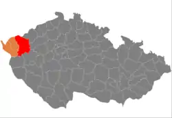 Location in the Karlovy Vary Region within the Czech Republic | |
| Coordinates: 50°14′N 12°59′E | |
| Country | |
| Region | Karlovy Vary |
| Capital | Karlovy Vary |
| Area | |
| • Total | 1,510.73 km2 (583.30 sq mi) |
| Population (2023)[2] | |
| • Total | 114,995 |
| • Density | 76/km2 (200/sq mi) |
| Time zone | UTC+1 (CET) |
| • Summer (DST) | UTC+2 (CEST) |
| Municipalities | 55 |
| * Cities and towns | 15 |
| * Market towns | 0 |
Administrative division
Karlovy Vary District is divided into two administrative districts of municipalities with extended competence: Karlovy Vary and Ostrov.
List of municipalities
Towns are marked in bold:
Abertamy - Andělská Hora - Bečov nad Teplou - Bochov - Boží Dar - Božičany - Bražec - Březová - Černava - Chodov - Chyše - Čichalov - Dalovice - Děpoltovice - Doupovské Hradiště – Hájek - Horní Blatná - Hory - Hroznětín - Jáchymov - Jenišov - Karlovy Vary - Kolová - Krásné Údolí - Krásný Les - Kyselka - Merklín - Mírová - Nejdek - Nová Role - Nové Hamry - Ostrov - Otovice - Otročín - Pernink - Pila - Potůčky - Pšov - Sadov - Šemnice - Smolné Pece - Stanovice - Štědrá - Stráž nad Ohří - Stružná - Teplá - Teplička - Toužim - Útvina - Valeč - Velichov - Verušičky - Vojkovice - Vrbice - Vysoká Pec - Žlutice
Part of the district area belongs to Hradiště Military Training Area.
Geography

Karlovy Vary District borders Germany in the north. The character of the terrain is very diverse, the landscape alternates between mountainous, hilly and slightly undulating. The territory extends into six geomorphological mesoregions: Ore Mountains (north), Doupov Mountains (east), Sokolov Basin (west), Slavkov Forest (west), Teplá Highlands (south) and Rakovník Uplands (small part in the southeast). The highest point of the district and the entire Karlovy Vary Region is the Klínovec Mountain in Jáchymov with an elevation of 1,244 metres (4,081 ft). The lowest point is the river bed of the Ohře in Stráž nad Ohří at 305 m (1,001 ft).
From the total district area of 1,510.7 km2 (583.3 sq mi), agricultural land occupies 534.5 km2 (206.4 sq mi), forests occupy 651.3 km2 (251.5 sq mi), and water area occupies 26.5 km2 (10.2 sq mi). Forests cover 43.1% of the district's area.[1]
The most important river is the Ohře, which flows across the territory from west to northeast. Its longest tributaries within the district are the rivers Teplá and Rolava. The southern part of the district is drained by the Střela. The district is also crossed by the Černá in the north. There are no significant bodies of water. The largest body of water is the Žlutice Reservoir.
There is one protected landscape area, located in the west of the district: Slavkovský les.
Demographics
|
|
| ||||||||||||||||||||||||||||||||||||||||||||||||||||||
| Source: Censuses[3][4] | ||||||||||||||||||||||||||||||||||||||||||||||||||||||||
Economy
The largest employers with headquarters in Karlovy Vary District and at least 500 employees are:[5]
| Economic entity | Location | Number of employees | Main activity |
|---|---|---|---|
| Regional Hospital Karlovy Vary | Karlovy Vary | 2,000–2,499 | Health care |
| Witte Nejdek | Nejdek | 1,500–1,999 | Manufacture of locks and hinges |
| Léčebné lázně Jáchymov | Jáchymov | 500–999 | Health care |
| Mattoni 1873 | Karlovy Vary | 500–999 | Manufacture of beverages |
| Vodárny a kanalizace Karlovy Vary | Karlovy Vary | 500–999 | Water collection, treatment and supply |
| Thun 1794 | Nová Role | 500–999 | Manufacture of porcelain |
| Witte Access Technology | Ostrov | 500–999 | Manufacture of door handles |
Transport
The I/6 road, which is the unfinished section of the D6 motorway from Prague to Karlovy Vary and Cheb (part of the European route E48), passes through the district. The I/20 road (part of the European route E49) leads from Karlovy Vary to Plzeň.
Karlovy Vary Airport is located in the district. It is one of the six public international airports in the country.
Sights
The Red Tower of Death in Ostrov, the mining cultural landscape Jáchymov and the mining cultural landscape Abertamy – Boží Dar – Horní Blatná were designated UNESCO World Heritage Sites in 2019 as parts of the transnational Ore Mountain Mining Region.[6]
The historic city centre of Karlovy Vary with the spa cultural landscape was designated a UNESCO World Heritage Site in 2021 as part of the transnational Great Spa Towns of Europe because of its springs and architectural testimony to the popularity of spa towns in Europe during the 18th through 20th centuries.[7]
The most important monuments in the district, protected as national cultural monuments, are:[8]
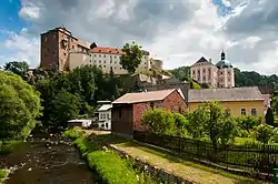
- Bečov nad Teplou Castle
- Reliquary of St. Maurus
- Red Tower of Death in Ostrov
- Císařské lázně spa building in Karlovy Vary
- Church of Saint Mary Magdalene in Karlovy Vary
- Mint in Jáchymov
- Mauritius Mine in Abertamy
- Blatenský water ditch
The best-preserved settlements and landscapes, protected as monument reservations and monument zones, are:[9]
- Karlovy Vary (monument reservation)
- Archaeological site in Karlovy Vary-Tašovice (monument reservation)
- Bečov nad Teplou
- Horní Blatná
- Jáchymov
- Ostrov
- Toužim
- Valeč
- Žlutice
- Kojšovice
- Kosmová
- Abertamy – Boží Dar – Horní Blatná – Mining Landscape
- Jáchymov Mining Landscape
- Bečovsko landscape
- Valečsko landscape
The most visited tourist destinations are the Motýlí dům tropical garden in Karlovy Vary, Bečov nad Teplou castle and chateau, Klínovec observation tower, Becherovka visitor's centre in Karlovy Vary, and botanical garden in Bečov nad Teplou.[10]
Notable people
References
- "Land use (as at 31 December)". Public database. Czech Statistical Office. Retrieved 2023-05-17.
- "Population of Municipalities – 1 January 2023". Czech Statistical Office. 2023-05-23.
- "Historický lexikon obcí České republiky 1869–2011 – Okres Karlovy Vary" (in Czech). Czech Statistical Office. 2015-12-21. pp. 1–2.
- "Population Census 2021: Population by sex". Public Database. Czech Statistical Office. 2021-03-27.
- "Registr ekonomických subjektů". Business Register (in Czech). Czech Statistical Office. Retrieved 2023-02-22.
- "Erzgebirge/Krušnohoří Mining Region". UNESCO. Retrieved 2023-02-22.
- "The Great Spa Towns of Europe". UNESCO. Retrieved 2023-02-22.
- "Výsledky vyhledávání: Národní kulturní památky, okres Karlovy Vary". Ústřední seznam kulturních památek (in Czech). National Heritage Institute. Retrieved 2023-02-22.
- "Výsledky vyhledávání: Památkové rezervace, Památkové zóny, okres Karlovy Vary". Ústřední seznam kulturních památek (in Czech). National Heritage Institute. Retrieved 2023-02-22.
- "Turisté mají v České republice nejraději zoologické zahrady, technické památky, koupání a Pražský hrad" (in Czech). CzechTourism. 2022-06-24. Retrieved 2023-02-21.
External links
- Karlovy Vary District – profile on the Czech Statistical Office website