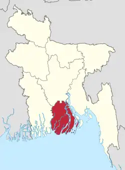
Kawkhali Upazila, Pirojpur
Kawkhali (Bengali: কাউখালী) is an upazila of Pirojpur District in the Division of Barisal, Bangladesh.[1]
Kawkhali
কাউখালী | |
|---|---|
.svg.png.webp) | |
| Coordinates: 22°37.2′N 90°4.2′E | |
| Country | |
| Division | Barisal Division |
| District | Pirojpur District |
| Area | |
| • Total | 79.56 km2 (30.72 sq mi) |
| Population (2011) | |
| • Total | 70,130 |
| • Density | 880/km2 (2,300/sq mi) |
| Time zone | UTC+6 (BST) |
| Website | Official Map of the Kawkhali Upazila |
Geography
Kawkhali is located at 22.6203°N 90.0694°E. It has 13,763 households and a total area of 79.56 km2.
Demographics
According to the 2011 Bangladesh census, Kawkhali Upazila had 16,208 households and a population of 70,115. 14,321 (20.43%) were under 10 years of age. Kawkhali has a literacy rate (age 7 and over) of 64.6%, compared to the national average of 51.8%, and a sex ratio of 1010 females per 1000 males. 9,641 (13.75%) lived in urban areas.[2][3]
According to the 1991 Bangladesh census,[4] Kawkhali had a population of 70,347, of whom 37,391 were aged 18 or older. Males constituted 50.46% of the population, and females 49.54%. Kawkhali had an average literacy rate of 50.4% (7+ years), compared to the national average of 32.4%.[5]
Administration
Kawkhali Upazila is divided into five union parishads: Amrajuri, Chirapara Parshaturia, Kawkhali, Sayna Raghunathpur, and Shial Kati. The union parishads are subdivided into 45 mauzas and 59 villages.[6]
Kawkhali town
Kawkhali is a small town and its communication depends on rivers and roads. It has a launch & steamer station which dates from the British period. The Gabkhan Channel starts from Kawkhali near the village of Ashoa. On it many ships run from Mongla seaport to Dhaka.
References
- Tapan Kumar Roy (2012). "Kawkhali Upazila (Pirojpur District)". In Sirajul Islam and Ahmed A. Jamal (ed.). Banglapedia: National Encyclopedia of Bangladesh (Second ed.). Asiatic Society of Bangladesh.
- "Community Report: Pirojpur" (PDF). Population & Housing Census 2011. Bangladesh Bureau of Statistics. Retrieved 15 August 2018.
- "Bangladesh Population & Housing Census-2011, Zila Report: Pirojpur" (PDF). Bangladesh Bureau of Statistics. p. 18.
- "US Gazetteer files: 2010, 2000, and 1990". United States Census Bureau. 2011-02-12. Archived from the original on 2002-05-27. Retrieved 2011-04-23.
- "Population Census Wing, BBS". Archived from the original on 2005-03-27. Retrieved November 10, 2006.
- "District Statistics 2011: Pirojpur" (PDF). Bangladesh Bureau of Statistics. Archived from the original (PDF) on 13 November 2014. Retrieved 14 July 2014.
