Kayak Point, Washington
Kayak Point is a census-designated place (CDP) located in Snohomish County, Washington, United States. The CDP was newly defined by the United States Census Bureau in 2013.[3] The population was 1,737 as of 2013 estimates.
Kayak Point, Washington | |
|---|---|
 Kayak Point, Washington | |
| Coordinates: 48°08′33″N 122°20′32″W | |
| Country | United States |
| State | Washington |
| County | Snohomish |
| Area | |
| • Total | 5.485 sq mi (14.21 km2) |
| • Land | 5.474 sq mi (14.18 km2) |
| • Water | 0.011 sq mi (0.03 km2) |
| Population (2013)[1] | |
| • Total | 1,737 |
| • Density | 320/sq mi (120/km2) |
| Time zone | Pacific |
| ZIP code | 98292[2] |
| Area code | 360 |
It is home to Kayak Point County Park as well as a golf course.
Geography
Lake Cassidy is located at coordinates 48°08′33″N 122°20′32″W (48.142508, -122.342276).[4]
According to the United States Census Bureau, the CDP has a total area of 5.485 square miles (14.2 km²), of which, 5.474 square miles (14.2 km²) of it is land and 0.011 square miles (0.03 km²) of it (0.20%) is water.
References
- "U.S. Census website". United States Census Bureau. Retrieved 2015-05-24.
- "Kayak Point WA ZIP Code". zipdatamaps.com. 2023. Retrieved June 16, 2023.
- "Geographic Boundary Change Notes". United States Census Bureau. Retrieved 2015-05-24.
- "US Gazetteer files: 2014". United States Census Bureau. Retrieved 2015-05-24.
Municipalities and communities of Snohomish County, Washington, United States | ||
|---|---|---|
| Cities | 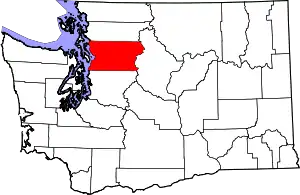 Map of Washington highlighting Snohomish County | |
| Towns | ||
| CDPs |
| |
| Other communities | ||
| Indian reservation | ||
| Military bases | ||
| Ghost town |
| |
| Footnotes | ‡This populated place also has portions in an adjacent county or counties | |
| ||
This article is issued from Wikipedia. The text is licensed under Creative Commons - Attribution - Sharealike. Additional terms may apply for the media files.