Kia Ora, Queensland
Kia Ora is a rural locality in the Gympie Region, Queensland, Australia.[2] In the 2021 census, Kia Ora had a population of 218 people.[3]
| Kia Ora Queensland | |||||||||||||||
|---|---|---|---|---|---|---|---|---|---|---|---|---|---|---|---|
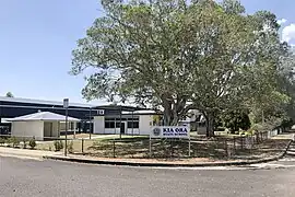 Kia-Ora State School, 2020 | |||||||||||||||
 Kia Ora | |||||||||||||||
| Coordinates | 26.0155°S 152.7658°E | ||||||||||||||
| Population | 218 (SAL 2021)[1] | ||||||||||||||
| Postcode(s) | 4570 | ||||||||||||||
| Area | 22.5 km2 (8.7 sq mi) | ||||||||||||||
| Time zone | AEST (UTC+10:00) | ||||||||||||||
| Location |
| ||||||||||||||
| LGA(s) | Gympie Region | ||||||||||||||
| State electorate(s) | Gympie | ||||||||||||||
| Federal division(s) | Wide Bay | ||||||||||||||
| |||||||||||||||
History

The district takes its name from the Kia-Ora pastoral property operated by the Elliott family. The name comes from the Māori greeting Kia ora.[4]
Kia-Ora Provisional School opened on 18 July 1921 on land donated by the Elliott family. It became a state school in 1927.[4][5][6]
In 1931, the main industries were dairying and forestry.[7]
The Kia Ora Methodist Church opened in September 1938, becoming a Uniting Church folllowing the 1977 amalgamation.[8][9] It was at 2755 Anderleigh Road (26.02878°S 152.77777°E). It closed circa 1990 and was subsequently sold and converted to a house.[10][11]
On 9 December 1950, the Kia Ora Memorial Hall was erected to honour those who served in war..[12]
Demographics
In the 2011 census, Kia Ora had a population of 501 people.[13]
In the 2016 census, Kia Ora had a population of 205 people.[14]
In the 2021 census, Kia Ora had a population of 218 people.[3]
Heritage listings
Kia Ora has the following heritage sites:
Education
Kia-Ora State School is a government primary (Prep-6) school for boys and girls at 2754 Anderleigh Road (26.0284°S 152.7773°E).[17][18] In 2017, the school had an enrolment of 62 students with 4 teachers and 11 non-teaching staff (5 full-time equivalent).[19]
There is no secondary school in Kia Ora. The nearest government secondary schools are Gympie State High School (to Year 12) in Gympie to the south-west and Tin Can Bay State School (to Year 10) in Tin Can Bay to the north-east.[20]
Amenities
Kia Ora Public Memorial Hall is at 2740 Anderleigh Road (26.02733°S 152.77724°E).[21]
References
- Australian Bureau of Statistics (28 June 2022). "Kia Ora (Qld) (Suburb and Locality)". Australian Census 2021 QuickStats. Retrieved 28 June 2022.
- "Kia Ora – locality in Gympie Region (entry 46347)". Queensland Place Names. Queensland Government. Retrieved 11 June 2019.
- Australian Bureau of Statistics (28 June 2022). "Kia Ora (SAL)". 2021 Census QuickStats. Retrieved 28 February 2023.
- "Kia Ora – What's in a name?". Gympie Regional Memories. 29 July 2020. Archived from the original on 31 May 2023. Retrieved 1 October 2023.
- "Opening and closing dates of Queensland Schools". Queensland Government. Retrieved 18 April 2019.
- "Kia Ora SS". Archived from the original on 2 February 2017. Retrieved 30 January 2017.
- "CARAVAN TALES". The Queenslander (Brisbane, Qld. : 1866 - 1939). Brisbane, Qld.: National Library of Australia. 24 September 1931. p. 4. Archived from the original on 1 October 2023. Retrieved 7 May 2014.
- "KIA ORA". The Telegraph. Queensland, Australia. 14 September 1938. p. 12 (CITY FINAL LAST MINUTE NEWS). Archived from the original on 1 October 2023. Retrieved 2 October 2023 – via National Library of Australia.
- "North Coast Methodist Synod". Nambour Chronicle and North Coast Advertiser. Vol. XXXIII, no. 1795. Queensland, Australia. 28 October 1938. p. 4. Archived from the original on 1 October 2023. Retrieved 2 October 2023 – via National Library of Australia.
- "Kia Ora Methodist Church | Kia Ora". Queensland Religious Places Database. Archived from the original on 1 October 2023. Retrieved 1 October 2023.
- "2755 Anderleigh Road, Kia Ora, QLD 4570". Realestate.com.au. Retrieved 2 October 2023.
- "Kia Ora Memorial Hall". Monument Australia. Archived from the original on 7 May 2014. Retrieved 6 May 2014.
- Australian Bureau of Statistics (31 October 2012). "Kia Ora (SSC)". 2011 Census QuickStats. Retrieved 6 May 2014.
- Australian Bureau of Statistics (27 June 2017). "Kia Ora (SSC)". 2016 Census QuickStats. Retrieved 20 October 2018.
- "Kia Ora School". Gympie Regional Council Local Heritage Register. pp. 5–6. Archived from the original on 5 March 2023. Retrieved 2 October 2023.
- "Kia Ora Methodist Church". Gympie Regional Council Local Heritage Register. pp. 197–198. Archived from the original on 5 March 2023. Retrieved 2 October 2023.
- "State and non-state school details". Queensland Government. 9 July 2018. Archived from the original on 21 November 2018. Retrieved 21 November 2018.
- "Kia Ora State School". Kia-Ora State School. 29 November 2020. Archived from the original on 4 May 2013. Retrieved 1 October 2023.
- "ACARA School Profile 2017". Archived from the original on 22 November 2018. Retrieved 22 November 2018.
- "Layers: Locality; Schools and school catchments". Queensland Globe. Queensland Government. Archived from the original on 19 December 2017. Retrieved 1 October 2023.
- "Kia Ora Public Memorial Hall". Gympie Regional Council. Archived from the original on 26 March 2023. Retrieved 1 October 2023.
External links
![]() Media related to Kia Ora, Queensland at Wikimedia Commons
Media related to Kia Ora, Queensland at Wikimedia Commons