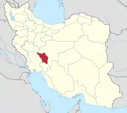
Kiar County
Kiar County (Persian: شهرستان کیار) is in Chaharmahal and Bakhtiari province, Iran. The capital of the county is the city of Shalamzar.[3]
Kiar County
Persian: شهرستان کیار | |
|---|---|
County | |
 Location of Kiar County in Chaharmahal and Bakhtiari province (center, yellow) | |
 Location of Chaharmahal and Bakhtiari province in Iran | |
| Coordinates: 31°56′N 50°55′E[1] | |
| Country | |
| Province | Chaharmahal and Bakhtiari |
| Capital | Shalamzar |
| Districts | Central, Naghan |
| Population (2016)[2] | |
| • Total | 50,976 |
| Time zone | UTC+3:30 (IRST) |
At the 2006 census, the region's population (as parts of Ardal County and Shahrekord County) was 52,360 in 12,608 households.[4] The following census in 2011 counted 58,047 people in 16,298 households, by which time those parts had been separated from their counties to form Kiar County.[5] At the 2016 census, the county's population was 50,976 in 15,548 households, by which time Dastgerd Rural District had been separated from the county to rejoin Shahrekord County.[2]
Administrative divisions
The population history and structural changes of Kiar County's administrative divisions over three consecutive censuses are shown in the following table. The latest census shows two districts, four rural districts, and four cities.[2]
| Administrative Divisions | 2006[4] | 2011[5] | 2016[2] |
|---|---|---|---|
| Central District | 36,988 | 42,540 | 35,015 |
| Dastgerd Rural District1 | 6,090 | ||
| Kiar-e Gharbi Rural District2 | 15,352 | 9,814 | 9,011 |
| Kiar-e Sharqi Rural District2 | 8,540 | 8,356 | 7,699 |
| Dastana (city)2 | 5,199 | 5,143 | |
| Gahru (city)2 | 6,093 | 5,949 | 6,263 |
| Shalamzar (city)2 | 7,003 | 7,132 | 6,899 |
| Naghan District3 | 15,372 | 15,507 | 15,957 |
| Mashayekh Rural District | 7,158 | 7,586 | 7,093 |
| Naghan Rural District | 3,286 | 3,060 | 2,739 |
| Naghan (city) | 4,928 | 4,861 | 6,125 |
| Total | 52,360 | 58,047 | 50,976 |
| 1As a part of Shahrekord County at the 2006 and 2016 censuses 2As a part of Shahrekord County at the 2006 census 3As a part of Ardal County at the 2006 census | |||
References
- OpenStreetMap contributors (2 April 2023). "Kiar County" (Map). OpenStreetMap. Retrieved 2 April 2023.
- "Census of the Islamic Republic of Iran, 1395 (2016)". AMAR (in Persian). The Statistical Center of Iran. p. 14. Archived from the original (Excel) on 24 May 2019. Retrieved 19 December 2022.
- Gitashenasi Province Atlas of Iran
اطلس گیتاشناسی استانهای ایران Archived 2007-05-22 at the Wayback Machine - "Census of the Islamic Republic of Iran, 1385 (2006)". AMAR (in Persian). The Statistical Center of Iran. p. 14. Archived from the original (Excel) on 20 September 2011. Retrieved 25 September 2022.
- "Census of the Islamic Republic of Iran, 1390 (2011)" (Excel). Iran Data Portal (in Persian). The Statistical Center of Iran. p. 14. Retrieved 19 December 2022.
