Korozluky
Korozluky (German: Kolosoruk) is a municipality and village in Most District in the Ústí nad Labem Region of the Czech Republic. It has about 200 inhabitants.
Korozluky | |
|---|---|
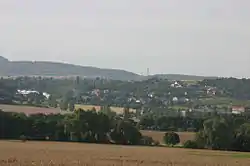 View from the north | |
 Flag  Coat of arms | |
 Korozluky Location in the Czech Republic | |
| Coordinates: 50°28′43″N 13°43′23″E | |
| Country | |
| Region | Ústí nad Labem |
| District | Most |
| First mentioned | 1325 |
| Area | |
| • Total | 6.38 km2 (2.46 sq mi) |
| Elevation | 235 m (771 ft) |
| Population (2023-01-01)[1] | |
| • Total | 230 |
| • Density | 36/km2 (93/sq mi) |
| Time zone | UTC+1 (CET) |
| • Summer (DST) | UTC+2 (CEST) |
| Postal code | 434 01 |
| Website | www |
Korozluky lies approximately 7 kilometres (4 mi) south-east of Most, 31 km (19 mi) south-west of Ústí nad Labem, and 66 km (41 mi) north-west of Prague.
Administrative parts
The village of Sedlec is an administrative part of Korozluky.
This article is issued from Wikipedia. The text is licensed under Creative Commons - Attribution - Sharealike. Additional terms may apply for the media files.