Lom (Most District)
Lom (German: Bruch) is a town in Most District in the Ústí nad Labem Region of the Czech Republic. It has about 3,700 inhabitants.
Lom | |
|---|---|
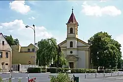
 Church of the Sacred Heart at the town square | |
 Flag  Coat of arms | |
 Lom Location in the Czech Republic | |
| Coordinates: 50°36′2″N 13°39′22″E | |
| Country | |
| Region | Ústí nad Labem |
| District | Most |
| First mentioned | 1341 |
| Government | |
| • Mayor | Vladimír Urban |
| Area | |
| • Total | 16.80 km2 (6.49 sq mi) |
| Elevation | 294 m (965 ft) |
| Population (2023-01-01)[1] | |
| • Total | 3,701 |
| • Density | 220/km2 (570/sq mi) |
| Time zone | UTC+1 (CET) |
| • Summer (DST) | UTC+2 (CEST) |
| Postal code | 435 11 |
| Website | www |
Administrative parts
The village of Loučná is an administrative part of Lom.
Geography
Lom is located about 9 km (6 mi) north of Most. The southern part of the municipal territory with the built-up area lies in the Most Basin, the northern part lies in the Ore Mountains. The highest point is the mountain Loučná at 956 m (3,136 ft) above sea level.
History
The settlement of Lom was established on the road through the Ore Mountains at the end of the 12th century. Until the 17th century, it was focused on agriculture, since then its history is closely connected with mining of iron ore and lignite.[2]
In 1902, Lom became a market town, and in 1938, it became a town. Until 1989, the town was threatened with liquidation due to coal mining. The town gained a new perspective of survival and further development after 1989 with the decision to create a so-called protective pillar on the town's border, to limit and finally to stop further coal mining in this locality.[2]
Sights
.jpg.webp)
The main landmark of Lom is the Church of the Sacred Heart. This Neo-Renaissance building dates from 1888.[3]
Other monuments and sights in Lom include a plague column with a pedestal and a relief of St. George from the 15th century, the Chapel of the Holy Trinity from the 1880s, the original mining colony from the end of the 19th century, and a conciliation cross with a crossbow relief from the 13th century.[2]
References
- "Population of Municipalities – 1 January 2023". Czech Statistical Office. 2023-05-23.
- "Historie" (in Czech). Město Lom. Retrieved 2021-07-09.
- "Kostel Nejsvětějšího Srdce Páně" (in Czech). National Heritage Institute. Retrieved 2023-06-01.