Korsis Island
Korsis Island (Bulgarian: остров Корсис, romanized: ostrov Korsis, IPA: [ˈɔstrof ˈkɔrsis]) is the rocky island lying 150 m off the northwest coast of Snow Island in the South Shetland Islands, Antarctica. It extends 300 m in southeast-northwest direction and 180 m wide. The feature is named after the Bulgarian military commander Korsis, 9th century.
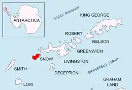
Location of Snow Island in the South Shetland Islands

Topographic map of Livingston Island, Greenwich, Robert, Snow and Smith Islands
Location
Korsis Island is located at 62°44′49.5″S 61°29′44″W, which is 1750 m northeast of Byewater Point, 760 m east-northeast of Gergini Reef and 2.93 km southwest of Bizone Rock. Bulgarian mapping in 2009.
Maps
- L.L. Ivanov. Antarctica: Livingston Island and Greenwich, Robert, Snow and Smith Islands. Scale 1:120000 topographic map. Troyan: Manfred Wörner Foundation, 2009.
- Antarctic Digital Database (ADD). Scale 1:250000 topographic map of Antarctica. Scientific Committee on Antarctic Research (SCAR). Since 1993, regularly upgraded and updated
References
- Bulgarian Antarctic Gazetteer. Antarctic Place-names Commission. (details in Bulgarian, basic data in English)
- Korsis Island. SCAR Composite Gazetteer of Antarctica
External links
- Korsis Island. Copernix satellite image
This article includes information from the Antarctic Place-names Commission of Bulgaria which is used with permission.
This article is issued from Wikipedia. The text is licensed under Creative Commons - Attribution - Sharealike. Additional terms may apply for the media files.