Lügde
Lügde [ˈlʏçtʰə] ⓘ is a town in the Lippe district of North Rhine-Westphalia, Germany, with c. 9,800 inhabitants (2013).
Lügde | |
|---|---|
.jpg.webp) | |
 Coat of arms | |
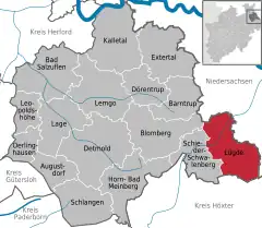
Location of Lügde within Lippe district  | |
 Lügde  Lügde | |
| Coordinates: 51°57′00″N 09°15′00″E | |
| Country | Germany |
| State | North Rhine-Westphalia |
| Admin. region | Detmold |
| District | Lippe |
| Government | |
| • Mayor (2020–25) | Torben Blome[1] (SPD) |
| Area | |
| • Total | 88.64 km2 (34.22 sq mi) |
| Elevation | 105 m (344 ft) |
| Population (2021-12-31)[2] | |
| • Total | 9,244 |
| • Density | 100/km2 (270/sq mi) |
| Time zone | UTC+01:00 (CET) |
| • Summer (DST) | UTC+02:00 (CEST) |
| Postal codes | 32668–32676 |
| Dialling codes | 05281, 05283 |
| Vehicle registration | LIP |
| Website | luegde.de |
The first written issue of Lügde appears in 784, in the annals of the Frankish Empire, when Charlemagne visited the village during the Saxon Wars. During these wars Charlemagne celebrated his first Christmas in Saxony in Lügde, and the site then became the location of the first church to be built in Saxony. The gothic church was rebuilt in the 12th century and it is still standing today. The church is known as the Kirche St. Kilian.
Climate
| Climate data for Lügde (1991–2020 normals) | |||||||||||||
|---|---|---|---|---|---|---|---|---|---|---|---|---|---|
| Month | Jan | Feb | Mar | Apr | May | Jun | Jul | Aug | Sep | Oct | Nov | Dec | Year |
| Average high °C (°F) | 3.1 (37.6) |
4.1 (39.4) |
8.5 (47.3) |
13.9 (57.0) |
17.2 (63.0) |
20.7 (69.3) |
22.8 (73.0) |
22.5 (72.5) |
18.5 (65.3) |
13.0 (55.4) |
7.7 (45.9) |
4.2 (39.6) |
13.1 (55.6) |
| Daily mean °C (°F) | 0.9 (33.6) |
1.4 (34.5) |
4.6 (40.3) |
8.9 (48.0) |
12.3 (54.1) |
15.5 (59.9) |
17.4 (63.3) |
17.1 (62.8) |
13.5 (56.3) |
9.5 (49.1) |
5.4 (41.7) |
2.1 (35.8) |
9.2 (48.6) |
| Average low °C (°F) | −1.5 (29.3) |
−1.5 (29.3) |
0.7 (33.3) |
3.6 (38.5) |
6.8 (44.2) |
10.3 (50.5) |
12.0 (53.6) |
12.1 (53.8) |
9.0 (48.2) |
6.1 (43.0) |
2.9 (37.2) |
−0.1 (31.8) |
5.2 (41.4) |
| Average precipitation mm (inches) | 82.3 (3.24) |
56.9 (2.24) |
53.5 (2.11) |
38.0 (1.50) |
69.9 (2.75) |
72.9 (2.87) |
83.9 (3.30) |
83.3 (3.28) |
62.3 (2.45) |
69.7 (2.74) |
66.1 (2.60) |
73.8 (2.91) |
819.1 (32.25) |
| Average precipitation days (≥ 1.0 mm) | 19.4 | 16.3 | 15.9 | 12.2 | 15.2 | 14.5 | 16.6 | 16.5 | 14.3 | 16.7 | 17.9 | 20.5 | 198.2 |
| Average relative humidity (%) | 88.0 | 84.5 | 78.6 | 71.8 | 74.6 | 76.5 | 74.9 | 77.0 | 82.1 | 86.8 | 89.7 | 89.6 | 81.2 |
| Mean monthly sunshine hours | 40.2 | 68.2 | 121.6 | 180.9 | 194.0 | 204.6 | 209.4 | 184.9 | 150.2 | 94.3 | 45.8 | 33.3 | 1,498.1 |
| Source: World Meteorological Organisation[3] | |||||||||||||
References
- Wahlergebnisse in NRW Kommunalwahlen 2020, Land Nordrhein-Westfalen, accessed 21 June 2021.
- "Bevölkerung der Gemeinden Nordrhein-Westfalens am 31. Dezember 2021" (in German). Landesbetrieb Information und Technik NRW. Retrieved 20 June 2022.
- "World Meteorological Organization Climate Normals for 1991–2020". World Meteorological Organization Climatological Standard Normals (1991–2020). National Oceanic and Atmospheric Administration. Archived from the original on 12 October 2023. Retrieved 13 October 2023.
This article is issued from Wikipedia. The text is licensed under Creative Commons - Attribution - Sharealike. Additional terms may apply for the media files.