L'Hôpital-Saint-Blaise
L'Hôpital-Saint-Blaise (French pronunciation: [lopital sɛ̃ blɛz]; Basque: Ospitalepea)[3] is a commune in the Pyrénées-Atlantiques département in south-western France.[4]
L'Hôpital-Saint-Blaise
Ospitalepea | |
|---|---|
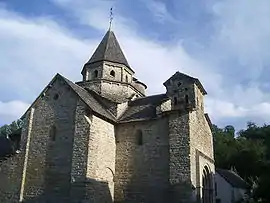 12th-century Romanesque church | |
Location of L'Hôpital-Saint-Blaise | |
 L'Hôpital-Saint-Blaise  L'Hôpital-Saint-Blaise | |
| Coordinates: 43°15′09″N 0°46′03″W | |
| Country | France |
| Region | Nouvelle-Aquitaine |
| Department | Pyrénées-Atlantiques |
| Arrondissement | Oloron-Sainte-Marie |
| Canton | Montagne Basque |
| Intercommunality | CA Pays Basque |
| Government | |
| • Mayor (2020–2026) | Dominique Uthurralt[1] |
| Area 1 | 2.11 km2 (0.81 sq mi) |
| Population | 59 |
| • Density | 28/km2 (72/sq mi) |
| Time zone | UTC+01:00 (CET) |
| • Summer (DST) | UTC+02:00 (CEST) |
| INSEE/Postal code | 64264 /64130 |
| Elevation | 147–254 m (482–833 ft) (avg. 159 m or 522 ft) |
| 1 French Land Register data, which excludes lakes, ponds, glaciers > 1 km2 (0.386 sq mi or 247 acres) and river estuaries. | |
It is located in the historical province of Soule.[3]
Sights
The 12th-century Romanesque church of L'Hôpital-Saint-Blaise has been listed as a UNESCO World Heritage Site as part of the World Heritage Sites of the Routes of Santiago de Compostela in France.
References
- "Répertoire national des élus: les maires" (in French). data.gouv.fr, Plateforme ouverte des données publiques françaises. 13 September 2022.
- "Populations légales 2020". The National Institute of Statistics and Economic Studies. 29 December 2022.
- OSPITALEPEA, Auñamendi Eusko Entziklopedia (in Spanish)
- INSEE commune file
Wikimedia Commons has media related to L'Hôpital-Saint-Blaise.

This article is issued from Wikipedia. The text is licensed under Creative Commons - Attribution - Sharealike. Additional terms may apply for the media files.