Leeuwin, Western Australia
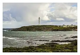
Leeuwin is a rural locality of the Shire of Augusta–Margaret River in the South West region of Western Australia. The locality is surrounded by the Indian Ocean on three sides. Cape Leeuwin and the Cape Leeuwin Lighthouse are located within the locality of Leeuwin, being its southern-most point.[2][3]
| Leeuwin Western Australia | |||||||||||||||
|---|---|---|---|---|---|---|---|---|---|---|---|---|---|---|---|
 Cape Leeuwin and Lighthouse in September 2017 | |||||||||||||||
| Coordinates | 34.34°S 115.14°E | ||||||||||||||
| Population | 4 (SAL 2021)[1] | ||||||||||||||
| Postcode(s) | 6290 | ||||||||||||||
| Area | 21.8 km2 (8.4 sq mi) | ||||||||||||||
| Location | |||||||||||||||
| LGA(s) | Shire of Augusta–Margaret River | ||||||||||||||
| State electorate(s) | Warren-Blackwood | ||||||||||||||
| Federal division(s) | Forrest | ||||||||||||||
| |||||||||||||||
Most of the Shire of Augusta–Margaret River and the locality of Leeuwin are located on the traditional land of the Wardandi people of the Noongar nation.[4][5][6]
The locality is home to a number of state heritage-listed places, the Cape Leeuwin Lighthouse, the Cape Leeuwin water wheel and the HMAS Nizam memorial.[7]
References
- Australian Bureau of Statistics (28 June 2022). "Leeuwin (Suburb and Locality)". Australian Census 2021 QuickStats. Retrieved 28 June 2022.
- "SLIP Map". maps.slip.wa.gov.au. Landgate. Retrieved 13 August 2023.
- "NationalMap". nationalmap.gov.au. Geoscience Australia. Retrieved 13 August 2023.
- "Wardandi". www.boodjar.sis.uwa.edu.au. University of Western Australia. Retrieved 13 August 2023.
- "Wardandi (WA)". www.samuseum.sa.gov.au. South Australian Museum. Retrieved 13 August 2023.
- "Map of Indigenous Australia". aiatsis.gov.au. Australian Institute of Aboriginal and Torres Strait Islander Studies. Retrieved 13 August 2023.
- "Leeuwin". inherit.stateheritage.wa.gov.au. Heritage Council of Western Australia. Retrieved 13 August 2023.
This article is issued from Wikipedia. The text is licensed under Creative Commons - Attribution - Sharealike. Additional terms may apply for the media files.