Yornup, Western Australia
Yornup is a small town in the South West region of Western Australia, situated between Bridgetown and Manjimup on the South Western Highway.
| Yornup Western Australia | |
|---|---|
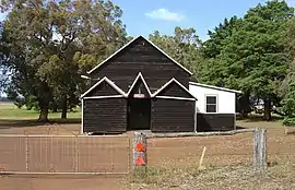
 Yornup Town Hall (Est 1913) | |
 Yornup | |
| Coordinates | 34.056°S 116.17°E |
| Population | 94 (SAL 2021)[1] |
| Established | 1889 |
| Postcode(s) | 6256 |
| Area | 142.2 km2 (54.9 sq mi) |
| Location |
|
| LGA(s) | Shire of Bridgetown-Greenbushes |
| State electorate(s) | Warren-Blackwood |
| Federal division(s) | O'Connor |
Yornup's name is of Noongar origin. It was primarily a milling settlement, and Greenacres Mill continues to this day. A timber company, Lewis and Reid, built a mill in town that was sold in 1923 to Bunning Brothers who upgraded the mill in 1935 and continued to operate until 1951 when the Donnelly River mill commenced operations.[2]
A railway line between the Donnelly Mill and Yornup was built in 1948 and remained in use until the last steam train was retired in 1970.[3]
At one point, Yornup had a school, post office, hall and stores; only the hall remains today, used for community dances. The school was relocated to the rear of 144 Hampton Street, Bridgetown, in March 1996 in anticipation of the construction of a heritage precinct which never eventuated. A large Western Power substation is located in the town, and an industrial estate is proposed for the area.
References
- Australian Bureau of Statistics (28 June 2022). "Yornup (Suburb and Locality)". Australian Census 2021 QuickStats. Retrieved 28 June 2022.
- "Register of Heritage Places - Assessment Documentation" (PDF). 1991. Retrieved 7 November 2010.
- "Morowa Historical Society - Ghosttowns of Western Australia" (PDF). 2000. Retrieved 7 November 2010.
External links
- Tales from times past, ABC South West, 5 July 2004