Liptó County
Liptó County (Hungarian: Liptó vármegye, Latin: Comitatus Liptoviensis, Slovak: Liptovská župa, German: Komitat Liptau, Polish: Komitat Liptów) was an administrative county (comitatus) of the Kingdom of Hungary. Its territory is now in northern Slovakia.
| Liptó County | |
|---|---|
| County of the Kingdom of Hungary | |
| 15th century–1920 | |
 Coat of arms
| |
 | |
| Capital | Liptószentmiklós |
| Area | |
| • Coordinates | 49°5′N 19°37′E |
• 1910 | 2,246 km2 (867 sq mi) |
| Population | |
• 1910 | 86900 |
| History | |
| History | |
• Established | 15th century |
• Treaty of Trianon | 4 June 1920 |
| Today part of | Slovakia |
| Liptovský Mikuláš is the current name of the capital. | |
Geography
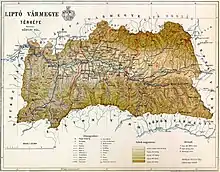

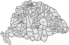
Liptó county shared borders with the Austrian land Galicia and the Hungarian counties Árva, Turóc, Zólyom, Gömör-Kishont and Szepes. The county's territory was situated along the upper Vág (present-day Váh) river between the High Tatras and the Low Tatras. Its area was 2,247 km2 around 1910.
Today, the territory of the former Liptó County largely corresponds to the Ružomberok District and Liptovský Mikuláš District in northern Slovakia. Three villages (Liptovská Teplička, Štrba and Štrbské Pleso) are now in the Poprad District.
Capitals
The capitals of the county were the Liptó Castle, later Németlipcse (present-day Partizánska Ľupča), and since 1677 the capital was Liptószentmiklós (present-day Liptovský Mikuláš).
History
Liptó county as a Hungarian comitatus arose before the 15th century. At various points throughout history the county was ruled by Voivodes or Counts from the Rosenberg, Csák and Benyovszky families. In the aftermath of World War I, the area became part of newly formed Czechoslovakia, as recognized by the concerned states in 1920 by the Treaty of Trianon.
Demographics
| Census | Total | Slovak | Hungarian | German | Other or unknown |
|---|---|---|---|---|---|
| 1880[1] | 74,758 | 67,554 (93.67%) | 1,438 (1.99%) | 2,775 (3.85%) | 353 (0.49%) |
| 1890[2] | 76,850 | 72,067 (93.78%) | 1,771 (2.30%) | 2,568 (3.34%) | 444 (0.58%) |
| 1900[3] | 82,159 | 75,938 (92.43%) | 2,708 (3.30%) | 2,475 (3.01%) | 1,038 (1.26%) |
| 1910[4] | 86,906 | 78,098 (89.86%) | 4,365 (5.02%) | 2,591 (2.98%) | 1,852 (2.13%) |
| Census | Total | Roman Catholic | Lutheran | Jewish | Other or unknown |
|---|---|---|---|---|---|
| 1880 | 74,758 | 38,601 (51.63%) | 32,735 (43.79%) | 3,349 (4.48%) | 73 (0.10%) |
| 1890 | 76,850 | 40,149 (52.24%) | 33,408 (43.47%) | 3,137 (4.08%) | 156 (0.20%) |
| 1900 | 82,159 | 43,979 (53.53%) | 34,953 (42.54%) | 3,092 (3.76%) | 135 (0.16%) |
| 1910 | 86,906 | 47,772 (54.97%) | 35,169 (40.47%) | 3,237 (3.72%) | 728 (0.84%) |
Subdivisions
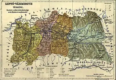
In the early 20th century, the subdivisions of Liptó County were:
| Districts (járás) | |
|---|---|
| District | Capital |
| Liptószentmiklós | Liptószentmiklós (now Liptovský Mikuláš) |
| Liptóújvár | Liptóújvár (now Liptovský Hrádok) |
| Németlipcse | Németlipcse (now Partizánska Ľupča) |
| Rózsahegy | Rózsahegy (now Ružomberok) |
| Urban districts (rendezett tanácsú város) | |
| Rózsahegy (now Ružomberok) | |
Notes
- Only linguistic communities > 1% are displayed.
- Only religious communities > 1% are displayed.
References
- "Az 1881. év elején végrehajtott népszámlálás főbb eredményei megyék és községek szerint rendezve, II. kötet (1882)". library.hungaricana.hu. Retrieved 28 September 2021.
- "A Magyar Korona országainak helységnévtára (1892)". library.hungaricana.hu. Retrieved 29 September 2021.
- "A MAGYAR KORONA ORSZÁGAINAK 1900". library.hungaricana.hu. Retrieved 29 September 2021.
- "KlimoTheca :: Könyvtár". Kt.lib.pte.hu. Retrieved 29 September 2021.
