List of listed buildings in Bothwell, South Lanarkshire
This is a list of listed buildings in the parish of Bothwell (also including Uddingston) in South Lanarkshire, Scotland.
List
| Name | Location | Date Listed | Grid Ref. [note 1] | Geo-coordinates | Notes | LB Number [note 2] | Image |
|---|---|---|---|---|---|---|---|
| Bothwell, 29 Hamilton Road/ 1 Old Mill Road, Including Gatepiers And Boundary Walls | 55°48′00″N 4°03′53″W | Category B | 45074 |  Upload Photo | |||
| Bothwell, 6 Manse Avenue | 55°48′21″N 4°04′14″W | Category C(S) | 45078 | Upload Photo | |||
| Bothwell, 4 And 4A Mill Road, Including Gatepiers And Boundary Walls | 55°48′05″N 4°04′17″W | Category B | 45084 | Upload Photo | |||
| Uddingston, 20 Douglas Gardens, Including Gatepiers, Boundary Walls And Summerhouse | 55°48′57″N 4°04′39″W | Category B | 45097 | Upload Photo | |||
| Uddingston, 1-9 Old Glasgow Road, (Odd Nos), (Incorporating Police Station) Including Gatepiers, Boundary Walls And Railings | 55°49′02″N 4°04′56″W | Category C(S) | 45103 | Upload Photo | |||
| Uddingston, Watson Street, Muiredge Primary School, Including Boundary Walls, Gatepiers, Railings And Headmaster's House | 55°49′14″N 4°04′36″W | Category B | 45105 | Upload Photo | |||
| Uddingston, 2, 6 And 8 Old Glasgow Road | 55°49′06″N 4°04′57″W | Category C(S) | 6622 | Upload Photo | |||
| Bothwell, Main Street, St Bride's Collegiate Church, (Church Of Scotland), Including Graveyard, Boundary Walls, Gatepiers And Gates | 55°48′12″N 4°04′03″W | Category A | 5134 | 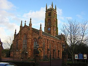
| |||
| Bothwell, Bothwell Bridge | 55°47′45″N 4°03′29″W | Category A | 5138 | 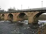
| |||
| Bothwell, Blantyre Mill Road, Elmwood Lodge | 55°48′10″N 4°04′28″W | Category C(S) | 5144 | Upload Photo | |||
| Uddingston, 64-66 Old Glasgow Road, (Even Nos), Including Outbuilding | 55°49′12″N 4°05′09″W | Category B | 5148 | Upload Photo | |||
| Uddingston, Greyfriars Road, Greyfriars Including Gatepiers, Quadrant Walls And Walled Garden | 55°49′57″N 4°06′29″W | Category B | 5150 | Upload Photo | |||
| Bothwell, 13A And 13B Blantyre Mill Road Including Gatepiers And Boundary Walls | 55°48′08″N 4°04′19″W | Category C(S) | 45071 | Upload Photo | |||
| Bothwell, 27 Hamilton Road, The Cricklewood, Public House, Including Boundary Walls | 55°47′59″N 4°03′52″W | Category C(S) | 45073 | Upload Photo | |||
| Bothwell, 6 Orchard Avenue, (Formerly 8 Hamilton Road), Including Gatepiers And Boundary Walls | 55°47′57″N 4°03′47″W | Category C(S) | 45076 | Upload Photo | |||
| Uddingston, 21 Glasgow Road, Including Gatepiers And Boundary Walls And Outbuilding To Rear | 55°49′37″N 4°05′21″W | Category C(S) | 45099 | Upload Photo | |||
| Bothwell, Old Bothwell Road, Covenanters Memorial Including Boundary Walls And Railings | 55°47′48″N 4°03′30″W | Category B | 5139 | 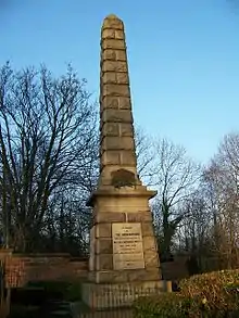
| |||
| Bothwell, Hamilton Road, Old Bothwell Primary School, Including Detached Dining Hall, Gatepiers, Boundary Walls And Railings | 55°48′07″N 4°03′54″W | Category B | 5154 | Upload Photo | |||
| Bothwell, 4 Hamilton Road, Including Boundary Walls | 55°47′56″N 4°03′44″W | Category C(S) | 45075 | Upload Photo | |||
| Bothwell, 46 Main Street, St Bride's Church Lodge | 55°48′12″N 4°04′07″W | Category B | 45081 | Upload Photo | |||
| Bothwell, 28 Silverwells Crescent, Douglas Lodge, Including Boundary Walls And Gatepiers | 55°47′58″N 4°04′22″W | Category C(S) | 45090 | Upload Photo | |||
| Uddingston, 2 Holmwood Avenue Including Gatepiers And Boundary Walls And Outbuilding | 55°49′30″N 4°04′54″W | Category C(S) | 45100 | Upload Photo | |||
| Uddingston, 7-25 (Odd Nos), Main Street And 4 Bellshill Road, Royal Buildings | 55°49′05″N 4°04′56″W | Category B | 6621 | Upload Photo | |||
| Bothwell, 24 Fairfield Place, Fairfield House, Including Boundary Walls And Gatepiers, Garden Walls, Gatepiers And Gates | 55°48′14″N 4°03′46″W | Category B | 5142 | Upload Photo | |||
| Bothwell, 2 Main Street, Library, Formerly The Donald Institute, Including Boundary Walls, Gatepiers, Gates And Railings | 55°48′08″N 4°03′57″W | Category C(S) | 5155 | Upload Photo | |||
| Bothwell, 15-17 (Odd Nos) Langside Road, Including Boundary Wall And Gatepiers | 55°48′00″N 4°03′45″W | Category C(S) | 45077 | Upload Photo | |||
| Bothwell, 11 Silverwells Crescent, Hollybank, Including Boundary Walls And Gatepiers | 55°48′01″N 4°04′00″W | Category C(S) | 45087 | Upload Photo | |||
| Uddingston Bowling And Tennis Club, Central Block Of Clubhouse Only | 55°49′07″N 4°05′06″W | Category C(S) | 45095 | Upload Photo | |||
| Uddingston, Bothwell Road, Bothwell Castle Gatehouse Including Screen Walls, Quadrant Walls And Piers | 55°48′46″N 4°04′47″W | Category B | 5137 | Upload Photo | |||
| Bothwell, Green Street, Sweethope House | 55°48′16″N 4°03′46″W | Category B | 5141 | Upload Photo | |||
| Uddingston, 60 Old Glasgow Road, Easter Cottage, Including Boundary Walls | 55°49′11″N 4°05′06″W | Category C(S) | 5146 | Upload Photo | |||
| Uddingston, 62 Old Glasgow Road, Easter Farm, Including Flanking Outbuildings, Gatepiers, Boundary Walls And Railings | 55°49′12″N 4°05′07″W | Category B | 5147 | Upload Photo | |||
| Bothwell, Laighlands Road, Criagievar And Gleneden Including Entrance Lampstands | 55°48′09″N 4°03′40″W | Category A | 5151 | Upload Photo | |||
| Bothwell 73-77 Main Street (Odd Nos), Clydesdale Bank | 55°48′11″N 4°04′08″W | Category B | 45079 | Upload Photo | |||
| Bothwell, 2 Mill Road, Including Gatepiers And Boundary Walls | 55°48′07″N 4°04′17″W | Category C(S) | 45083 | Upload Photo | |||
| Bothwell, 3 And 3A Silverwells Crescent, Including Gatepiers And Boundary Walls | 55°48′01″N 4°03′55″W | Category C(S) | 45086 | Upload Photo | |||
| Bothwell, 18-20 (Even Nos), Silverwells Crescent, Haxton House, Including Boundary Walls | 55°47′59″N 4°04′10″W | Category C(S) | 45088 | Upload Photo | |||
| Uddingston, Blantyre Farm Road And Old Glasgow Road, Haughhead Bridge Tollhouse, Clydeneuk Cottage | 55°49′46″N 4°05′57″W | Category C(S) | 45093 | Upload Photo | |||
| Uddingston, 15 Glasgow Road, Including Gatepiers, Boundary Walls, Gates And Railings | 55°49′35″N 4°05′19″W | Category C(S) | 45098 | Upload Photo | |||
| Uddingston, 1 Main Street, Uddingston Library Including Boundary Walls Railings And Gates | 55°49′03″N 4°04′55″W | Category C(S) | 45101 | Upload Photo | |||
| Uddingston, Old Glasgow Road And Castle Avenue, Uddingston Old Parish Church, (Church Of Scotland), Including Hall, Boundary Walls, Gatepiers And Gates | 55°49′04″N 4°04′59″W | Category B | 45102 | 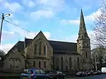
| |||
| Bothwell, Bothwell Parish Church, Joanna Baillie Monument | 55°48′11″N 4°04′06″W | Category A | 5135 |
| |||
| Bothwell, Bothwell Castle | 55°48′34″N 4°05′40″W | Category A | 5136 | 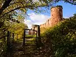
| |||
| Bothwell, The Glebe, Sweethope Farm, Formerly Back Sweethope | 55°48′22″N 4°03′52″W | Category B | 5152 | Upload Photo | |||
| Uddingston, Uddingston Viaduct | 55°49′24″N 4°05′45″W | Category A | 5153 | 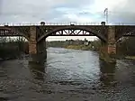
| |||
| Bothwell, Blantyre Mill Road, Entrance To Elmwood Mansion, Including Gate Piers, Gates, Boundary Walls And Railings | 55°48′09″N 4°04′28″W | Category B | 88 | Upload Photo | |||
| Uddingston, 3 Glasgow Road, Primrose Bank, Including Gatepiers And Boundary Walls | 55°49′28″N 4°05′13″W | Category C(S) | 45091 | Upload Photo | |||
| Uddingston, Blantyre Farm Road, Haughhead Bridge | 55°49′46″N 4°06′03″W | Category B | 45092 | .jpg.webp)
| |||
| Uddingston, Old Mill Road, The Rowan Tree Inn | 55°49′11″N 4°04′51″W | Category B | 6453 | Upload Photo | |||
| Bothwell, 1-3 Main Street (Odd Nos), Camphill Vaults Public House | 55°48′07″N 4°03′58″W | Category C(S) | 6375 | Upload Photo | |||
| Bothwell Castle Park, The Poultry | 55°48′52″N 4°05′25″W | Category B | 5149 | Upload Photo | |||
| Bothwell, Main Street, Russell Memorial Hall, Including Gatepiers, Boundary Walls And Railings | 55°48′13″N 4°04′06″W | Category C(S) | 47151 | Upload Photo | |||
| Bothwell, 60 Main Street, Bothwell Evangelical Church, Including Boundary Walls, Gatepiers, Gates And Railings | 55°48′17″N 4°04′12″W | Category B | 45082 | Upload Photo | |||
| Bothwell, 3 Orchard Avenue, Anchorage House, Including Gatepiers | 55°47′59″N 4°03′47″W | Category C(S) | 45085 | Upload Photo | |||
| Uddingston, Bowling And Tennis Club, Bowling Pavilion | 55°49′08″N 4°05′04″W | Category C(S) | 45094 | Upload Photo | |||
| Uddingston, Church Street And Main Street, Park United Free Church Of Scotland, Including Adjoining Church Hall Boundary Walls, Gatepiers And Railings | 55°49′12″N 4°04′59″W | Category B | 45096 | Upload Photo | |||
| Bothwell, 7 Fairyknowe Gardens, Mansfield, Including Gatepiers, Boundary Walls And Outbuilding | 55°48′14″N 4°03′58″W | Category B | 45072 | Upload Photo | |||
| Bothwell, 8-10 (Even Nos), Main Street, Including Gatepiers And Boundary Walls | 55°48′09″N 4°04′00″W | Category C(S) | 45080 | Upload Photo | |||
| Bothwell, 26 Silverwells Crescent, Including Gatepiers, Gates And Boundary Walls | 55°47′59″N 4°04′20″W | Category C(S) | 45089 | Upload Photo | |||
| Uddingston, Station Road, Uddingston Grammar School, (Original Core Only), Including Gatepiers, Boundary Walls And Railings | 55°49′23″N 4°05′12″W | Category C(S) | 45104 | Upload Photo | |||
| Bothwell, Bothwell Park Road, Bothwell Park House | 55°48′33″N 4°03′22″W | Category B | 5140 | Upload Photo | |||
| Bothwell, 20 And 22 Green Street, Greenbank | 55°48′12″N 4°03′49″W | Category B | 5143 | Upload Photo | |||
| Bothwell, 1-8 (Inclusive Nos) Blantyre Mill Road, Elmwood Mansion | 55°48′11″N 4°04′25″W | Category B | 5145 | Upload Photo |
Key
The scheme for classifying buildings in Scotland is:
- Category A: "buildings of national or international importance, either architectural or historic; or fine, little-altered examples of some particular period, style or building type."[1]
- Category B: "buildings of regional or more than local importance; or major examples of some particular period, style or building type, which may have been altered."[1]
- Category C: "buildings of local importance; lesser examples of any period, style, or building type, as originally constructed or moderately altered; and simple traditional buildings which group well with other listed buildings."[1]
In March 2016 there were 47,288 listed buildings in Scotland. Of these, 8% were Category A, and 50% were Category B, with the remaining 42% being Category C.[2]
Notes
- Sometimes known as OSGB36, the grid reference (where provided) is based on the British national grid reference system used by the Ordnance Survey.
• "Guide to National Grid". Ordnance Survey. Retrieved 12 December 2007.
• "Get-a-map". Ordnance Survey. Retrieved 17 December 2007. - Historic Environment Scotland assign a unique alphanumeric identifier to each designated site in Scotland, for listed buildings this always begins with "LB", for example "LB12345".
References
- All entries, addresses and coordinates are based on data from Historic Scotland. This data falls under the Open Government Licence
External links
- Listed Buildings in Bothwell and Uddingston Ward, South Lanarkshire at British Listed Buildings
- "What is Listing?". Historic Environment Scotland. Retrieved 29 May 2018.
- Scotland's Historic Environment Audit 2016 (PDF). Historic Environment Scotland and the Built Environment Forum Scotland. pp. 15–16. Retrieved 29 May 2018.
This article is issued from Wikipedia. The text is licensed under Creative Commons - Attribution - Sharealike. Additional terms may apply for the media files.