List of listed buildings in Dalserf, South Lanarkshire
List
| Name | Location | Date Listed | Grid Ref. [note 1] | Geo-coordinates | Notes | LB Number [note 2] | Image |
|---|---|---|---|---|---|---|---|
| Larkhall, Church Street, St Machan's Church, Church Of Scotland, Including Hall, War Memorial, Boundary Walls, Gatepiers, Railings And Gates | 55°44′14″N 3°58′17″W | Category B | 45113 |  Upload Photo | |||
| Larkhall, 3-5 London Street, The Village Tavern | 55°44′30″N 3°58′32″W | Category C(S) | 45117 | Upload Photo | |||
| Larkhall, 10 Margaret's Place, West Machan House | 55°44′14″N 3°58′04″W | Category C(S) | 45118 | Upload Photo | |||
| Larkhall, 16 Raploch Street, Curly's Public House (Formerly Crossgate Public House) | 55°44′28″N 3°58′33″W | Category C(S) | 45121 | Upload Photo | |||
| Larkhall, Union Street And King Street, Trinity Parish Church, Church Of Scotland, Including Gatepiers, Boundary Walls, Railings And Gates | 55°44′20″N 3°58′26″W | Category B | 45123 | Upload Photo | |||
| Rosebank, 1 And 3 Lanark Road, Including Gatepiers And Railings | 55°42′56″N 3°54′10″W | Category C(S) | 90 | Upload Photo | |||
| Overton Farm Cottage | 55°42′59″N 3°53′30″W | Category C(S) | 45126 | Upload Photo | |||
| Rosebank, 18-30 (Even Nos) Lanark Road, Including Boundary Wall | 55°43′34″N 3°54′11″W | Category B | 6433 | Upload Photo | |||
| Dalserf Village, 1, 3, And 5 Kirk Road | 55°44′03″N 3°54′48″W | Category C(S) | 5171 | Upload Photo | |||
| Dalserf, Garrion Bridge, River Clyde | 55°44′15″N 3°55′24″W | Category B | 5172 | Upload Photo | |||
| Larkhall, Avonbank Road, Avonbank House, Including Boundary Walls And Gatepier | 55°44′16″N 3°59′13″W | Category C(S) | 45110 | Upload Photo | |||
| Larkhall, Caledonian Road, Larkhall Police Station, Including Former Fire Station, Boundary Walls Gatepiers And Railings | 55°44′18″N 3°58′27″W | Category C(S) | 45111 | Upload Photo | |||
| Larkhall, Victoria Street And Percy Street, South Lanarkshire Council Offices, Including Boundary Walls, Gates, Gatepiers And Railings | 55°44′29″N 3°58′17″W | Category C(S) | 45124 | Upload Photo | |||
| Larkhall, 76 Church Street, Dalveen, Including Gatepiers And Boundary Wall | 55°44′06″N 3°58′15″W | Category C(S) | 45112 | Upload Photo | |||
| Mauldslie West Lodge, Gateway And Gates | 55°43′51″N 3°54′26″W | Category A | 45125 | 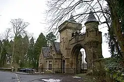
| |||
| Rosebank, 21 Lanark Road, Including Boundary Wall And Railings | 55°43′33″N 3°54′08″W | Category C(S) | 5284 | Upload Photo | |||
| Larkhall, Larkhall Viaduct | 55°43′49″N 3°59′07″W | Category B | 5168 | Upload Photo | |||
| Dalserf Village, 4 Kirk Road | 55°44′04″N 3°54′47″W | Category B | 5169 | Upload Photo | |||
| Larkhall, Duke Street, Larkhall Cemetery, Including Gates Gatepiers, Boundary Walls And Railings | 55°44′42″N 3°58′03″W | Category C(S) | 45114 | Upload Photo | |||
| Larkhall, 51 Hamilton Street | 55°44′42″N 3°58′32″W | Category C(S) | 45116 | Upload Photo | |||
| Rosebank, Lanark Road, The Popinjay Hotel, Including Gate, Gatepiers And Walls | 55°43′35″N 3°54′09″W | Category B | 5167 | Upload Photo | |||
| Broomfield Road, Broomfield Farm, Including Enclosing Walls | 55°42′20″N 3°56′01″W | Category B | 45107 | Upload Photo | |||
| Dalserf, The Orchard, Including Gatepiers, Part Boundary Walls And Railings | 55°43′59″N 3°54′48″W | Category C(S) | 45109 | Upload Photo | |||
| Larkhall, Gallowhill Road, Robert Smillie Memorial Park Gates | 55°44′08″N 3°58′23″W | Category B | 45115 | Upload Photo | |||
| Canderside Bridge, Cander Water | 55°42′17″N 3°57′58″W | Category A | 6452 | Upload Photo | |||
| Dalserf Village, Dalserf Parish Church, Church Of Scotland, Including Walled Churchyard, Gatepiers And Gates | 55°44′06″N 3°54′47″W | Category A | 5170 | 
| |||
| Mauldslie Bridge, River Clyde | 55°43′51″N 3°54′24″W | Category A | 5175 | 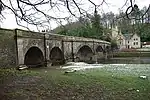
| |||
| Ashgillhead, Ashgillhead Road, Rorison Memorial Church, Including Memorial Obelisk | 55°43′48″N 3°56′04″W | Category C(S) | 45106 | Upload Photo | |||
| Dalserf, Lanark Road, Dalserf House Lodge, Including Boundary Walls, Gatepiers And Railings | 55°43′59″N 3°54′40″W | Category C(S) | 45108 | Upload Photo | |||
| Larkhall, Raploch Road, St Mary's Rc Church | 55°44′09″N 3°58′53″W | Category C(S) | 45119 | Upload Photo | |||
| Larkhall, Raploch Road, St Mary's Primary School, Including Gatepiers And Boundary Walls | 55°44′08″N 3°58′56″W | Category C(S) | 45120 | Upload Photo | |||
| Larkhall, Union Street, Glengowan Primary School, Including Boundary Walls, Gatepiers And Railings | 55°44′20″N 3°58′22″W | Category C(S) | 45122 | Upload Photo | |||
| Dalserf, Off Millburn Road, Auldton Farm, Including Gateway And Outbuildings | 55°43′47″N 3°55′16″W | Category B | 5173 | Upload Photo | |||
| Dalserf, Millburn House, Including Gatepiers | 55°43′54″N 3°55′06″W | Category B | 5174 | Upload Photo | |||
| Rosebank, Lanark Road, Marna, Including Boundary Wall | 55°43′41″N 3°54′19″W | Category C(S) | 5177 | Upload Photo |
Key
The scheme for classifying buildings in Scotland is:
- Category A: "buildings of national or international importance, either architectural or historic; or fine, little-altered examples of some particular period, style or building type."[1]
- Category B: "buildings of regional or more than local importance; or major examples of some particular period, style or building type, which may have been altered."[1]
- Category C: "buildings of local importance; lesser examples of any period, style, or building type, as originally constructed or moderately altered; and simple traditional buildings which group well with other listed buildings."[1]
In March 2016 there were 47,288 listed buildings in Scotland. Of these, 8% were Category A, and 50% were Category B, with the remaining 42% being Category C.[2]
Notes
- Sometimes known as OSGB36, the grid reference (where provided) is based on the British national grid reference system used by the Ordnance Survey.
• "Guide to National Grid". Ordnance Survey. Retrieved 12 December 2007.
• "Get-a-map". Ordnance Survey. Retrieved 17 December 2007. - Historic Environment Scotland assign a unique alphanumeric identifier to each designated site in Scotland, for listed buildings this always begins with "LB", for example "LB12345".
References
- All entries, addresses and coordinates are based on data from Historic Scotland. This data falls under the Open Government Licence
- "What is Listing?". Historic Environment Scotland. Retrieved 29 May 2018.
- Scotland's Historic Environment Audit 2016 (PDF). Historic Environment Scotland and the Built Environment Forum Scotland. pp. 15–16. Retrieved 29 May 2018.
This article is issued from Wikipedia. The text is licensed under Creative Commons - Attribution - Sharealike. Additional terms may apply for the media files.